Hello everyone, Meteorologist Christopher Cawley here with tonight’s weather update, for Tuesday October 29, 2024.
“High and dry.” That’s the running narrative for the rest of the week and the weekend. Ghouls and goblins should have no issues on Halloween night as we’ll have warm temps and dry conditions. We will kick off the month of November with temperatures continuing to run well above normal and no rain in sight.
A dry cold front moves through Saturday but we really won’t notice much other than temps being knocked down a few degrees over the weekend, but the longer-range modeling hints at 80-degree temps returning next week.
My mentor taught me many years ago, “when in drought, forecast drought.” There’s really nothing coming down the pike that would suggest that’ll change through at least November 5-6. Scrolling the latest GFS modeling suggests no rain through at least November 8… but once we get past about 5-7 days that becomes something of a crapshoot. GFS also shows a tropical system in the Gulf by about the 9th of November, but again, that’s just too far out to take with any level of seriousness.
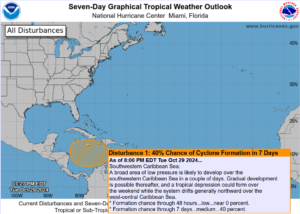
Tropics: The National Hurricane Center is still watching a low pressure area currently organizing in the Caribbean Sea. This low is expected to move slowly to the north and there remains a 40% risk of this developing into a tropical depression over the next 7 days.
The GFS modeling (for what it’s worth) shows tropical development south of Cuba, drifting westward toward the Yucatan, and then lifting northward into the Gulf of Mexico through November 9th. I think that’s too far out in time to really predict but, in all honesty, the modeling has been very persistent in spinning up a tropical low in the Caribbean. We’ll see.
That wraps up our report for tonight. I thank you for reading, and as always, take care.


