Hi again everyone, Meteorologist Christopher Cawley here with your weather update for Wednesday evening, October 16, 2024.
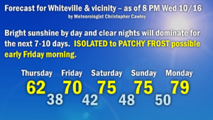
STRONG high pressure will absolutely dominate our weather through the foreseeable future. Short- and long-range modeling suggests no precipitation… nothing… nada… zilch… for the Whiteville area for the next 7-10 days. So really it’s just a temperature forecast as we move through the next week.
The biggest question — will there be frost late Thursday night into early Friday morning? The quick answer is: Probably. Lows will drop to the upper 30s, even in town, but the best frost potential will be north and west of town, and then as you head north into Bladen or northwest into Robeson counties. I think places like the Charter School will see readings in the 35-38 degree range early Friday, while in town we’re probably looking at 37-40. So far there are no advisories issued locally, but it would probably be a good idea to make sure those tender plants are taken care of before you go to bed Thursday night.
Bright sunshine continues through the weekend with temperatures rapidly warming to seasonal norms… and then above normal as we go into next week. Highs Saturday and Sunday should be in the lower to middle 70s with lows in the 40s. Highs should be a few ticks either side of 80 as we start off next week, with lows generally in the 50s. Again, no rainfall in sight.

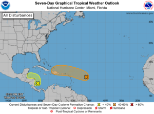
TROPICS: Still watching an area of low pressure in the central tropical Atlantic with showers and thunderstorms. The environment is still quite unfavorable for further development, but as the system drifts westward by this weekend, there is still a 40% probability this develops into a tropical system. I have zero concern of this taking a run up the coast thanks to a huge ridge of high pressure dominating the eastern third of the continental US.

Ok that’ll wrap it up for this update. Thank you for taking the time to read this, and as always, take care.


