Good evening… here’s your weather update for TGIF November 1, 2024.
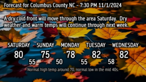
The only thing going in the weather world for us is a cold front, which will move through the area on Saturday. This front will be followed by yet another ridge of high pressure which will take hold keeping dry weather and unseasonably warm temps through next week.
This ridge overhead keeps rain chances to near zero through at least next Thursday. The modeling hints that the ridge starts to weaken by the end of next week, allowing a more moist flow to take shape. There’s a hint that some rain showers could be in the offing by next weekend but that’s too far out in time to make any definitive call.

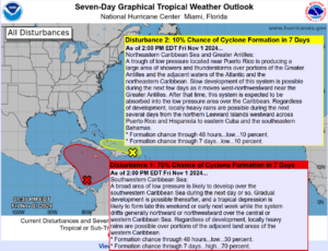
Looking at the tropics, there are still two areas of interest. The first one is one we’ve been watching for the last week, and it finally looks like this will materialize into our next tropical system by Sunday or Monday. EPS (European) tropical spaghetti plots suggest this will move between the Yucatan and Cuba and into the Gulf… and from there it’s anyone’s guess. Too early to make any call on a storm that hasn’t even formed yet.
The other disturbance isn’t really going to amount to much as it gets merged with a non-tropical low and frontal system. NHC gives it a 10% chance of becoming tropical in nature before this happens.
Don’t forget to set those clocks back Saturday night before you go to bed, and enjoy the extra hour of sleep. That’ll do it for tonight’s update, thanks for reading, and take care.


