Good evening! Meteorologist Christopher Cawley here with your weather update for Monday, November 25, 2024.
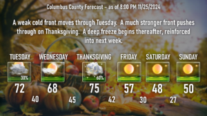
Summary: A cold front crosses the area Tuesday. Dry and mild conditions on Wednesday ahead of a strong storm system that moves through late on Thanksgiving. Brutal Arctic cold arrives on Black Friday, lasting well into next week.
Through Tuesday night: Skies will be clear through the night tonight, and temperatures will only fall to around 50. Above-normal temperatures will continue on Tuesday. Clouds will be on the increase, and we have a chance for showers during the afternoon hours. The front will be fairly starved of moisture so I don’t think the rainfall will be anything to write home about. That all clears on out Tuesday night with cooler temps, lows around 40.
Wednesday: The busiest travel day of the year will feature no local travel concerns. Keep the sunglasses handy and enjoy the nice temps… sunny skies with highs in the upper 60s to around 70. Meanwhile, a strong storm system takes shape and a strong cold front becomes established.
Thanksgiving: The front moves through during the afternoon. We should start off dry, but showers and thunderstorms are a good bet during the afternoon hours. There may be a very low-end severe weather risk late on Thanksgiving day as modest instability takes shape over the county. Thanksgiving will be warm and breezy with highs in the mid 70s.
Thursday night: Shower chances diminish by midnight as the front moves off the coast. Cold air starts to push in from the west/northwest, and our lows drop to the lower 40s.
Black Friday: Sunny skies, somewhat breezy. Our highs might make it to the mid to upper 50s (upper 50s is the “normal” for this time of year). I think I’m being optimistic by putting a “57” on the graphic.
Friday Night through the weekend: Dry weather but COLD temperatures. Dress warm if you’re headed out to Legion to cheer on the Wolfpack as temps will drop into the 30s during the game. Highs Saturday and Sunday will struggle to reach the 50-degree mark while lows drop to the upper 20s Friday night, Saturday night, and Sunday night.
Monday through Wednesday of next week: The deep freeze continues, with a reinforcing shot coming in Sunday night. The peak of the cold snap appears to come on Tuesday, at least according to the modeling, with highs struggling to reach the lower 40s, and lows in the lower to middle 20s… it wouldn’t surprise me to see temps around the 20-degree mark early Tuesday and Wednesday mornings.
Things get a little bit interesting Sunday night into Monday. A dry cold front will push through the area late Sunday. That’s all well and good. The GFS modeling hints at low pressure spinning up along that front. Now there are a lot of “if’s” that come with this. IF the low organizes, how much moisture will there be with it…? IF the low organizes, will it be in a “Goldilocks Zone” off the coast where snow could fall across the area…?
It’s way too soon to tell, and honestly, conditions have to be juuuust right for snow to fall in Columbus County. The GFS isn’t very aggressive with this low, keeping it relatively starved of moisture, and the European doesn’t show anything at all. Perhaps I’m just “wishcasting” here but I’ll keep an eye on developments. As of right now, though, yeah… don’t get excited.
Tropics: No activity is expected through the end of the season. Not even going to post a graphic because there’s nothing doing. Since the season comes to an end this weekend, I will discontinue tropics updates unless something freak develops.
That’ll do it for tonight folks. Thank you for your time, and as always, take care!


