Hello everyone, Meteorologist Christopher Cawley here with today’s weather update, for Monday November 4, 2024.
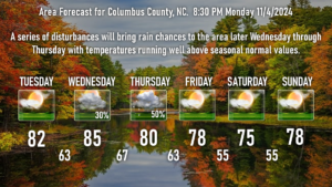
RAIN is in our future, Columbus County! Not a lot of rain, mind you, but modeling suggests anywhere from a quarter to perhaps half an inch of rainfall from late Wednesday afternoon through late Thursday evening, coming in the form of occasional showers. This is due to a series of weak disturbances running up the coast around a huge ridge of high pressure. This is the same high that has been keeping us dry and warm for what seems like ages. Enough subtropical moisture is able to work its way along this trough/disturbance, which will give us some much-needed rainfall. Again, this isn’t a drought-buster or anything like that, but every little bit helps.
After that, high pressure reasserts control through the Veterans Day weekend with dry weather and a continuation of unseasonably warm temps.
Speaking of unseasonably warm temps, record highs are possible Wednesday as we reach the mid 80s before the clouds take over. With clouds and showers in the area Wednesday night, our temps only drop to the upper 60s, which would be considered a “record high low temp.” For reference, normal highs in the mid 80s and normal lows in the upper 60s are something we should experience in early September or early May … NOT early November (actual normal values are upper 60s for highs, mid 40s for lows).

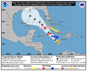
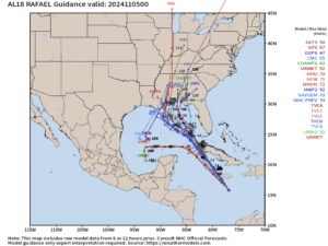
Tropical Storm Rafael is just south of Jamaica as of this writing. He will lift northwestward, becoming a hurricane by Tuesday afternoon. The current forecast track calls for Rafael to lift northwest and impacting the western part of Cuba, before pushing into the Gulf of Mexico. From there, we have a bit of a wide variance in modeling. The big ridge of high pressure will still be largely in place over the western Atlantic ocean, with a decaying cold front somewhere in the region. Right now the latest modeling suggests a northward turn and the storm possibly coming ashore anywhere from central Louisiana to the Florida panhandle.
I find it modestly interesting that the NHC official forecast has the storm a bit farther west than the “cluster” of model plots. Hmm.
Wherever he goes, it is likely that Rafael will weaken significantly as he pushes northward through the Gulf thanks to dry air in place and considerable wind shear — both of which are very hostile to the life of a tropical system. No concerns right now for impacts in the Carolinas.
Ok folks, that’ll do it for tonight’s update. Thank you for reading and take care!


