Good evening everyone, Meteorologist Christopher Cawley here with your weather update for Saturday evening, November 16, 2024.
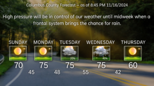
High pressure will remain firmly in control of our weather through at least the first half of Tuesday. A cold front is expected to move through by midweek, which will bring our next chance for showers. Temperatures will be warm for the first half of the week… but behind the cold front we tumble to slightly below normal readings for Thursday and into next weekend. Frost potential remains zero until possibly early next Friday when modeling shows the potential for temps in the upper 30s.
Beyond the immediate forecast period, the GEFS ensemble temperature outlook calls for a return to generally above-normal temps through Thanksgiving and the end of the month with little chance for frost or freeze.
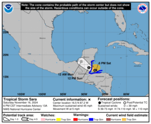
Tropics: Tropical Storm Sara continues to move north of the Honduras coastline, clinging to life at this time. Sara is expected to move over Belize and the Yucatan Peninsula of Mexico through Monday. After moving inland, weakening should begin and the global and hurricane-regional modeling continues to indicate Sara will devolve into a trough as it emerges into the Gulf of Mexico. The remnant moisture will continue to move northward and likely act as a focal point for enhanced rainfall ahead of the next frontal boundary along the northern Gulf coast by the middle of next week.
That will conclude this weekend’s weather update. Enjoy the nice weather over the net few days, and as always, take care.


