Good evening, Meteorologist Christopher Cawley here with the weather update for Tuesday November 26, 2024.
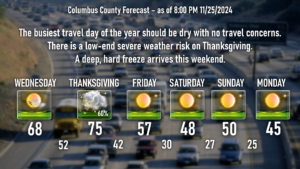
The busiest travel day of the year should provide no problems in terms of weather. Keep sunglasses handy, you’ll need them as sun-splashed skies will be over the area, with mild temps in the upper 60s to around 70.
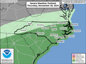
The main focus of tonight’s update will be the front moving across the area on Thanksgiving Day. This will bring the threat for showers and thunderstorms. There is a low-end severe risk, and the Storm Prediction Center has placed Columbus County under a “marginal risk” (level 1 out of 5) for Thanksgiving afternoon and evening. The primary threat will be from ISOLATED damaging wind gusts. I don’t think the conditions are going to be in place for a squall line to develop, and the instability numbers I’m seeing in the modeling just don’t look all that impressive, so I don’t expect anything more than, again, a few ISOLATED damaging wind gusts.
Take the word “thunderstorm” with a grain of salt as well. This will likely be a case of “gusty showers,” devoid of lightning/thunder given the limited instability.
Then… it gets cold. And I mean cold. As I’ve been writing for the last few updates, a deep Arctic freeze is coming to the area for the weekend and especially through the early to middle part of next week.
Temperatures on Friday will actually be where they should be this time of year — middle to upper 50s. Temps quickly fall back Friday evening, and by halftime of the Wolfpack game, I expect us to be knocking on the door of the 30s. Expect temps by sunrise on Saturday to be around 30, with upper 20s north and west of Whiteville.
Our highs on Saturday and Sunday will struggle to reach the 50-degree mark, even with a nearly cloudless sky. Perfect radiational cooling conditions take place Saturday night and Sunday night allowing our temps to plunge deep into the 20s… it will be in the mid 20s at the bus stop on Monday morning when those kiddos go back to school.
I mentioned yesterday that a dry cold front will move through late Sunday, reinforcing the cold air in place. Modeling (mainly the GFS) hinted that a low might try to spin up on that front, but at this time it doesn’t look like that’s going to be the case. So while it will be cold enough for snow, it doesn’t look favorable for any kind of snowfall across the county.
Modeling suggests that temperatures gradually … and I mean gradually … start to warm toward seasonable normal values toward the end of next week (the first week in December). GFS ensembles push our highs back up close to 60 by Friday/Saturday December 6/7.
If you want to see some deep snows, the lake effect machine will be running in full force across portions of upstate New York. An area called the Tug Hill Plateau, just south of Watertown, NY, could receive 3 to 5 FEET of snow through the first week in December. Yeesh.
Ok friends, that will wrap it up for tonight’s update. Thank you for reading, and as always, take care!


