As the song says, “let it snow, let it snow, let it snow!”
Unfortunately… this time around anyway… it’s not likely to amount to more than just a few flurries.
Meteorologist Christopher Cawley here with your weather update for Monday evening, December 2, 2024.
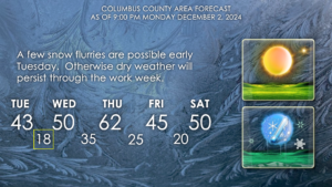
The deep freeze continues through Tuesday night. And a few snow flakes are possible early Tuesday!
Let’s talk about the snow chances. I’m not really on board the “snow train,” but I’ve seen much mention of it on social media. A small weather disturbance called a “shortwave” will dive southward over North Carolina tonight. Modeling suggests this will bring some areas of snow to the state.
The best chances for accumulating snowfall … that is to say maybe up to half an inch in the grassy areas … is west of I-95. If you’re traveling along 74 toward Rockingham or Charlotte, then your chances of experiencing snowfall are much greater than here in Columbus County.
That being said, as our kiddos are at the bus stop in the morning, or you’re on your way to work, there may be a few snow flakes flying through the air.
Oh, yeah, it’s going to be COLD tomorrow morning at the bus stop, and even COLDER on Wednesday morning.
For Tuesday morning, expect temps 21-25.
For Wednesday morning, expect temps 16-20.
No joke. PLEASE make sure your kids are dressed appropriately for this.
Just a reminder as well that a warming station has been established in Whiteville at the Facts of Life Church. They will be open from 7 PM to 7 AM tonight (Monday night) and Tuesday night. They are located at 506 Lee Street in Whiteville.
We will experience a bit of a warmup by Thursday, but don’t get used to it as another Arctic front pushes through. Friday will be very cold once again, and if you’re going to Round 4 at Legion Stadium, be sure to bundle up. The next cold snap should only last Friday and Saturday as temperatures look to rebound Sunday into early next week.
That’ll do it for this update, thanks for reading, stay warm, and take care!


