Welcome readers to your daily weather blog from Meteorologist Christopher Cawley.
We have a very foggy morning across the county. Please give yourself some extra travel time. We’re getting this thick fog thanks to abundant moisture at the ground level below a temperature inversion a few hundred feet off the ground (temperature actually warming with height instead of cooling).
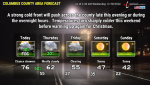
The fog and low stratus clouds will take their sweet time “mixing out” this morning. Once that takes place, temperatures jump thanks to a southerly flow. I expect a mix of sunshine and clouds on the whole for today. A significant cold front starts to approach from the west late this afternoon. I believe there will be enough moisture pumping up from the south that we get a few scattered showers later this afternoon. Nothing widespread or dramatic, and on the graphic I put the rain chances at 30 percent.
Better chances for showers and even some thunder tonight as the cold front whisks its way over the county. This should occur sometime around or shortly after midnight. Overall rainfall totals should remain fairly light. I put in a 50-percent note on the graphic to indicate the increased chance for rain tonight… but this will be a situation where not everyone gets rained on. The showers should be scattered at most, and the thunder threat is low. Definitely nothing severe. It’ll be a bit breezy, especially along and just ahead of the front, but I don’t think it’s going to be anything about which to get too excited.
Once the front clears the coast, a shallow layer of colder air will push into the county on Thursday, as another weak disturbance kind of pinwheels over NC during the afternoon. This will keep lots of clouds across the county, spotty light rain showers (about 30% probability). I am optimistic in putting “62” on the graphic but if we get any showers, that will be a bit too warm — we’ll likely remain stuck in the upper 50s…
…which will feel downright hot compared to what’s coming this weekend. A big bold Canadian air mass plunges southeastward and impacts much of the eastern US this weekend. This will result in highs being stuck in the 40s. I’m being generous by putting a 42 on the graphic for Sunday… expect temps to stay in the upper 30s much of the day. The deep freeze culminates Sunday night (not shown on the graphic) with temps in the upper teens. Nope, it’s not going to snow.
CHRISTMAS OUTLOOK: The GFS and Euro models are on completely different planets… but they do agree that Christmas Eve and Christmas Day should be dry. The GFS says our highs jump into the 70s on Christmas Day, while the Euro says, “calm down mate,” keeping it seasonable with highs in the upper 50s. I think the GFS is hitting the eggnog a bit hard so, for now, plan on temps a few ticks either side of 60.
That concludes today’s blog post. Thank you for reading, thank you for supporting ColumbusCountyNews.com, and have a wonderful day.


