Hi everyone, Meteorologist Christopher Cawley here with the CCN Weather Update for Thursday January 2, 2025.
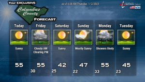
Quiet weather conditions will persist through early Sunday thanks to high pressure in place. This high will dip south/east and allow a cold front to cross the state on Friday. This will bring some cloudiness and maybe, perhaps, possibly an isolated rain shower early in the day on Friday. The weekend will be sunny and cold with highs stuck in the 40s and lows deep into the 20s.
Things start to get more active as we get into next week with a frontal system that will approach Sunday night and cross the area on Monday. I believe this will be an all-liquid event (much more detail down below).
LONG TERM—
For the longer term, and the severe cold outbreak potential for late next week and beyond, the modeling is being agonizingly inconsistent from the upper levels all the way down to the surface conditions.
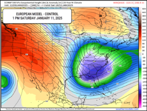
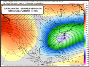
“Control” versus ensembles. The model ensembles, when used together, help to “smooth out” what appear to be extremes. The European model control for 1 PM Saturday the 11th shows a deep, frigid air mass over the southeast US. But that’s just one snapshot of one model at one moment in time. I like to look at ensemble averages… and for the same time point the ensemble mean is smoothed out considerably and doesn’t show the air mass as deeply frigid as the control model.
Now, the GFS control/ensembles appear to be on a completely different dimension with regard to the center of the air mass. GFS keeps the coldest center farther to our north, over the mid-Atlantic … and a few days earlier than the Euro (Wednesday night January 9-Thursday January 10). The GEFS (which represents the ensembles), smooths this out, putting the center of the polar mass over NJ/Del/MD.
What does all of this mean? It lowers my overall confidence on the depth of the cold weather outbreak. It’s starting to put doubt in my mind that it will be “all that cold” here. Yes, temps will certainly run a good bit below normal, but I’m starting to doubt those images I saw earlier in the week of readings some 20-30 degrees below normal.
That being said, the Euro CONTROL plot still has a high on Saturday the 11th of 33 degrees. The ensemble mean is 41 for the high… but the spread is huge… the 5-95% percentiles range from a high of 23 at the low end to a high of 62 on the top end. The low temperature spread is equally as wide, ranging from 10 above to about 43.
In short, we’re going to have a cold snap. I just question HOW cold that snap is going to be.
Now… will it snow?
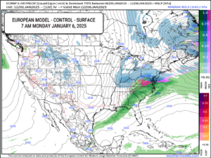
There are a couple of systems to look at here. The first one I am watching will arrive Sunday night through Monday. Cold air will be in place for the weekend. The main low is expected to track from the upper Tennessee Valley across West Virginia, northern Virginia, and then off the coast. This will lift a warm front across our area Sunday night. Some showers are possible during the overnight hours Sunday into Monday. While temps will likely be in the 30s, all sounding profiles suggest an above-freezing temperature for all levels of the atmosphere, so that means cold rain. Temperatures will be rising as we go into Monday morning, and showers are likely as this system moves through. The European (map below) control shows a decently aggressive little system with a secondary low forming off the NC coast. Either way, this will be a rain system from start to finish.
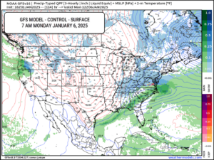
The GFS model is in decent overall agreement with Euro on this system. Showers move into the area Sunday night, and with all layers above 32°F, it’ll be rain. Showers on Monday as the front moves through… coming to an end late Monday night. GFS hints that enough cold air funnels in that we get a very brief period of light snow on the tail end of the system, but I really doubt it.
JANUARY 9-11: The next one I’m looking at (as is everyone else, really), forms on the southern jet stream roughly late in the day on the 8th and starts to really take shape on the 9th in the northern Gulf. The Euro brings this just off the GA/SC coast by the morning of the 11th… but at this time depicts an all-rain event, primarily off the coast, with little or anything here locally. Now, this is 240 hours out so take this all with a huge grain of salt. The model is wishy-washy… previous runs for the same time either a) don’t show this system at all, or b) show this being a significant winter-weather event for the Carolinas.
The GFS forms a southern stream low on the 9th over the northern Gulf. The control has colder air all the way to the coast with snow falling in southern Alabama, Georgia, and the Florida panhandle. I’m not so sure I buy that, even with double-coupons. Anyway, the low crosses Florida, turns the coast…… and moves clean on out to sea. All we would get here are some rain showers, maybe mixed with some snowflakes from time to time.
This, too, is wishy-washy, as previous runs also shuffle from a blockbuster storm to a nothing burger.
I’m not going to post those graphics at this time, because they’ll change 12,347 times in the next 5 days. Just know that the period between the 9th and the 11th seems to be the time to be watching.
The NWS Climate Prediction Center put out a chart earlier on Wednesday showing all of the Carolinas under a “slight risk for heavy snow” for January 9-10. This represents a 20% to 40% risk level.
We must be careful. It’s easy to “wish cast.” I want to see snow here just as bad as anybody, especially if it is going to be unseasonably cold. But a very precise set of events has to come together absolutely perfectly for that to happen. I don’t want to “invent” things in the tea leaves that don’t exist.
More often than not, snow occurs in Columbus County as cold air “chases” a departing storm system. That probably won’t be the case this time as cold air should be locked in place already (for the 9th through the 11th). In this case, it’s all about location, location, location with the low pressure on the southern stream… if one even develops. Way, way too soon to make any specific calls.
Ok friends, that’ll do it for this lengthy report. Thanks for reading all the way through and thank you for supporting Columbus County News! As always, take care.

