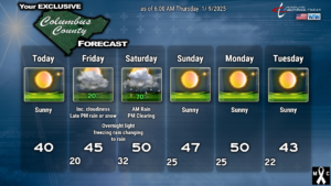
Hello readers, welcome to the CCN Weather Update for Thursday January 9, 2025.
All eyes are focused on the weather event slated to arrive late Friday afternoon and last through late-morning Saturday.
Arctic high pressure drifts offshore tonight. This allows a low pressure system to lift northward from the Gulf Coast through southern Georgia, and then along the South and North Carolina coast through Saturday.
An area of moisture is shown to RAPIDLY move over the area later Friday afternoon. There will be dry air in place at the surface which will be difficult to push out. Therefore, precipitation from the cloud level will evaporate as it falls through the air. This cools the air (called evaporative cooling) and supports a short period of frozen precipitation. There may be snow flurries/light snow toward suppertime on Friday, particularly for western sections of the county, but on the whole I believe that we will see light rain develop during the evening hours. As the storm center lifts northward, warmer air will push in, first at mid-levels of the atmosphere (called a “warm nose”), while temperatures at the surface might lag a degree or two below freezing. This sets the scene for freezing rain, and I believe we will have light (key word — light) freezing rain showers primarily from roughly 10 PM to perhaps 2 AM Friday night into Saturday. Eventually the warm air will fill out the entire atmospheric column, cloud to ground, and we go to all rain. Periods of rain continue through about mid-morning Saturday. We’ll see clearing skies Saturday afternoon as the low pressure center quickly pulls away. Colder air will wrap back in behind the storm, but by then, the precipitation is long gone.
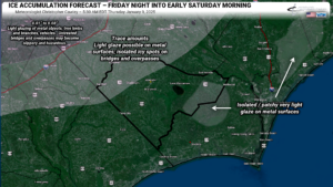
As far as ice accumulations go, I believe that the western portions of the county, as well as nearly all of Robeson county and the majority of Bladen county, may see trace amounts of freezing rain. There may be a light glaze possible on metal items and vehicles. ISOLATED icy spots on secondary roads, bridges/overpasses may occur, but I think that’ll be a worst-case scenario. Eastern portions of ColCo may see some very isolated/patchy areas of very light glaze, but honestly I don’t think that’ll be very long-lived as temps go above freezing during the overnight hours.
Snow accumulations — well, if you want to see snow, you’ll need to take a little road trip toward Laurinburg and Rockingham, or get north and west of Fayetteville.
It’s “probable” that the National Weather Service will issue a Winter Weather Advisory for at least Robeson and Bladen counties… maybe Columbus. Their criteria is ANY accretion of ice from freezing rain, so I wouldn’t rule it out.
Even now, there are STILL some differences in modeling, but I’m hedging my bets on the Euro solution of a coastal low. If the storm tracks inland, no frozen precip will occur; we’ll have periods of rain Friday night, ending early on Saturday. If the storm, for whatever reason, tracks 50-100 miles offshore (and this is really unlikely), then we could see snowy or icy conditions here. Only 3 of 30 GFS ensemble members have snow here… but on the other hand, 25 of the 50 Euro ensemble members point to at least half an inch of snowfall, so there’s that. I just don’t see it happening.
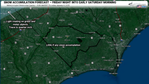
After the storm pulls out of here, a prolonged dry period is likely as high pressure builds back into the eastern US. A few clipper systems go off to our north, and one drags a dry cold front late Monday night, but nothing of significance is looming in our immediate future.
One of the tools in the forecaster’s toolbox is teleconnections. Today I’m going to show you the North Atlantic Oscillation (NAO).
The NAO is a weather phenomenon that measures the difference in atmospheric pressure between the Azores High and Icelandic Low. The Azores are a series of islands located over the east-central Atlantic Ocean, west of Portugal and mainland Europe. Iceland is located far to the north, off the east coast of Greenland.
The NAO has three phases – positive, negative, or neutral. 99% of the time the NAO is either in the positive or in the negative.
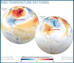
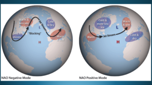
When the pressure is higher than average over the Azores Islands and lower than average over Iceland, the NAO is in a “positive phase.” This is associated with, among other things, mild and relatively quiet winter conditions across the eastern United States.
If, however, the pressure is lower than average over the Azores Islands and higher than average over Islands, the NAO is in a “negative phase.” This is associated with colder-than-normal temperatures as well as stronger cold-air outbreaks and increased storminess in the eastern United States. We’ve been in an NAO-negative phase since January 2nd.
Now, let’s examine the latest modeling, as shown here.
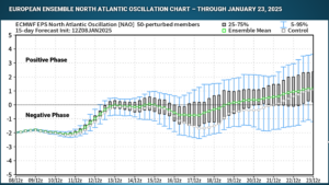
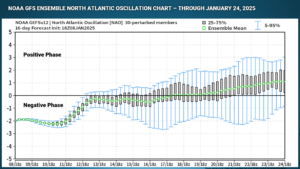
Both the European and GFS ensembles show a strongly negative NAO at the current time, generally persisting through roughly the 19th when the ensemble mean value (shown by the green square in the center) rises above the neutral mark.
The lower ends of the brackets, representing the 5-95% values, continue to run deep in the negative territory through the 23rd.
As the NAO rises above neutral, we should see our temperatures start to climb back toward seasonal normal values.
The NAO is just one of multiple global teleconnections that have impacts on temperatures and weather conditions over the eastern United States, all the way down to Columbus County, NC. As we get into the more prolonged dry period, I’ll pull back the curtain a little more and we’ll examine more of these teleconnections.
Ok folks, that’ll wrap up today’s report. Have a great day, and as always, take care.
–Meteorologist Christopher Cawley

