


Welcome to the Saturday edition of the CCN Weather Update.
Sponsoring your CCN Weather Update is Freedom Insurance in Whiteville. Freedom believes that life is full of surprises, but that doesn’t mean you have to face them unprepared. Whether it’s your home, car, health, or future, Freedom Insurance is here to give you the peace of mind that comes with knowing you’re covered. With affordable plans, personalized service, and a team that truly cares about your well-being, Freedom Insurance has your back when it matters most. Contact Freedom at 910-640-2828 or stop in today!
STATISTICS FOR WHITEVILLE – Friday February 21, 2025.
High: 44.3°F at 3:52 PM (normal is 59)
Low: 19.7°F at 7:07 AM (normal is 35)
Precip: 0.00 in
View live, real-time weather data for Whiteville on my College Street Weather Station.
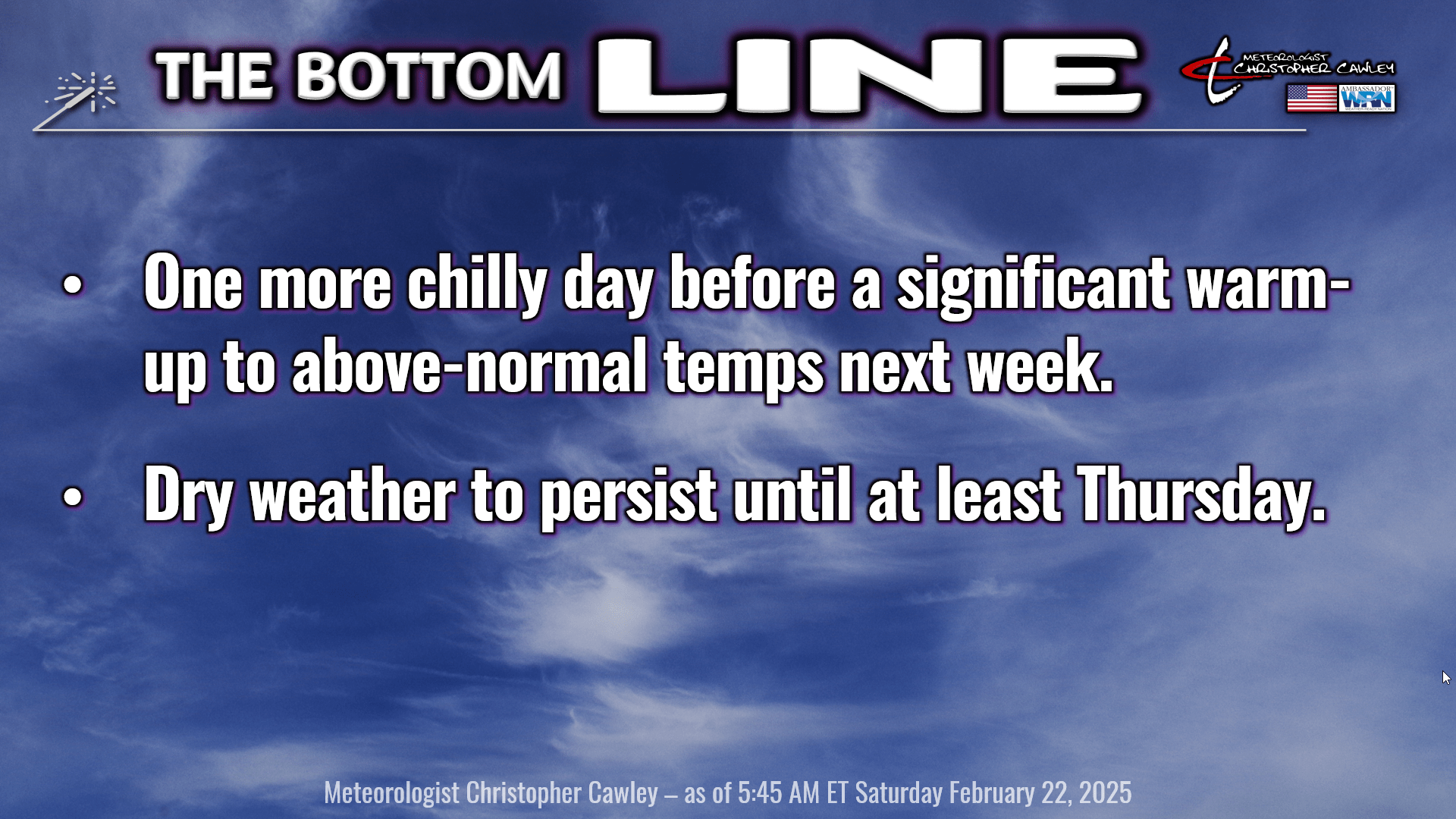
Here’s your Bottom Line for today…
A “shortwave trough” (fancy sciency words for middle level atmospheric disturbance) will move across the state today. There’s not an awful lot of moisture for this thing to work with… but it will bring a period of overcast skies to our area this afternoon into this evening… maybe an isolated sprinkle or two (but I highly doubt it). There’s a better chance for a light renegade rain shower along the coast.
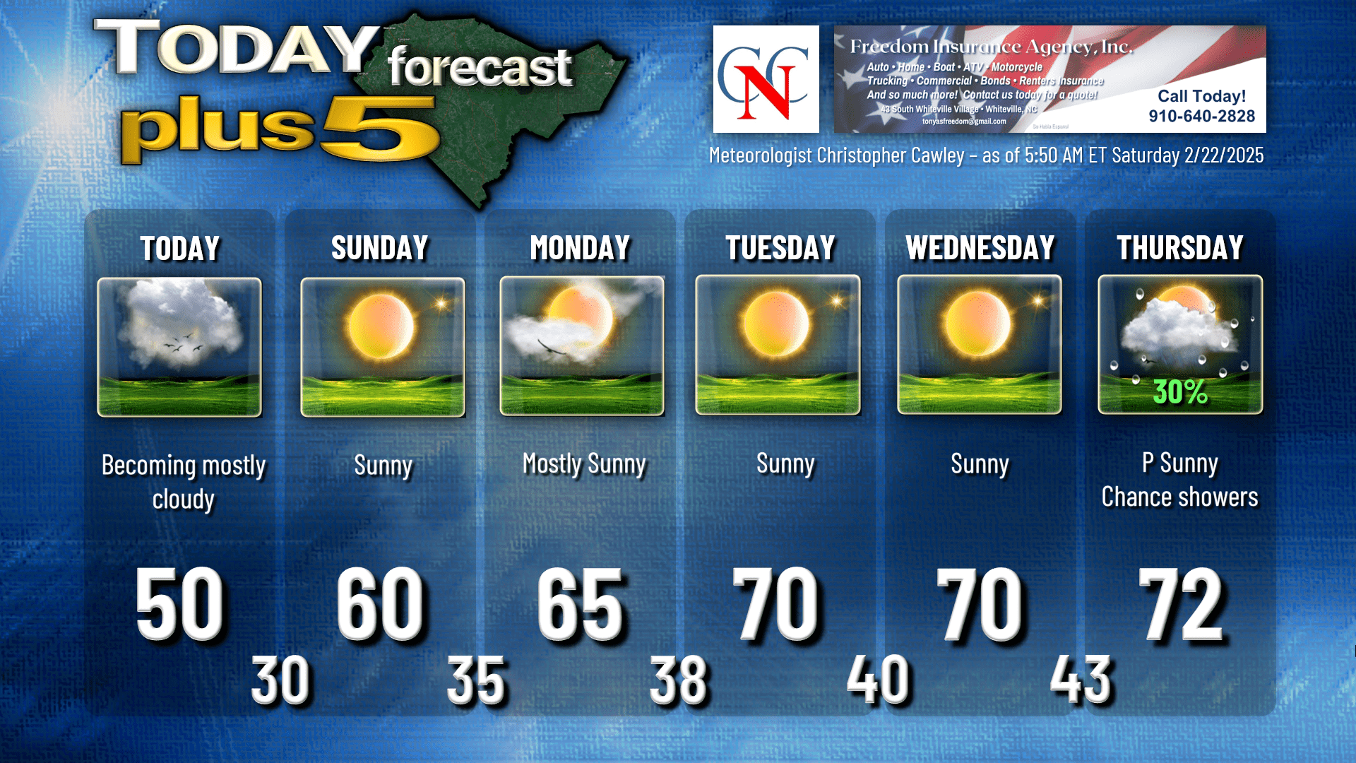
Thanks to the clouds this afternoon our highs are going to struggle to reach the 50-degree mark.
Surface high pressure then retakes control by tonight. The high does it’s best MLB umpire impression, telling the clouds “yerrr outta here!” (Sorry, simply saying “clearing skies” is too boring, so we have to spice things up.) We’ll be cold once again tonight, but in the upper 20s to around 30, as opposed to the upper teens to around 20. No more of that cruelty … hopefully for the rest of the season.
Sunday features temperatures returning to where they should be for this time of year as our winds start to become southerly. Well, more “air flow” than wind, to be honest. Sunday night’s low temperatures also look like they’ll be seasonable.
That’s it for “seasonable” temps as warmer air pushes in from the Gulf next week. I think we’ll see some cloudiness on Monday as a dry frontal boundary drops southeast across the area. The front, bless it’s heart, means absolutely nothing, and in fact our temps Tuesday-Thursday are going to be warmer.
Tuesday and Wednesday are going to be sparkling, spring-like days with tons of sun and highs around 70.
The next frontal system moves through on Thursday. Guidance agrees that this isn’t going to be a very strong system at all, and so I’m going with 30% chances for a shower or thunderstorm on Thursday. Beyond that a return to “seasonable” temperatures. Looking ahead to the first week in March, guidance points to generally seasonable temps (perhaps trending slightly lower) with low-end rain chances.
Here’s your Freedom Insurance Today-Plus-5 forecast for Columbus County.
That’ll do it for today. Thanks for reading, and as always, take care!
~Meteorologist Christopher Cawley

