Greetings friends and neighbors, welcome to the Saturday edition of the CCN Daily Weather Update!
Today’s weather update is brought to you by Freedom Insurance! The professionals at Freedom Insurance have your back covered in the event of any situation. Give them a call and they’ll work with you to develop the best policy for your needs. Contact them at 910-640-2828 or stop by and visit today!
STATISTICS FOR WHITEVILLE – Friday February 7, 2025.
High: 79.4°F at 2:49 PM (normal is 56)
Low: 59.2°F at 6:31 AM (normal is 33)
Precip: 0.42 in
View live, real-time weather data for Whiteville on my College Street Weather Station.
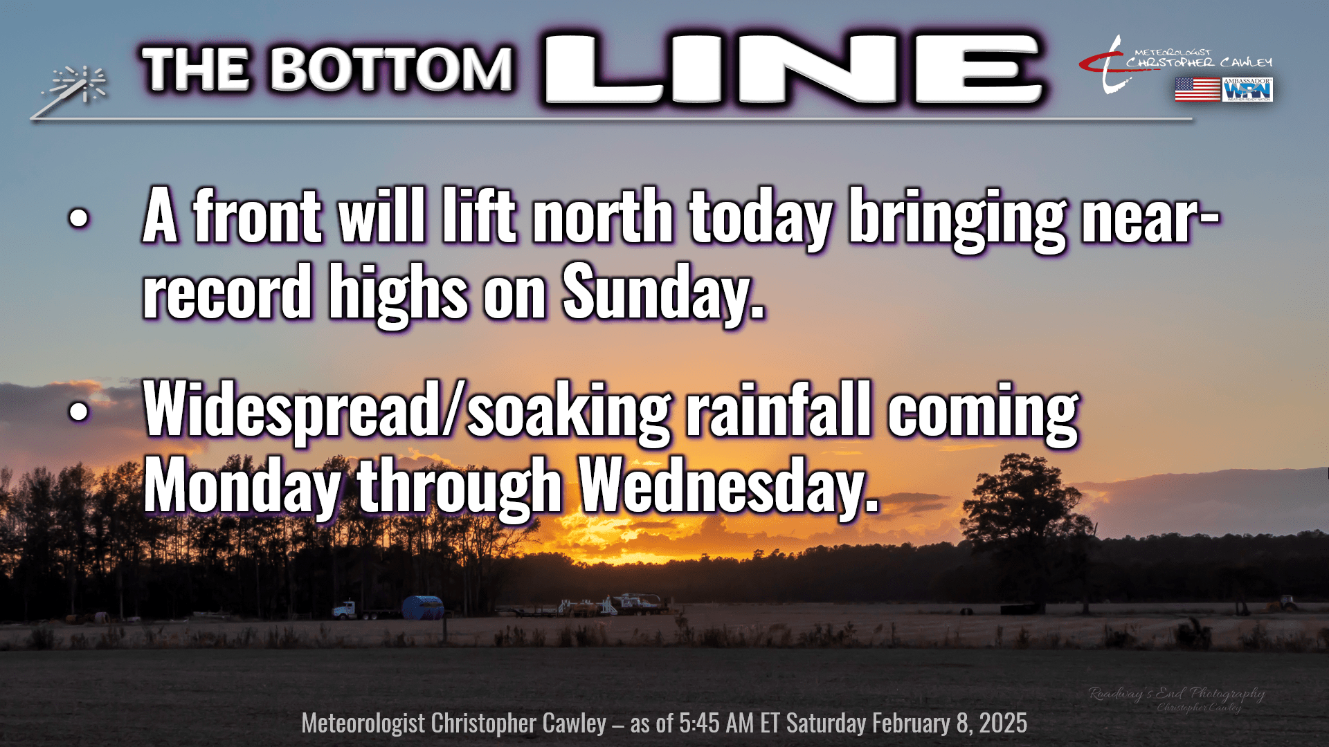
Here’s your Bottom Line for today…
Some of you might have noticed the little thunderstorm that rolled through the northern half of the county just before midnight. That was in association with a frontal boundary dropping south over the area, right on schedule.
As we wake up this morning there’s a “cold-transitioning-to-warm” front extending from northern Oklahoma eastward through Tennessee, and then running just south of the NC/SC state line, and then curving up the NC coast. This frontal boundary will lift north as a warm front as several areas of low pressure take aim on the Great Lakes and northeastern United States.
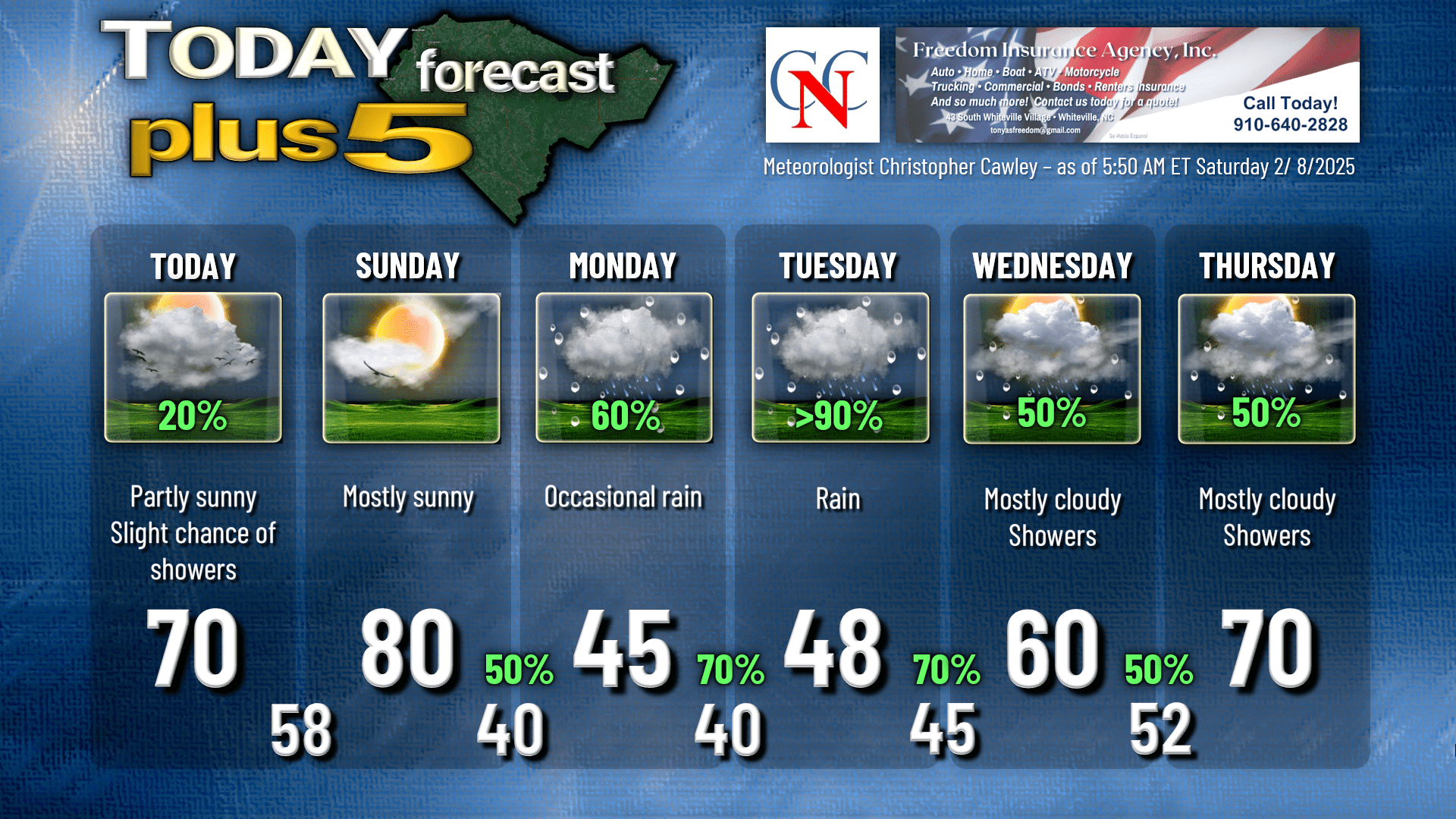
We have a slight chance for some showers this morning as this front lifts slowly northward. I think we’ll see a mix of sunshine and clouds on the whole for today. I put 70 on the chart for a high, but that high may come later this afternoon once that front moves north. If you’re traveling into the northern part of the state, north of a line from say Raleigh to New Bern, temperatures will be stuck in the 40s with periods of light rain. If you’re traveling southbound to Charleston or Columbia, temperatures may reach 80 degrees.
That front lifts well to the north tonight. Our lows reach the upper 50s during the evening, but I believe that by time we wake up on Sunday, temps will be in the lower 60s. We’re well on our way to 80 degrees under a mostly sunny sky on Sunday. Some of the high-resolution guidance suggests the possibility for a few spotty showers on Sunday, and while I kind of agree with that, I didn’t put anything on the graphic.
Then chaaaaange is in the air. A strong cold front moves through Sunday evening. I have upped our rain chances to 50% for Sunday night with this frontal passage. I don’t think we’ll see a LOT of rain, but I believe there will be some showers with the front.
The cold front stalls along the coast on Monday. Waves of low pressure will lift northward along the front bringing periods of soaking rainfall from Monday afternoon through late Tuesday… soaking COLD rainfall. Temperatures will be stuck generally in the 40s through the period.
Guidance suggests the front pushes back to the west by Wednesday, and then lifts north as a warm front Wednesday night and Thursday. Periods of rain continue to be likely Wednesday and Thursday, but since we’ll be in a warmer sector, I expect the rain to be more “showery” in nature. A few breaks of sunshine on Wednesday, more breaks of sunshine for Thursday, and then by Friday I think we’ll dry out with warm temperatures.
LONG(ER) TERM — Modeling suggests our drying-out phase on Friday is short-lived as yet another significant weather system takes aim on the east coast by NEXT weekend with rain and thunderstorm chances. An overall active weather pattern is likely to persist for most of the 2nd half of February. It appears that temps will be near normal to perhaps slightly below seasonal normal values. NO frozen precipitation is anticipated… only 1 out of the 82 model ensemble members has snow listed, and only 0.1″ at that.
“Chilly and occasionally rainy” can be used to describe the 2nd half of the month.
Here’s your Freedom Insurance Today-Plus-5 forecast for Columbus County.
Well that will conclude another CCN Daily Weather Update! Thank you for reading (and sharing!) and I hope you have an amazing Saturday. Take care!
~Meteorologist Christopher Cawley