Warm greetings, friends and followers. It’s time for the CCN Daily Weather Update for Tuesday February 25, 2025.
This weather update is brought to you by our friends at Freedom Insurance in Whiteville. For car, home, or future, Freedom Insurance has your back. Stop in or give them a call at 910-640-2828 and their professionals will put together the best policy for you!
STATISTICS FOR WHITEVILLE – Monday February 24, 2025.
High: 68.3°F at 3:50 PM (normal is 60)
Low: 36.1°F at 7:15 AM (normal is 35)
Precip: 0.00 in
View live, real-time weather data for Whiteville on my College Street Weather Station.
Here’s your Bottom Line for today…
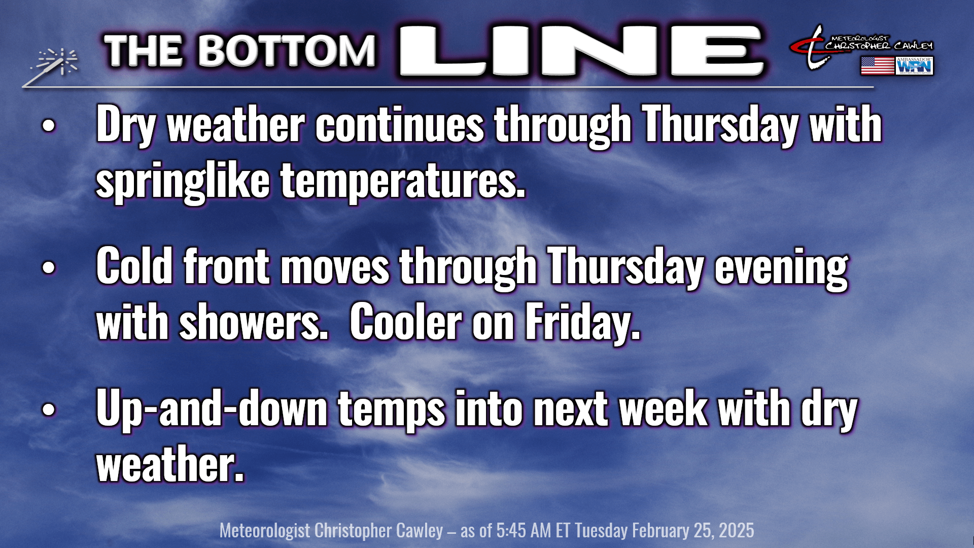
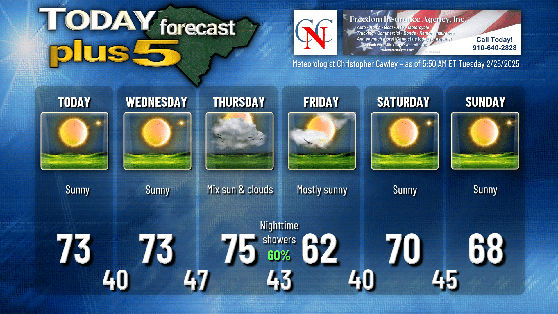
Springlike weather will dominate today, tomorrow, and Thursday. Some areas of fog early this morning will quickly burn off within a few hours of sunrise. Otherwise, expect bright blue sunny skies for today with highs this afternoon in the lower to middle 70s.
Crystal clear skies dominate tonight and with that, our lows will drop to around 40. Some spots may dip into the upper 30s as the kids wait for the bus tomorrow morning.
Nothing but sunshine on the way for Wednesday, with temps again in the lower to (more likely) middle 70s.
For several days now I’ve been telling you about the next weather system, a cold front, which should push through the county Thursday night. Rain chances will increase ahead of the front, in the form of a broken, segmented line of showers (and maybe some rumbles of thunder). Gusty south to southwesterly winds on Thursday push our temps deep into the 70s… possibly upper 70s during the afternoon. I still think we’ll get through the majority of the day without any rain, but clouds will be on the increase.
That segmented line of showers rolls through during the evening hours and ends shortly after midnight. Cold air rushes in behind the front, dropping our lows to the lower 40s.
Friday will be a little bit cooler (actually closer to seasonal normal values) with lots of sunshine. That cooler trend doesn’t last long, as another southerly flow of air sets up for Saturday. A couple of dry frontal boundaries push through on Sunday returning our temps to seasonal normal values for early next week. Dry weather through this whole time period.
Longer-range modeling suggests our next weather system (another cold front) pushes in toward the middle of NEXT week. Both Euro and GFS depict a fairly robust cold front and upper trough, which could bring a thunderstorm threat later NEXT week. No sub-freezing temps expected, although the NBM says Monday the 3rd could start off with temps in the lower 30s.
Here’s your Freedom Insurance Today-Plus-5 forecast for Columbus County.
That’ll do it for today. Thanks for reading, and as always, take care!
~Meteorologist Christopher Cawley