Hello everyone and welcome to your CCN Daily Weather Update for Wednesday March 26, 2025.
This weather update is sponsored by Freedom Insurance of Whiteville. Protect what matters with Freedom Insurance. Life is full of surprises, but with Freedom Insurance, you’ll always be prepared. Whether it’s your home, car, business, or health, we provide customized coverage to keep you and your loved ones secure. Contact Freedom today at 910-640-2828!
STATISTICS FOR WHITEVILLE – Tuesday March 25, 2025.
High: 78.5°F at 4:16 PM (normal is 68)
Low: 53.5°F at 7:43 AM (normal is 43)
Precip: 0.00 in
Average Humidity: 36%
View live, real-time weather data for Whiteville on my College Street Weather Station
Here’s today’s Bottom Line

I’m not quite sure how more clear this point could get made: Extreme. Fire. Danger. Continues. Do. Not. Burn. Officials are now going to be levying fines to those caught outdoor burning.
This fire danger is going to continue today… Thursday… Friday… and into Saturday.
Our next rain chances won’t arrive until Sunday.
And what we get Sunday won’t be much.
Please. Even something as simple as flicking a lit cigarette butt out the window of the car landing just right in the grass, magnified by sunlight, can trigger a flame, which can, within moments, become an out-of-control blaze.
Ok. Now to the weather.
A dry cold front has moved through the area over the past few hours. We’re really not going to notice much, other than slightly cooler temperatures today, tonight, and Thursday thanks to a northwest wind flow. We’re going to see some breezes this afternoon and evening, and with relative humidity levels dropping down to around 25%, the NWS has issued another fire danger statement for the area.
We’ll drop to around 40 or in the lower 40s early Thursday morning. Some isolated spots in the county may fall to the 38-39 degree range but at this point I don’t think we’re going to see any frost….
….and at this point I’m prepared to say with near-100% confidence that we are done with the potential for sub-freezing temps this season.
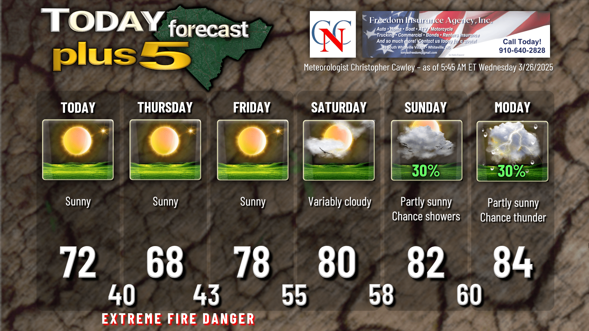
Thursday will feature abundant sunshine with highs in the upper 60s, maybe reaching 70. Add 10 degrees onto that for Friday as high pressure pushes offshore.
Saturday will be the final dry day across the area. A weak frontal system will push through the area on Sunday and this may trigger a few scattered showers, nothing of significance, but every drop counts. We will become breezy, warm, and rather humid on Sunday thanks to a southerly flow from the Gulf. A second frontal system, this one with several areas of low pressure attached, will move through the area sometime Monday, Monday night, or Tuesday. There is a lot of uncertainty in the modeling as to timing of the system and the potential for showers and thunderstorms. Given this disagreement, I’m not going to over-think the scenario. As it stands right now, Monday would be partly to mostly sunny with a chance for thunderstorms at any point in time during the day. Same goes for Tuesday. Plenty of time to pin this down and I can probably give better details by Friday-Saturday as to what we’re going to get. Don’t get your hopes up for a lot of rainfall — the national blend of models has only about a third of an inch of rainfall for Columbus County between the time you read this and the middle of next week.
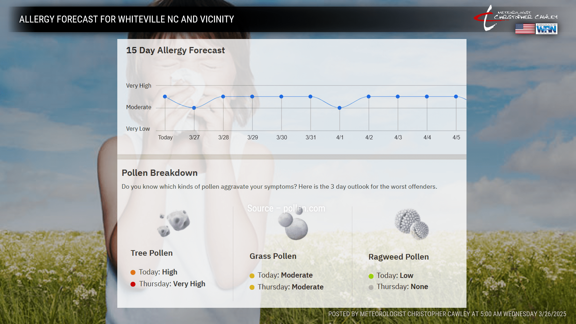
Oh, and the Great Pollen Storm of 2025 continues…
Here’s your Freedom Insurance Today-plus-Five forecast:
That will conclude today’s report. Thanks for reading, and as always, take care.
~Meteorologist Christopher Cawley