Greetings friends, and good day to you! Here is your CCN Weather update for Friday April 25, 2025.
This weather update is sponsored by Freedom Insurance of Whiteville. Protect what matters most with Freedom Insurance. Life can be full of surprises, but with Freedom Insurance, you will always be prepared. Whether it’s your home, car, business, or health, we provide customized coverage to keep you and your family safe. Contact Freedom today at 910-640-2828!
STATISTICS for Thursday 4/24/2025
High: 79.4°F at 4:18 PM (Normal 77)
Low: 64.1°F at 6:41 AM (Normal 52)
Precip: 0.00 in
View real-time data from the weather station at College Street Weather Station.
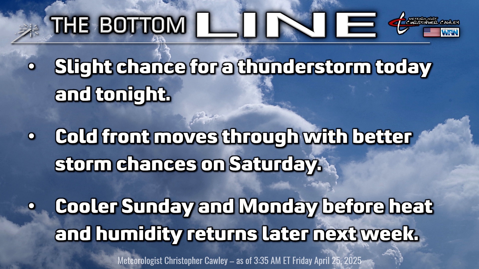
Here’s today’s Bottom Line
For several days we have been dealing with a dying frontal boundary just south of our area. This boundary triggered a few showers and storms about the area yesterday; however, none that measured any precipitation on my weather station in Whiteville.
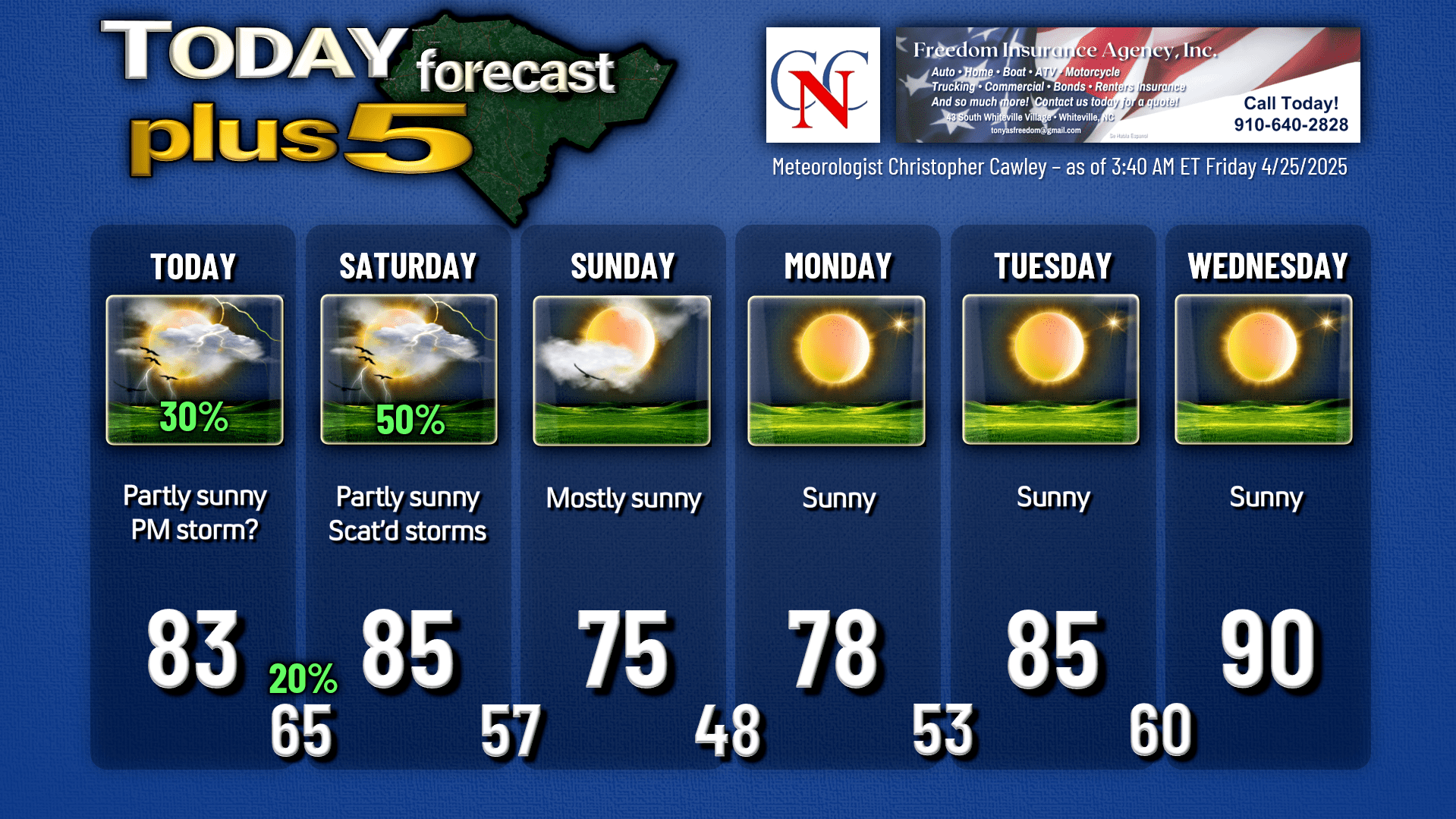
This boundary will continue to influence our weather, and really we’re going to have an exact duplicate in terms of weather conditions today… a mix of sunshine and clouds, and a few isolated or widely scattered showers and storms this afternoon. I believe we’re going to punch into some warmer air and a bit more instability, so any storm that does develop will have the potential to produce a prolific downpour along with frequent cloud-to-ground lightning. I don’t think we’re looking at any real severe risk today.
By tonight, a true southerly/southwesterly flow becomes established, which will lead to quite humid conditions and lows only dropping to the mid 60s. I’m not going to rule out a renegade shower or thunderstorm during the overnight, and I put a “20%” on the chart for tonight.
A true cold front will cross our area Saturday afternoon or early evening. Warm and humid conditions will exist ahead of this front, and a line (or more likely a BROKEN line) of showers/storms will move across the state ahead of the front. It is likely that this line will lose a lot of its dynamics throughout the day, and by the time it crosses ColCo, there’s the chance that we don’t get any rain whatsoever.
Again, any storm that does develop on Saturday will have the potential to produce gusty winds, a brief downpour, and frequent lightning.
The front pushes off the coast by Saturday night shutting off all rain chances by mid- to late-evening. Cooler air pushes in behind the front and our lows drop below 60 for the first time in quite a while.
Sunday will be an absolutely gorgeous day with mostly sunny skies, bright white fluffy cumulus clouds, and highs in the mid 70s.
Ridging high pressure will become quite sprawling, extending from the Appalachians to well offshore, which will result in very dry weather most, if not all, of next week. We’re also going to see a sharp uptick in temperatures by mid-week… with highs jumping from the upper 70s on Monday to around 90 by Wednesday. The modeling (mainly GFS) hints at a frontal passage sometime Friday (May 2nd); if this is the case we’ll see slightly cooler temps for the Strawberry Festival next weekend. It’s way too soon to make that call, especially given the fact that model guidance tends to prematurely break down these high pressure ridges.
Here is your Freedom Insurance Today-plus-Five Forecast:
That’s going to do it for today’s report. As always, thank you for reading and for supporting Columbus County News. Have a great day!
–Meteorologist Christopher Cawley