Hello friends and followers, a good day to you. It is now time for the CCN Daily Weather Update for Monday April 7, 2025. This is going to be an active weather day (and night).
This weather update is sponsored by Freedom Insurance of Whiteville. Protect what matters with Freedom Insurance. Life is full of surprises, but with Freedom Insurance, you’ll always be prepared. Whether it’s your home, car, business, or health, we provide customized coverage to keep you and your loved ones secure. Contact Freedom today at 910-640-2828!
STATISTICS FOR WHITEVILLE – Sunday April 6, 2025.
High: 90.6°F at 2:29 PM (normal is 72)
Low: 70.0°F at 1:22 AM (normal is 46)
Precip: 0.00 in
View live, real-time weather data for Whiteville on my College Street Weather Station.
Here’s today’s Bottom Line
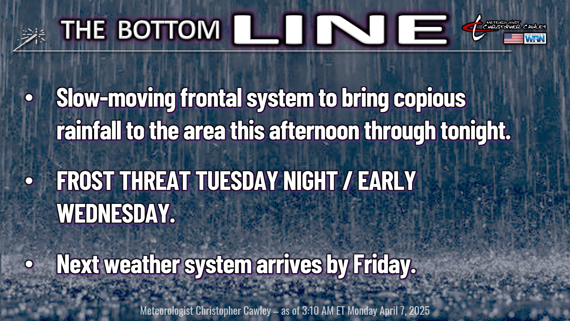
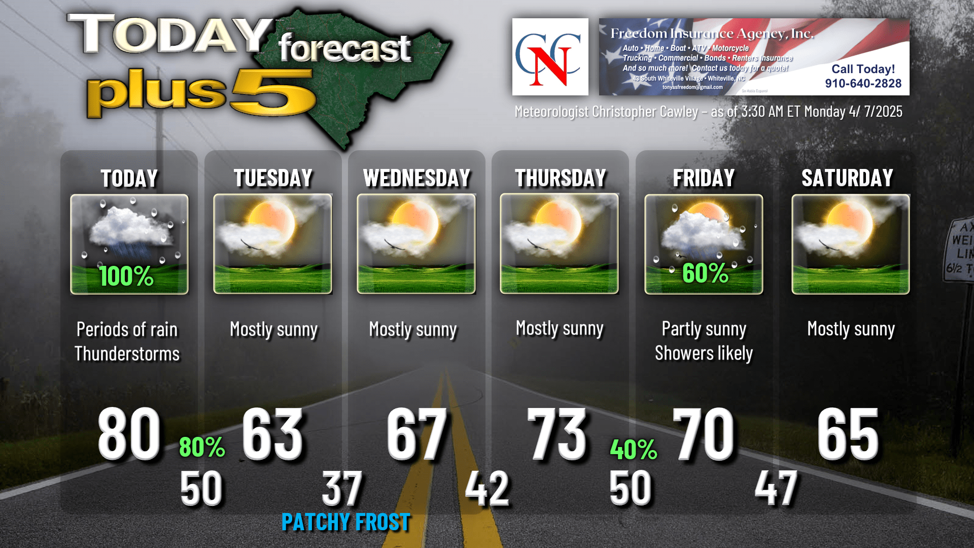
Busy weather day today as a frontal system slowly… and I sure do mean SLOWLY… approaches our area and then finally moves through this evening or tonight.
We’ll start off with breaks of sunshine and, for the most part, this morning should remain dry.
I expect a line, or more likely a broken line, of showers and thunderstorms to approach the I-95 corridor around 2 PM, and then inch its way toward ColCo during the afternoon, finally arriving here just as you’re getting ready to head home from work. At least, that’s what the latest available guidance suggests, and I see no reason to rewrite the Bible on this.
I rarely do it, but I have put the full “100%” on the forecast chart for later this afternoon. It may seem like a nice morning, and you’ll be thinking, “dude, you messed this up,” but it’s coming. I promise.
Modeling shows that the line may slow down or even stop forward progression for a short while around suppertime, which could lead to training of additional storm cells. What is meant by “training,” is that storm cells develop and repeatedly move over the same area, like cars on a train. This could lead to localized flooding concerns. There is no way to predict whether or not this stoppage in forward movement happens.
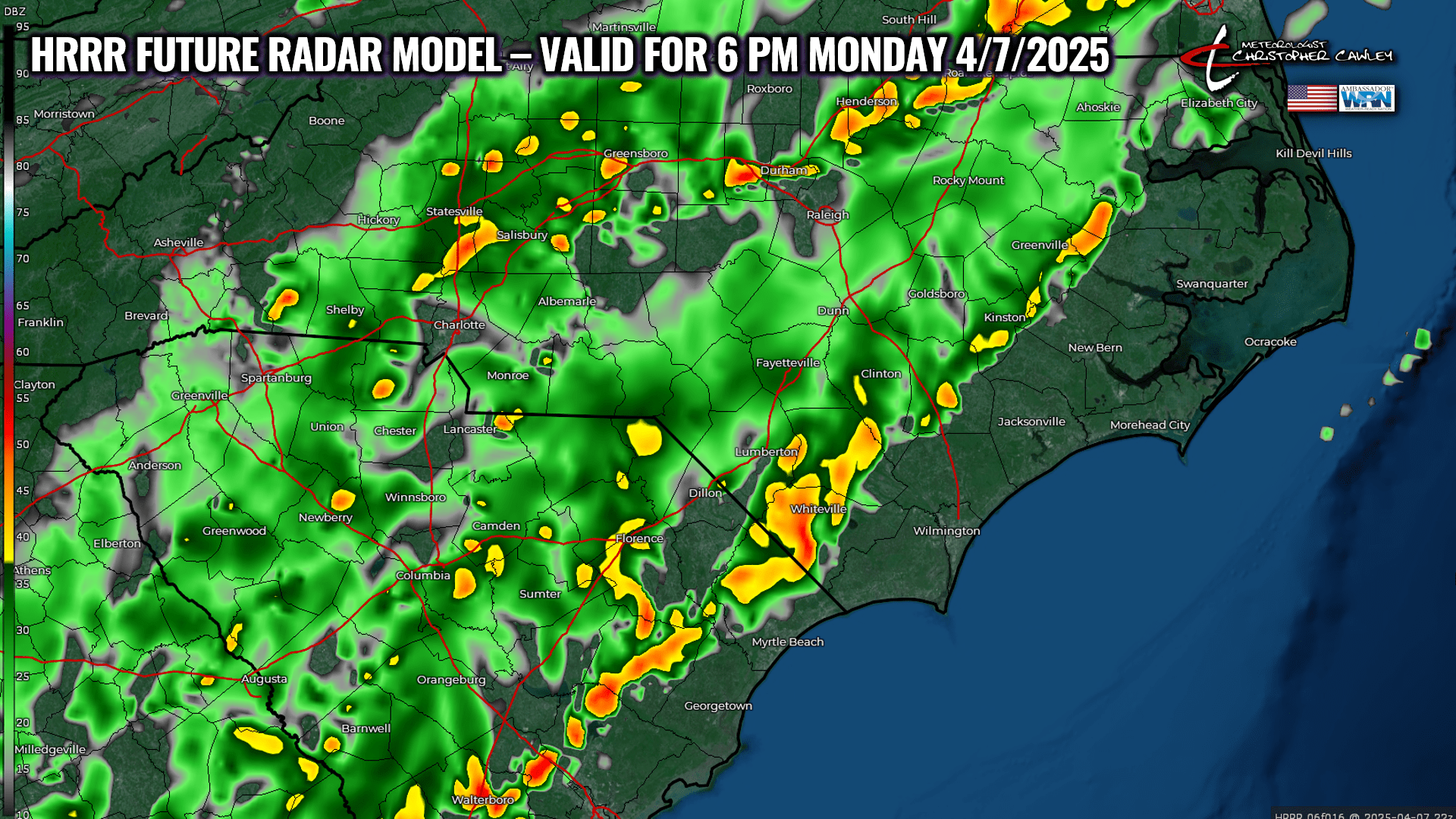
Periods of rain and thunderstorms will continue through the evening hours as significant moisture continues to pump northeast over the area ahead of the actual front, which should clear the coast sometime around midnight.
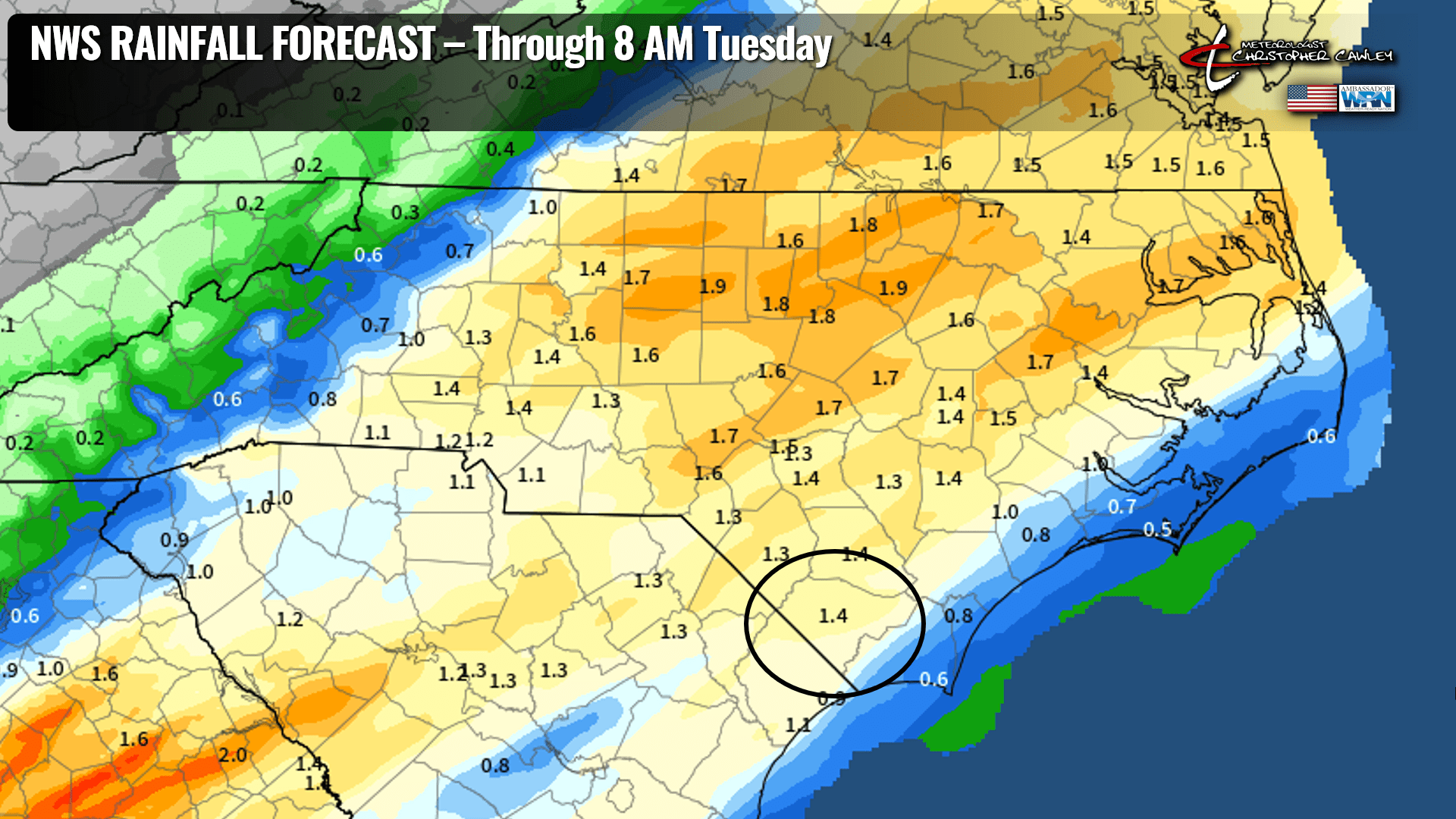
Storm total rainfall between 1 and 2 inches is expected. The latest NWS outlook calls for 1.4 inches (average) in the Whiteville area and I don’t really see any reason to disagree with that. The National Blend of Models paints 1.5, so that’s that.
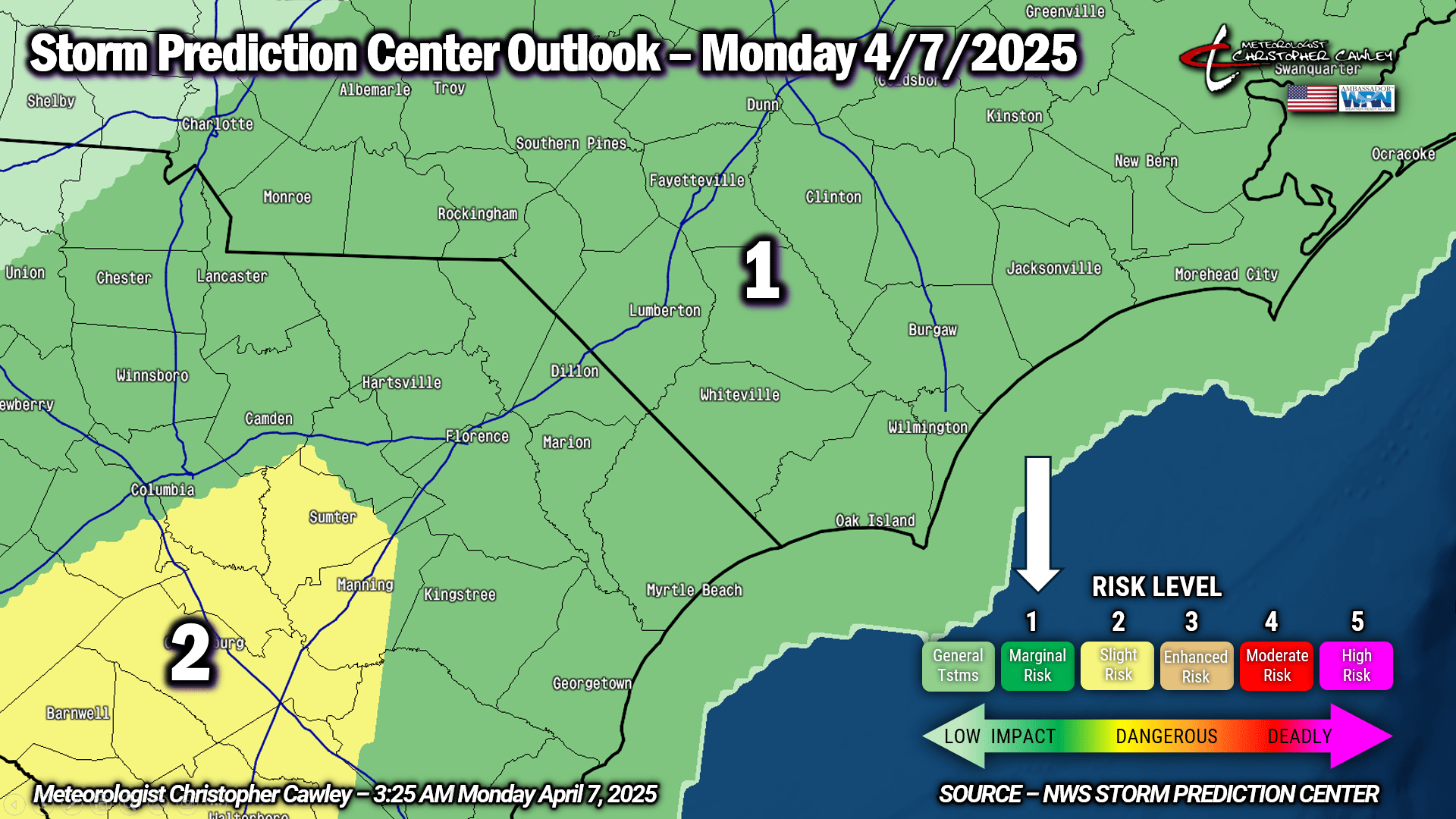
There is a marginal risk for severe weather as this line (or broken line) moves over the area this afternoon. The primary risk is for a damaging wind gust or two to “mix down” to the surface, thanks to a fairly robust low-level jet and decent instability over the area. NAM guidance also hints at a non-zero tornado risk, but again, that threat is very isolated. I don’t disagree with the model as the ingredients are there, but I don’t foresee a significant severe risk today.
Once the front clears the area, the precipitation stops and skies clear out toward daybreak. A secondary frontal boundary whisks over the area ushering in high pressure of Canadian origin for the midweek period.
** FROST POTENTIAL LATE TUESDAY NIGHT **
The center of that cold, Canadian high will be just to our north on Tuesday night into early Wednesday. This will result in almost perfect radiational cooling conditions. I expect widespread lows in the 30s away from the beaches, including ColCo. I’m putting a “37” on the chart for Whiteville but outlying areas, typically colder spots, will likely drop to between 34 and 37 degrees. At least patchy frost is likely to occur; however, exceptionally dry air in place should limit the overall spread. I don’t anticipate any temps dropping below the freezing mark locally.
Temperatures on Wednesday will run about 5-8 degrees below normal for this time of year. The high slips off the coast by Wednesday night, so we won’t be as cold… and Thursday should feature temps back to where they should be.
Our next frontal system takes aim on the area for late Thursday night through Friday with the likelihood of showers and maybe some thunder. Temperatures dip back below normal for the weekend, but at this point there’s no frost threat at all.
Here’s your Freedom Insurance Today-plus-Five forecast:
That will conclude today’s report. Thanks for your time, and as always, take care!
~CCN Meteorologist Christopher Cawley