Hello everyone, and good day to you! Here is your CCN Weather update for Good Monday April 21, 2025.
This weather update is sponsored by Freedom Insurance of Whiteville. Protect what matters most with Freedom Insurance. Life can be full of surprises, but with Freedom Insurance, you will always be prepared. Whether it’s your home, car, business, or health, we provide customized coverage to keep you and your family safe. Contact Freedom today at 910-640-2828!
STATISTICS for Sunday 4/20/2025
High: 87.7°F at 4:33 PM (Normal 76)
Low: 60.9°F at 6:42 AM (Normal 50)
Precip: 0.00 IN
View real-time data from the weather station at College Street Weather Station.
Here’s today’s Bottom Line
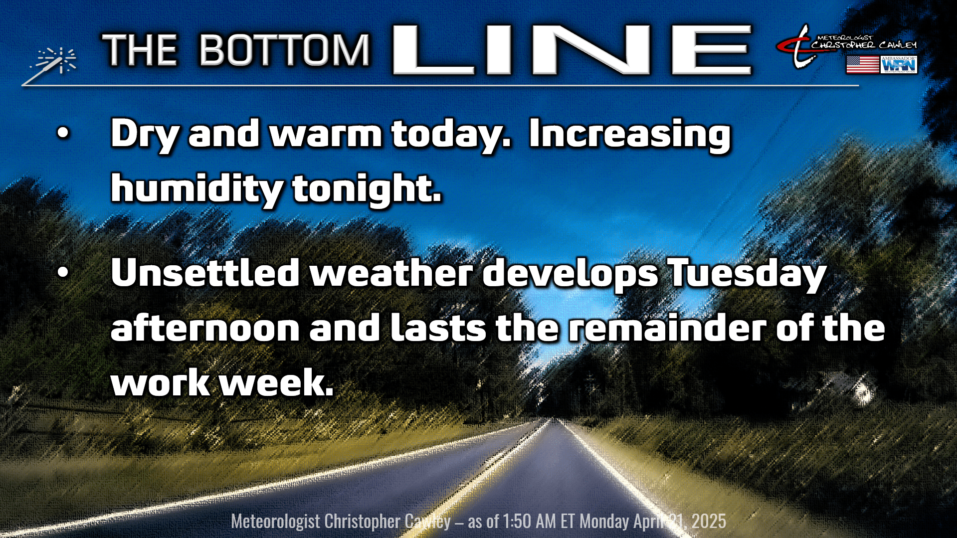
It has definitely been a minute since we’ve had some rainfall across the county, and that will probably change this week. No guarantees for everyone though.
The high pressure ridge responsible for our dry weather over the past week will hang on for one more day before a frontal system will begin to break down that ridge.
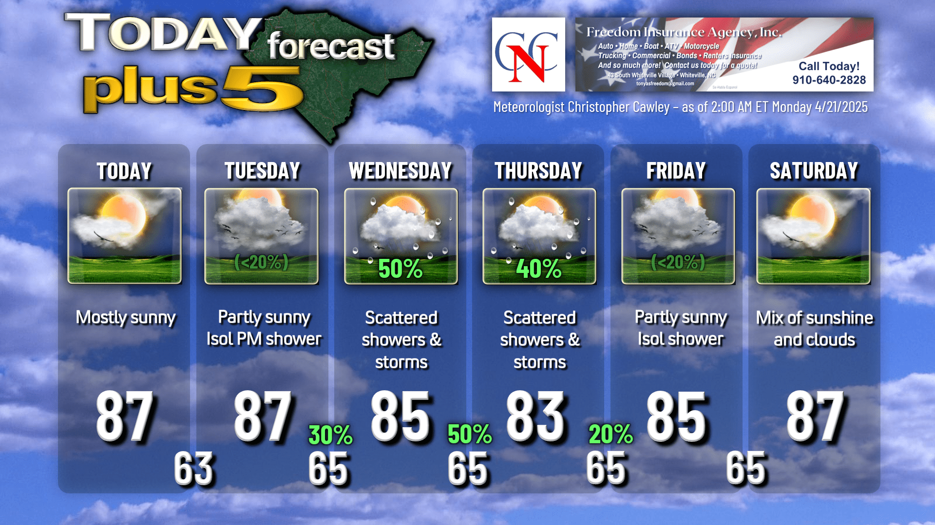
A little bit of low clouds and/or fog this morning should burn off very quickly, giving us mostly sunny skies for today and highs generally in the mid to upper 80s. The humidity creeps back up tonight as clouds start to push in from the west.
Your Tuesday will feature a mix of sunshine and clouds as we enter a transition between the high pressure offshore, another area of high pressure over southern Georgia, and the frontal system trying to approach from the northwest. The vast majority of the day will be dry on Tuesday, but I can’t rule out an isolated shower or thunderstorm in the afternoon as a frontal boundary lies across the TN/NC border area.
A “cold front” drops down from the north on Wednesday and becomes slung out west-to-east along the NC/SC line, or perhaps just a little farther south as high pressure nudges down over upstate New York. The frontal boundary gets caught up in the westerly flow between highs to our north and south and kind of “washes out” over the area during the Tuesday night through Thursday night period, bringing variably cloudy skies along with the threat for scattered showers and thunderstorms.
The key word is SCATTERED. The showers/storms will be of the “hit or miss” variety. Not everyone will see rainfall this week, and a few isolated spots may actually get a significant amount of rainfall, it just depends on where the SCATTERED showers and storms become established. There’s certainly not an organized severe threat to worry about, but any localized storm could produce a quick downpour and a good bit of lightning.
Temperatures will be remarkably consistent this week… upper 80s today and tomorrow drop to the mid 80s for the Wednesday-Friday period, back to the upper 80s on Saturday. Lows are going to be reliably in the lower to middle 60s through the week.
High pressure to our south becomes reestablished as we head into Friday and Saturday. An isolated shower or storm is possible Friday, but I think most of the time we’re going to be dry. Saturday we’re in a “warm sector” as high pressure over southern Georgia strengthens a little bit ahead of the next cold front (a real cold front).
The front looks to move through here late Saturday through Sunday with a much better likelihood for showers and thunderstorms, and slightly cooler temps (closer to seasonable normal values) going into NEXT week.
So, in short, keep an umbrella handy from Tuesday afternoon through Thursday evening. No drought-busting rainfall, nothing significant, but every drop counts at this point.
Here is your Freedom Insurance Today-plus-Five Forecast:
That’s going to do it for today’s report. As always, thank you for reading and for supporting Columbus County News. Have a great day!
–Meteorologist Christopher Cawley