Hello friends and followers, a good day to you. It is now time for the CCN Daily Weather Update for Wednesday April 9, 2025.
This weather report is brought to you by Freedom Insurance of Whiteville. Safeguard what is important with Freedom Insurance. Life can be unpredictable, but with Freedom Insurance, you will always be ready. Whether it’s your home, vehicle, business, or health, we offer tailored coverage to ensure you and your family are protected. Reach out to Freedom today at 910-640-2828!
STATISTICS FOR WHITEVILLE will be unavailable until further notice. The computer which hosted my weather station (among numerous other things) suffered a catastrophic failure on Tuesday, rendering it nothing more than a box of plastic, metal, and wires. We had a funeral service, it was beautiful, you should have been there. In all seriousness, this is a setback for me but it’ll be okay. Fear not! Your daily weather update shall continue uninterrupted.
Here’s today’s Bottom Line
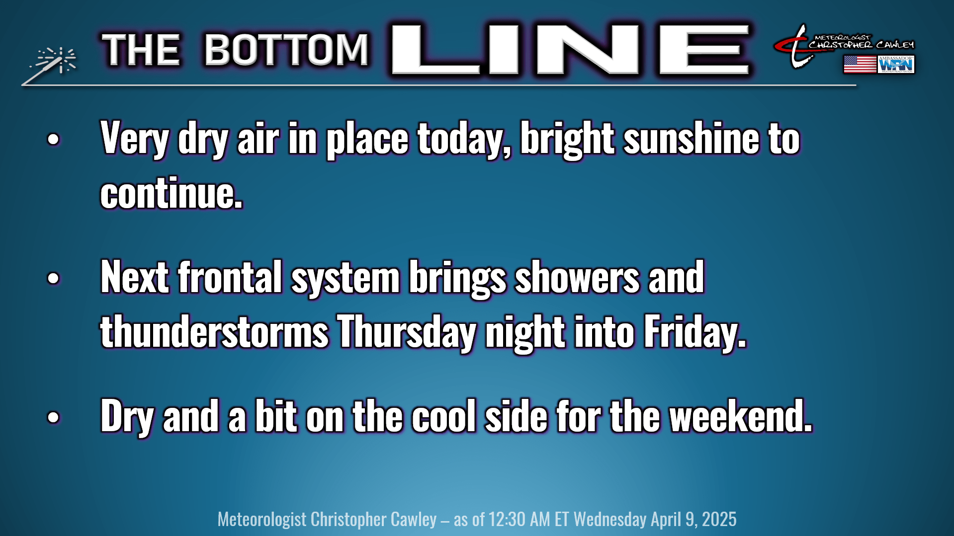
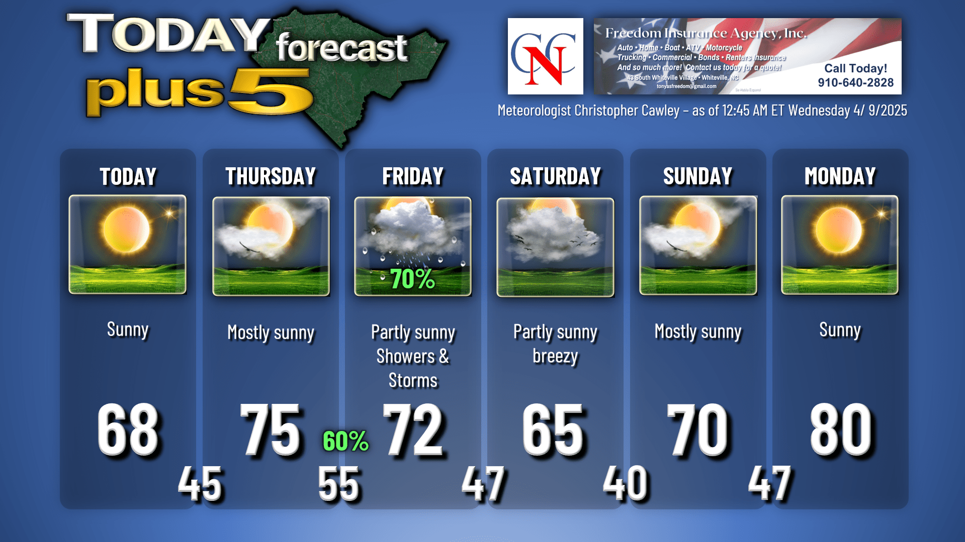
Dry high pressure, and it certainly is dry, will traverse slowly over the area today, eventually moving offshore tonight. Temperatures will remain a little bit below seasonal norms — I think we’ll top off in the upper 60s across the county, with bright sunny skies. The air is going to be very dry indeed, with dewpoint values in the 30s this afternoon, resulting in a humidity value in the 20% to 30% range.
The high is fully offshore by Thursday, resulting in a southerly flow of warmer and more humid air from the Gulf. This will bring our temperatures back up to about where they should be. I’m expecting mostly sunny skies on the whole for Thursday, but clouds should start increasing late in the day ahead of our next weather system.
All eyes then turn to the Thursday night – through – Friday period for our next chance for rain and thunder. It’s going to sound worse than it’ll really be, when listening to my forecast on the radio. I believe we’ll have a good coverage of SCATTERED showers and thunderstorms through the period. No severe weather is anticipated, though there will be some instability in place, enough to cause separation of charges in our atmosphere resulting in electrical discharge, known as lightning. Rainfall should be on the order of about half an inch, just judging by previous storm systems of similar character.
That’s all a memory by the weekend, but a northeasterly flow sets up a brief episode of the infamous Carolina Cold Air Damming scenarios, commonly known as a wedge. This occurs on Saturday where we will experience more clouds than sunshine, rather chilly temps, and a northeasterly breeze off the ocean. While we should remain dry, it probably isn’t going to be the nicest of days. Nicer weather returns Sunday, and then our temps jump back to the 80s as we head into next week.
Here is your Freedom Insurance Today-plus-Five forecast:
That’ll put a bowtie on today’s report, ladies and gents. Thank you for your time, and as always, take care!
~Meteorologist Christopher Cawley.