Hello everyone and good day to you! Welcome to the CCN Weather Update for TGIF, Friday May 16, 2025.
This weather update is sponsored by Freedom Insurance of Whiteville. When severe weather strikes, with Freedom Insurance you will always be prepared. For home, car, boat, or whatever you need, Freedom can provide customized coverage to keep you and your family safe. Contact Freedom today at 910-640-2828!
STATISTICS for Thursday 5/15/2025
High: 90.8°F at 3:14 PM (Normal 80)
Low: 66.1°F at 4:04 AM (Normal 57)
Precip: 0.00 in
Precip – Month: 6.37 in
View real-time data from the weather station at College Street Weather Station.
Here’s today’s Bottom Line
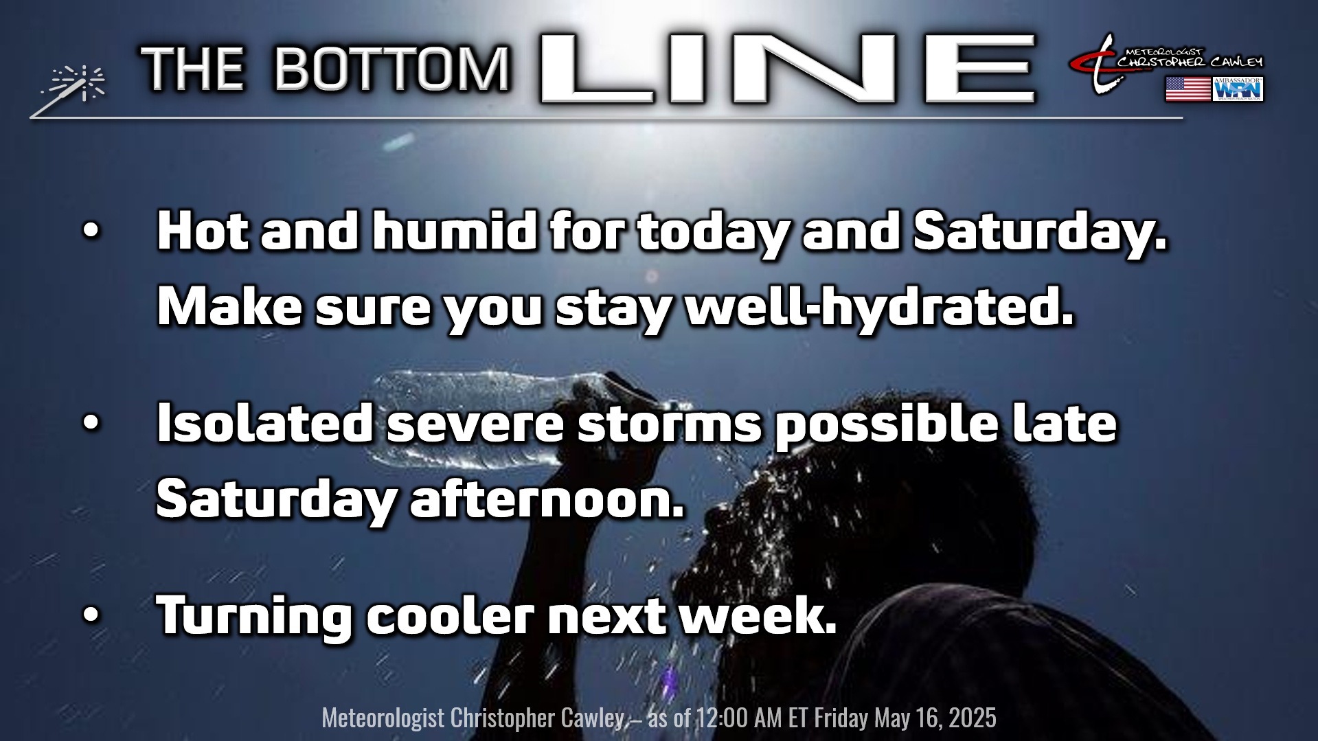
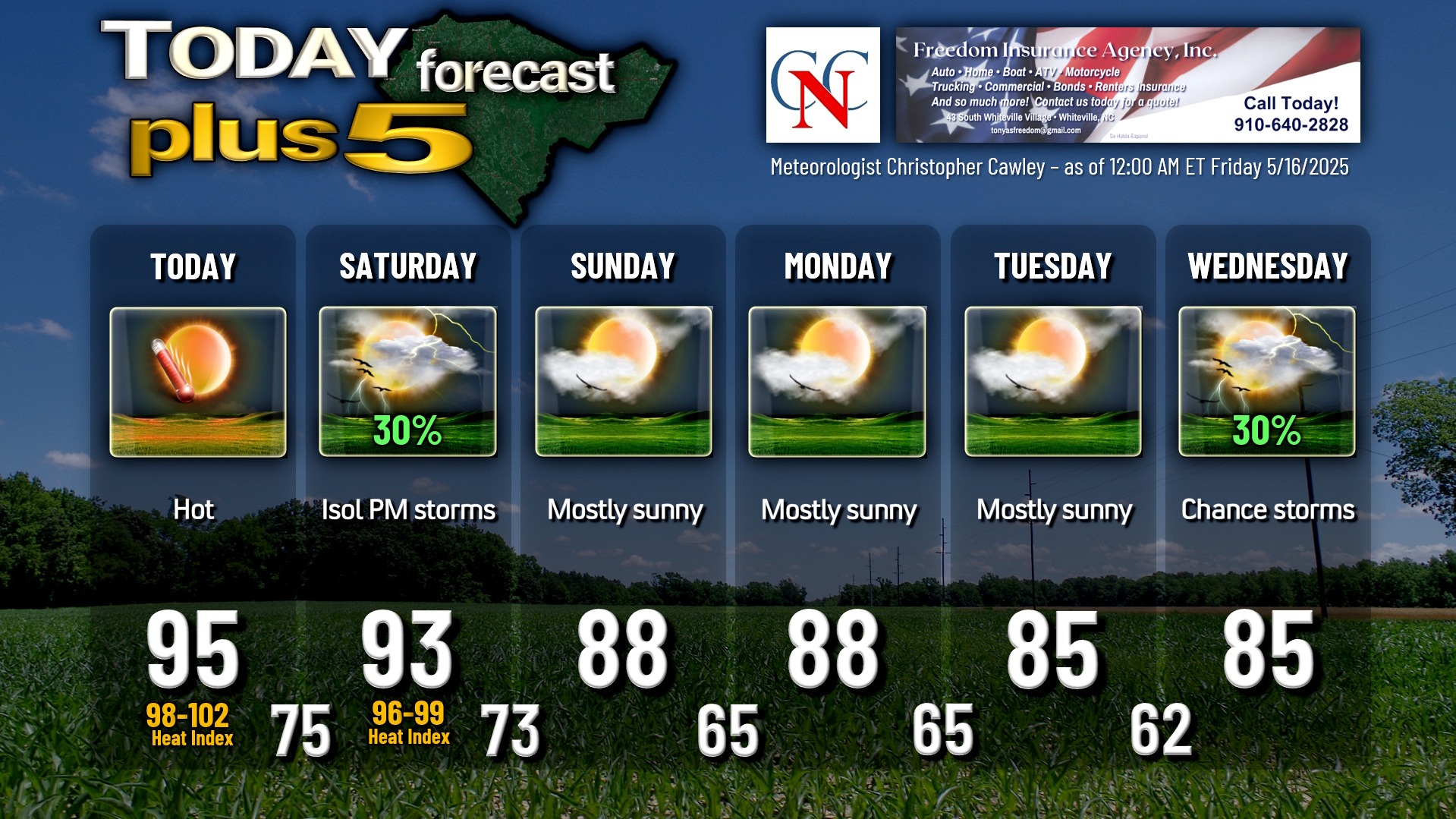
We’ll be approaching… if not breaking… record highs across the county today. I’m going with a 95 for the high, but when you factor in fairly high relative humidity values, heat index values will crest the Misery Mark of 100°F. Since this is the first true heat wave of the season, it is important to remember that one of the top weather-related killers is actually exposure to heat. The NWS hasn’t issued any advisories as of the time of this writing. The NWS criteria for a “heat advisory” is a heat index of 105 to 109 for 3 consecutive hours or longer. We’re not going to reach that today.
There will be little in the way of cloudiness today, and I don’t expect any thunderstorm activity. That isn’t to say that one might not pop up on the sea-breeze boundary, but I highly doubt it.
A weak cold front will drop down over the area by Saturday night. We’ll have a bit more in the way of cumulus clouds in the sky on Saturday, and those may develop into cumulonimbus clouds and thunderstorms. There is the chance that whatever storms DO form on Saturday afternoon may produce very large hail and some damaging winds. The coverage is expected to be widely scattered at worst (as of this writing)… definitely not a washout. Saturday will once again feature highs in the lower 90s with heat index values flirting with 100.
Above-normal temperatures will continue through Monday before dropping back closer to seasonal normal values for the mid-week period. Our weather will be dry Sunday through Tuesday, but our next frontal system takes aim on ColCo by Wednesday. There is quite a bit of uncertainty within the model guidance on how things play out toward the middle of next week, so for now I put a thunderstorm icon and “30%” on the graphic below. That will likely get tweaked as we get closer in time. Longer-range modeling points to cooler-than-normal temps (highs in the 70s!) by the end of next week (May 22nd-23rd).
Here is your Freedom Insurance Today-plus-Five Forecast:
That’s going to do it for today’s report. As always, thank you for reading and for supporting Columbus County News. Have a great day!
–Meteorologist Christopher Cawley