Greetings friends and neighbors, and good day to you! Welcome to the CCN Weather Update for Saturday May 3, 2025.
This weather update is sponsored by Freedom Insurance of Whiteville. Protect what matters most with Freedom Insurance. Life can be full of surprises, but with Freedom Insurance, you will always be prepared. Whether it’s your home, car, business, or health, we provide customized coverage to keep you and your family safe. Contact Freedom today at 910-640-2828!
STATISTICS for Friday 5/2/2025
High: 88.0°F at 2:39 PM (Normal 79)
Low: 64.1°F at 6:11 AM (Normal 56)
Precip: 0.00 om
View real-time data from the weather station at College Street Weather Station.
Here’s today’s Bottom Line
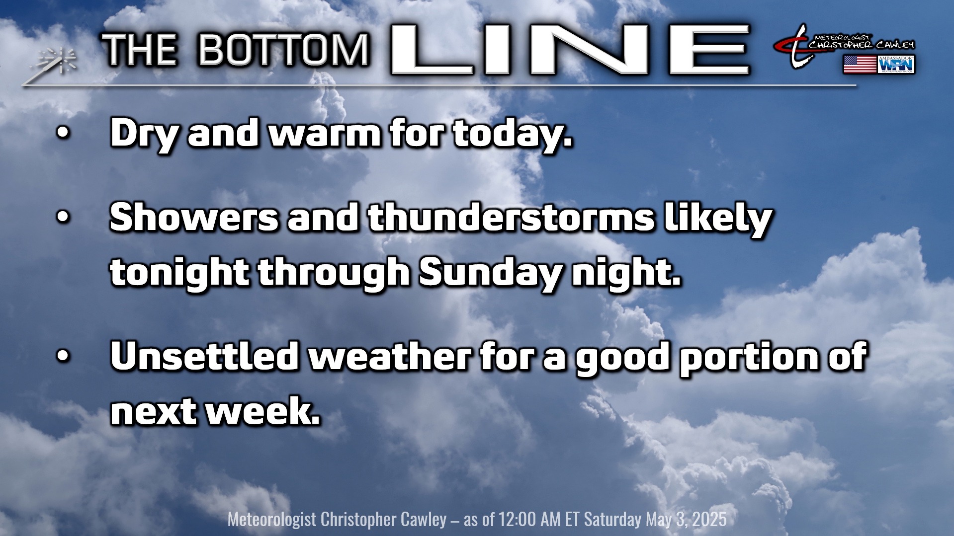
A slow-moving frontal system will approach and move over the area by late tonight. This front will then likely stall along or just inland from the coast, lasting into next week.
Today should be mostly dry. Model guidance suggests that we’ll remain completely dry today but I just can’t rule out a spotty shower or thunderstorm this afternoon. If you’re headed to Chadbourn this morning for the Strawberry Festival, I believe the weather will be completely fine, but bring an umbrella just in case.
Shower and thunderstorm chances ramp up starting tonight. A surge of moisture will move in from the south, and combine with the frontal boundary. Current model data suggests between one-half and one-inch of rainfall for the county during the overnight hours. There may be a lull in the activity Sunday before scattered to numerous showers and thunderstorms develop again Sunday afternoon and evening. Instability looks pretty good Sunday afternoon, and that, combined with elevated shear values, points to a low-end severe risk for Sunday afternoon and evening.
There is an extraordinary level of uncertainty in the forecast going into next week. A “stacked” “cut off low” (definitions in a moment) over the Ohio valley will slowly move across the northeast U.S. into the midweek period, while a second low pushes to our south. At the surface, the frontal boundary from Sunday night will get hung up around the coast thanks to the low wobbling over the northeast.
(A stacked low is one in which there is low pressure at the surface, another “low pressure” at about 5,000-10,000 feet, and another one between 18,000-20,000 feet. These are “stacked,” like pancakes. A “cut off low” is one that is basically cut off from the atmospheric flow. Cut off lows are also known as “closed lows” and tend to just wobble over the same general area, sometimes for days at a time.)
Anyway… with this frontal boundary in the area and that cut off low over the northeast, I can’t promise completely dry weather any day next week. Unsettled conditions with “popcorn convection” (scattered showers/storms) are likely for Monday afternoon; this trend may (or may not) continue Tuesday. The rest of the week’s conditions will depend largely on the position of the front and moisture availability. The National Blend of Models shows a very wide range of rain chances for the back half of the work week.
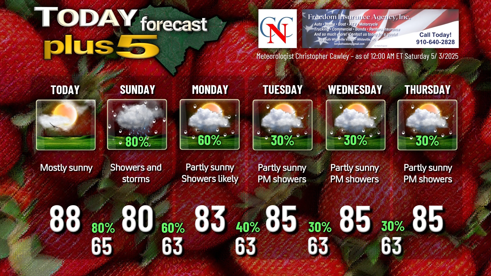
Not only do I have a higher-than-normal level of uncertainty with regard to rain chances, but the same exists with temperatures. Temperatures could vary by as much as 10 degrees depending on the placement of the front. For now I’m going with generally mid 80s by day and lower 60s by night through the week, but that’s highly subject to change.
Here is your Freedom Insurance Today-plus-Five Forecast:
That’s going to do it for today’s report. As always, thank you for reading and for supporting Columbus County News. Have a great day!
–Meteorologist Christopher Cawley