Hello friends and neighbors, and good day to you! Welcome to the CCN Weather Update for Thursday May 29, 2025.
This weather update is sponsored by Freedom Insurance of Whiteville. When severe weather strikes, with Freedom Insurance you will always be prepared. For home, car, boat, or whatever you need, Freedom can provide customized coverage to keep you and your family safe. Contact Freedom today at 910-640-2828!
STATISTICS for Wednesday 5/28/2025
High: 84.8°F at 5:20 PM (Normal 83)
Low: 65.1°F at 12:05 AM (Normal 61)
Precip: 0.02 in
Precip – Month: 7.17 in
View real-time data from the weather station at College Street Weather Station.
Here’s today’s Bottom Line
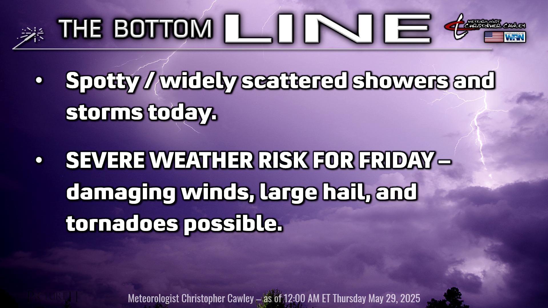
Yesterday’s forecast is what we call a world-class “bust.” But in a good way, I suppose, since I called for clouds, showers, and storms, and in actuality we had a pretty nice day in the end. It is what it is.
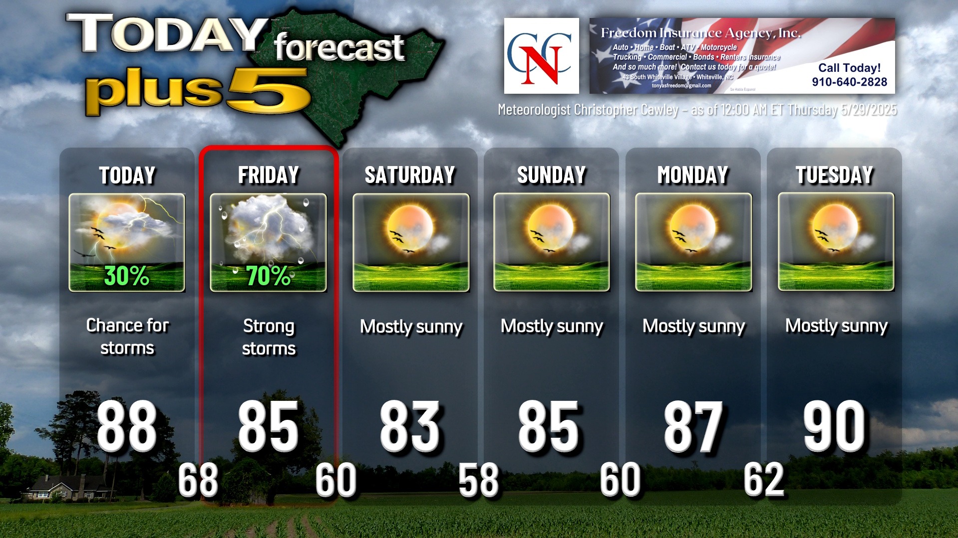
Today our area is firmly in the warm sector of a fairly complex storm system. A warm front has lifted well north of the area. A cold front, a strong one, will push through the area late Friday.
Today will be warm and humid with what I believe will be a good amount of sunshine. It’s a difficult forecast, given the remarkable instability that will be present, because isolated to widely scattered thunderstorms are probable in the moist environment, and they could develop at any point in time and at any location. Who gets what is impossible to predict, and it may turn out that we remain rain-free for the entire area. Overall severe threat for today is low given the lack of shear… storms won’t have any real “organization” to them, no rhyme-nor-reason, so to speak. Any storm that does form will drop Biblical rainfall for a short period of time.
WEATHER ACTION DAY FOR FRIDAY… SEVERE WEATHER POTENTIAL
Friday, on the other hand, is our WEATHER ACTION DAY. Plenty of sunshine is expected through Friday morning. This opens a huge window of concern for severe weather Friday afternoon through late evening. Once the sunshine gets underway, there will be all kinds of instability available Friday afternoon and evening. In addition, our wind profiles will be strengthening throughout the day as the strong cold front approaches from the west. Shear numbers become rather eye-popping in the afternoon, supporting organized strong to severe thunderstorm activity. Individual storms probably develop Friday afternoon, and they may become supercells if they can interact with the strong shear. Supercell thunderstorms bring a tornado threat.
Then the main event occurs, as a convective line is likely to develop just ahead of the cold front. This should cross the county during Friday evening. At this time, all modes of severe weather are possible, including damaging (possibly destructive) straight-line winds, large hail, and isolated tornadoes. The NWS Storm Prediction Center has placed our area under a level 2 out of 5 risk for severe weather on Friday.
The front moves offshore Friday night, and much cooler air rapidly pushes into the county. We wake up Saturday morning with temps right around 60°F. A second (much weaker) cold front moves through Saturday but I really don’t think we’re going to notice anything with that… my forecast is for mostly sunny skies. It will be rather breezy, but temps will top off in the lower 80s, which, for the end of May, is a win. Temps drop into the upper 50s by early Sunday morning.
Sunny/dry conditions prevail into next week with steadily increasing daytime highs, and steadily increasing humidity. Welcome to the month of June, and welcome to summer.
TROPICAL WEATHER FORECASTS are returning Sunday June 1st, the official start of hurricane season.
Here is your Freedom Insurance Today-plus-Five Forecast:
That’s going to do it for today’s report. As always, thank you for reading and for supporting Columbus County News. Have a great day!
–Meteorologist Christopher Cawley