


Greetings readers, good day to you! Welcome to the CCN Weather Update for Thursday May 8, 2025.
This weather update is sponsored by Freedom Insurance of Whiteville. Protect what matters most with Freedom Insurance. Life can be full of surprises, but with Freedom Insurance, you will always be prepared. Whether it’s your home, car, business, or health, we provide customized coverage to keep you and your family safe. Contact Freedom today at 910-640-2828!
STATISTICS for Wednesday 5/7/2025
High: 85.9°F at 1:00 PM (Normal 81)
Low: 58.7°F at 6:59 AM (Normal 58)
Precip: Trace
View real-time data from the weather station at College Street Weather Station.
Here’s today’s Bottom Line
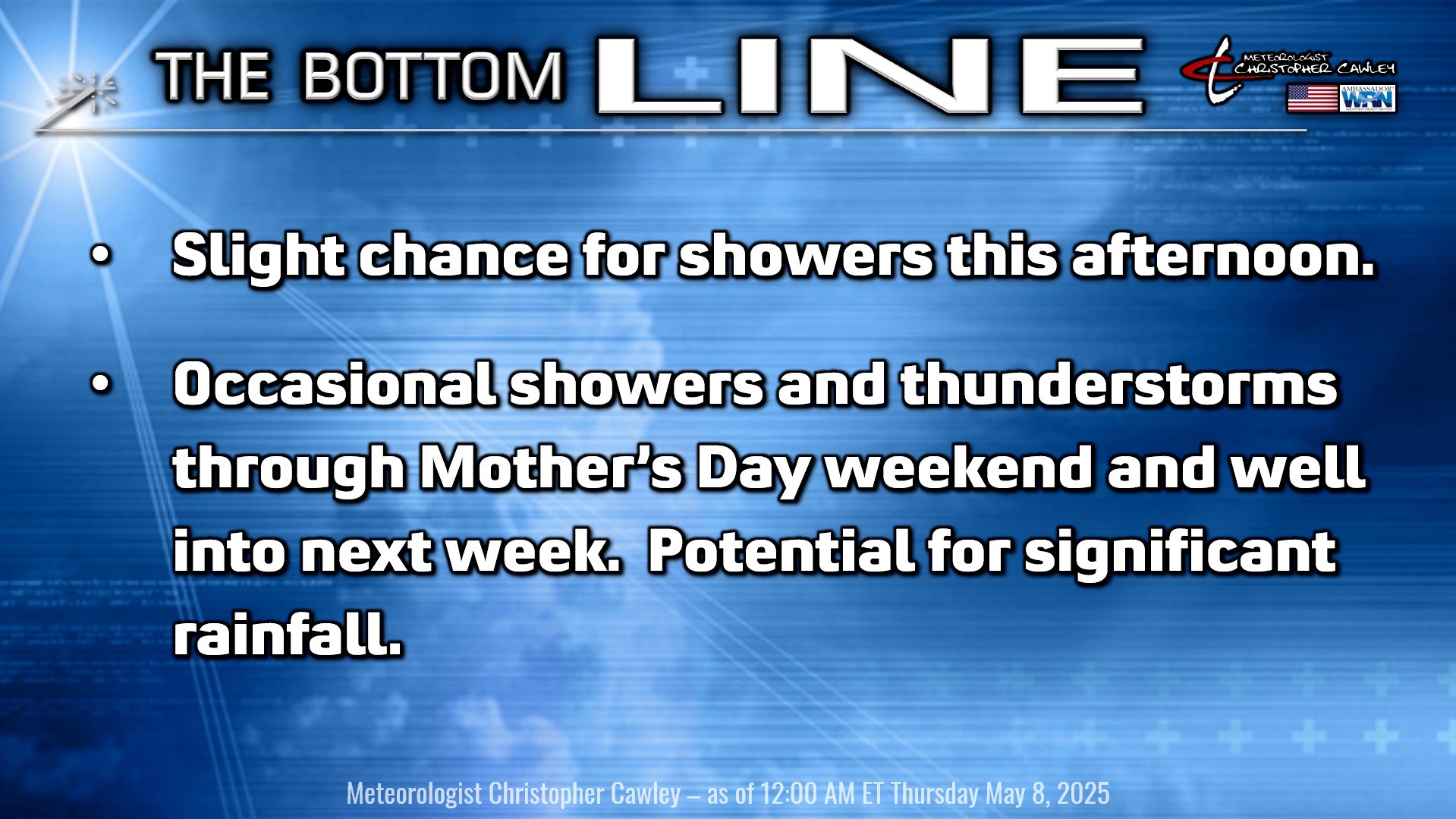
** SIGNIFICANT RAINFALL POSSIBLE OVER THE NEXT 7 DAYS **
Blended models point to much of Columbus County receiving between 4 and 6 inches of rainfall between now and 8 AM next Wednesday (May 14th).
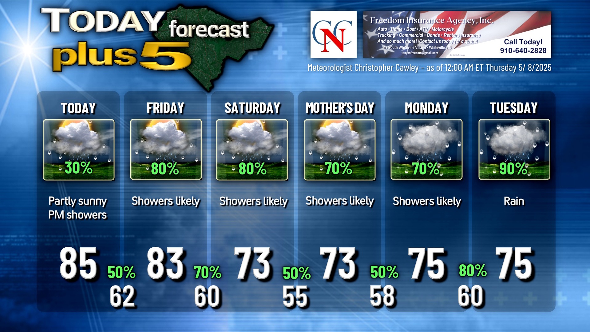
Today will feature a mix of sun and clouds with showers possible this afternoon. A southwesterly flow will bring very moist air into our area. The showers are expected to be scattered in nature.
A cold front slowly drops southeast over the area through Friday into Friday night. The front will get hung up along the I-95 corridor, and low pressure starts to organize over Alabama by late Friday night.
The low moves to the coast by Saturday evening and moves north and east offshore through Mother’s Day. The frontal boundary remains in place through southern Georgia and southern SC, and along the coast. This leads to another, stronger wave of low pressure developing over the northern Gulf coast. This low lifts slowly northward over Alabama through Monday, then through central South Carolina on Tuesday, and off the North Carolina coast by next Wednesday. This low will bring the potential for significant rainfall early next week.
This could be the drought-buster we’ve been waiting for.
As mentioned at the top of the post, the model blends are calling for between 4-6 inches of rainfall in total through early Wednesday the 14th. Some of the European ensemble members are pushing 7 to almost 9 inches of rainfall; the highest value on the latest runs is 8.7 inches. The highest of the GFS ensembles range in the 5-6 inch range. So the model blend makes sense — the stage is set for our drought to come to an end. Nothing is 100% certain, though, so …
Temperatures will fall to below normal values for the Mother’s Day weekend as the cold front pushes through. Temps become tricky going into next week, but I think with the clouds and rain in place, I’m going with mid 70s by day with around 60 for lows… and I can fine-tune that as we get closer in time.
Here is your Freedom Insurance Today-plus-Five Forecast:
That’s going to do it for today’s report. As always, thank you for reading and for supporting Columbus County News. Have a great day!
–Meteorologist Christopher Cawley


