Hello friends and neighbors, and good day to you! Welcome to the CCN Weather Update for Wednesday May 28, 2025.
This weather update is sponsored by Freedom Insurance of Whiteville. When severe weather strikes, with Freedom Insurance you will always be prepared. For home, car, boat, or whatever you need, Freedom can provide customized coverage to keep you and your family safe. Contact Freedom today at 910-640-2828!
STATISTICS for Tuesday 5/27/2025
High: 72.0°F at 3:51 PM (Normal 83)
Low: 60.6°F at 4:40 AM (Normal 61)
Precip: 0.76 in
Precip – Month: 7.15 in
View real-time data from the weather station at College Street Weather Station.
Here’s today’s Bottom Line
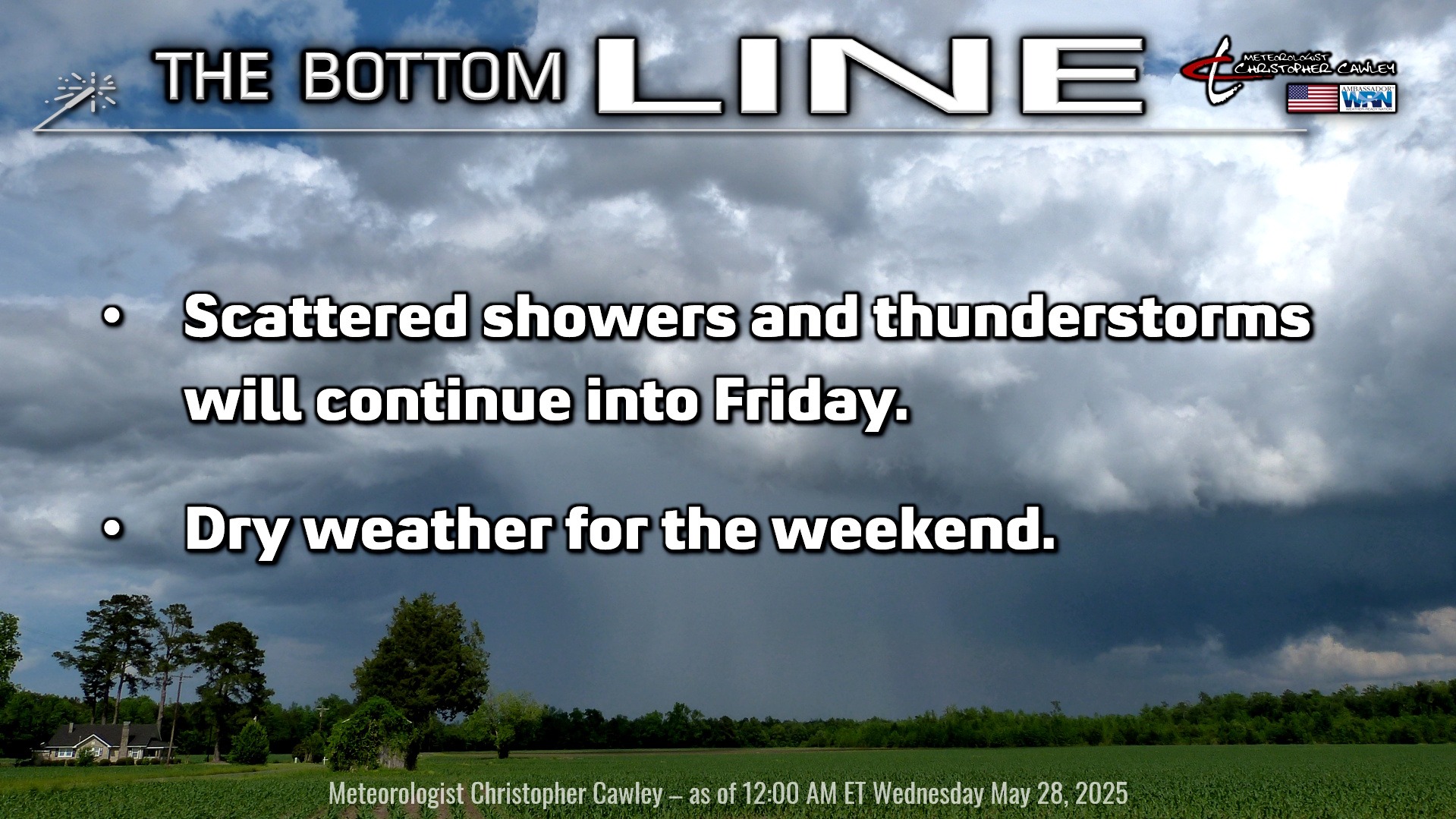
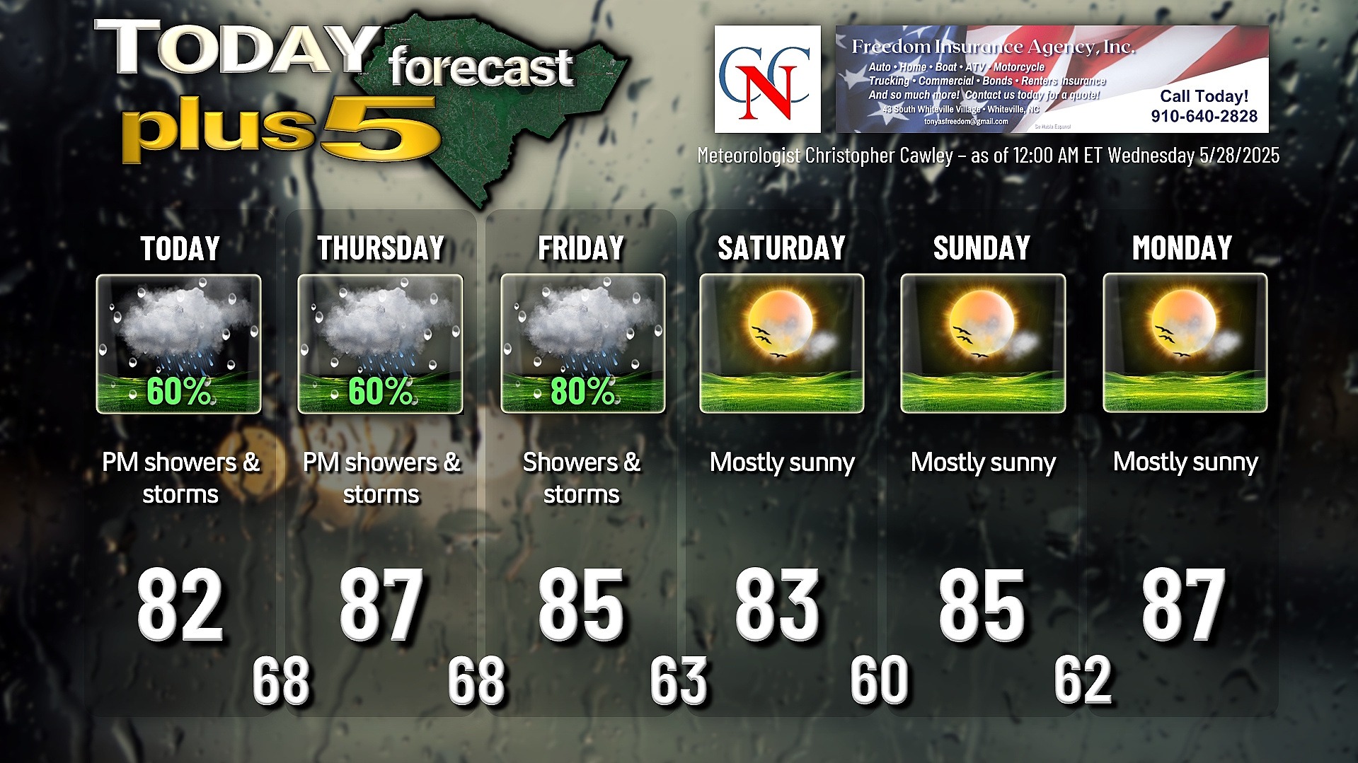
A warm front will lift from south to north this afternoon and bring the potential for showers and thunderstorms to the area ahead of the front. There should be some breaks of sunshine across the area this morning, which will increase the available instability for the frontal passage. I don’t think we’ll see any severe weather, but any storm that develops will have the potential to produce intense rainfall and gusty winds.
An area of low pressure will be moving northeast along the coast by tonight. We’re firmly in a warm sector for Thursday and head of a rather strong cold front for this time of year. We’ll start off dry, with periods of sunshine, once again pumping up our instability parameters. Rain chances increase during the afternoon as deep moisture moves in from the southwest. Scattered showers and thunderstorms are once again likely, and again, any storm that develops could produce a significant bit of rainfall in a short period of time.
For Friday, I’m considering a “weather action day,” and it will be by far the most active day for this week. Plenty of moisture and instability in the warm sector ahead of the aforementioned cold front will support scattered to widespread thunderstorms during the day. Severe weather is possible on Friday due to some pretty good shear values; if we an have some sunny periods Friday morning, that will only add to the instability that will already be in place. The NWS Storm Prediction Center has our area in a level-2 “slight” risk for severe storms on Friday. Bust potential for Friday is cloudiness… if we stay cloudy all morning, scattered showers/storms are still expected but no severe weather. The more sunshine we get, the higher the severe chance.
The front clears the coast Friday night and we will have a beautiful weekend weather-wise. Cooler and less humid conditions with plenty of sunshine for Saturday. Temps push back to “normal” values for the first of June by Sunday and Monday, but humidity should remain in check.
TROPICAL WEATHER FORECASTS are returning Sunday June 1st, the official start of hurricane season.
Here is your Freedom Insurance Today-plus-Five Forecast:
That’s going to do it for today’s report. As always, thank you for reading and for supporting Columbus County News. Have a great day!
–Meteorologist Christopher Cawley