CCN Weather Update for Saturday August 9, 2025.
This weather update is sponsored by Freedom Insurance of Whiteville. No weather worries with Freedom Insurance. For home, car, boat, or whatever you need, Freedom can provide customized coverage to keep you and your family safe. Contact Freedom today at 910-640-2828!
Here’s today’s Bottom Line
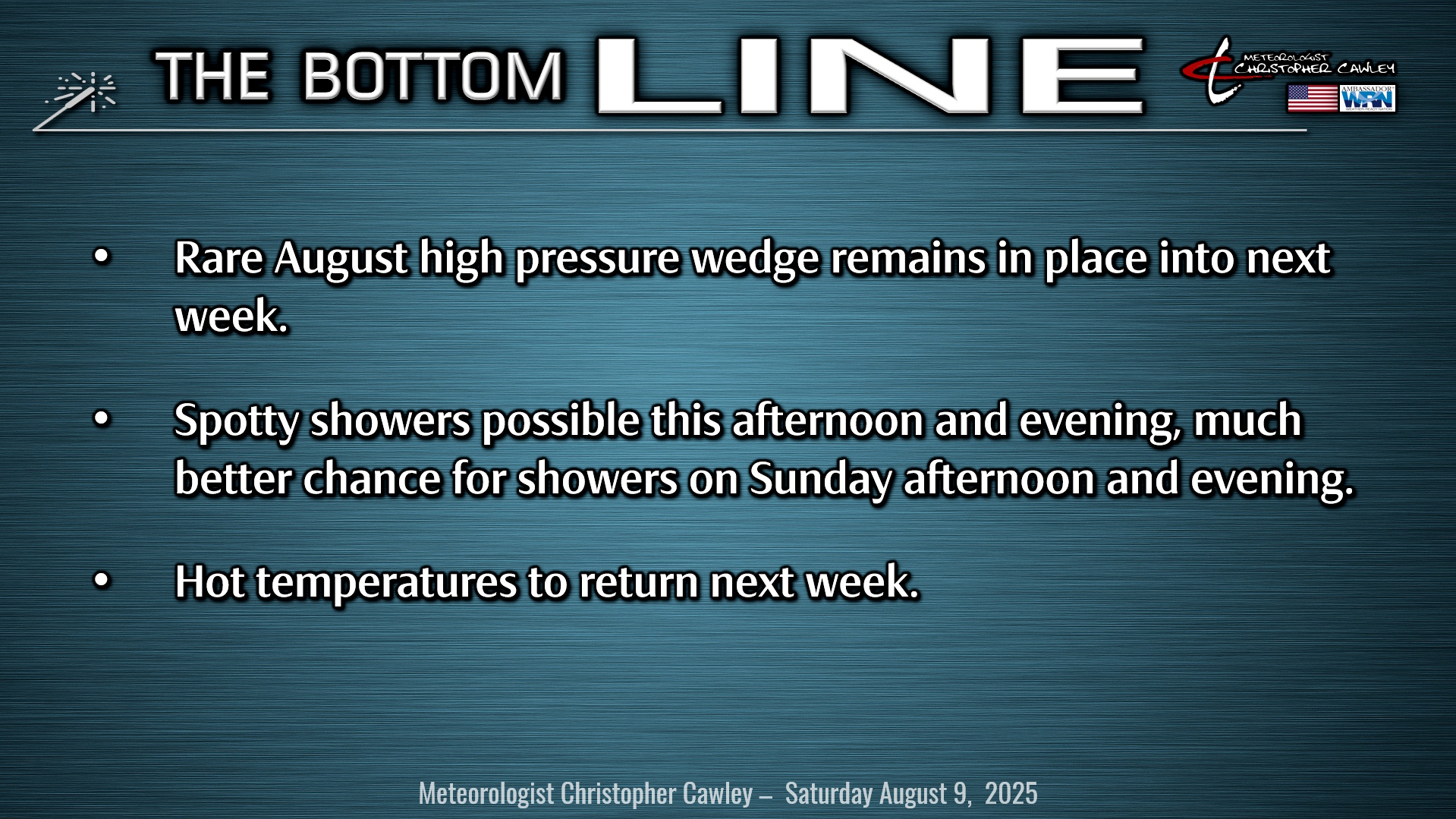
The persistent wedge of “cool” air damming that we have experienced for the past 5 days will continue for at least another 3 to 4 days. A light northeasterly wind flow at the surface is being overridden by deep southerly moisture. Yesterday was the first day in a while that the showers were largely absent. A few spotty showers did pop up but nothing on the magnitude that we experienced earlier in the week.
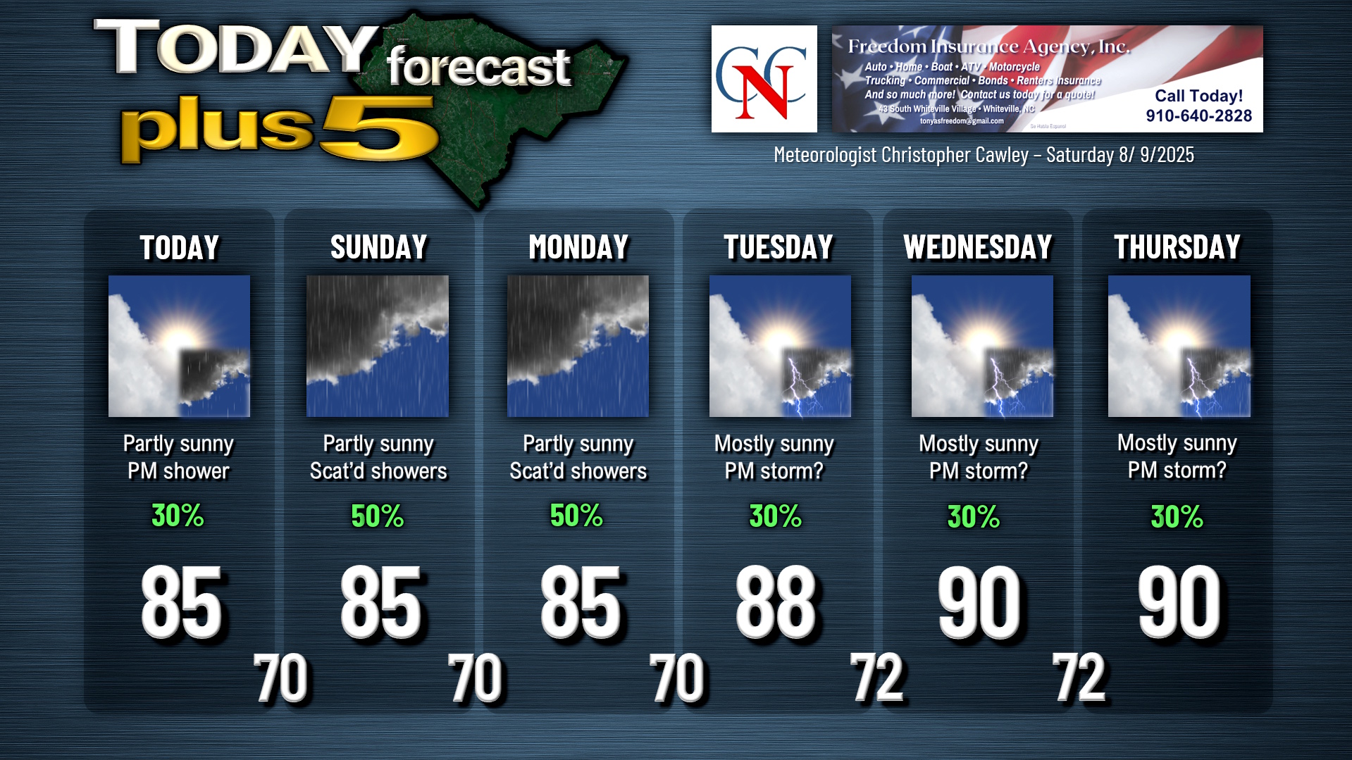
Today will be much of the same. Generally, lots of clouds, some breaks of sunshine, and a few spotty showers mainly between 2 PM and 8 PM. Coverage should be isolated to widely scattered, and while most of the showers should be light, a few heavier showers might develop. Basically, don’t lose the umbrella. You probably won’t need it, but there’s a chance that you might.
Sunday into Monday will feature a better chance for showers as a few shortwaves (disturbances, essentially) drop across the state, with more deep southerly moisture overrunning the wedged northeast surface flow. Coverage should still remain scattered, but I think we’ll see more activity. The model blend shows about 1 to 1.5 inches of rain across the county today through early Tuesday morning. Rain totals will be quite variable from location to location.
A couple of stronger fronts FINALLY breaks down the wedge pattern Tuesday into Wednesday. High pressure becomes established over the NC/TN border and goes just about nowhere through at least Friday. A weak coastal trough will likely be in place, and this could act as a trigger for afternoon thunder in the Tuesday-Thursday timeframe. Highs Tuesday should reach the upper 80s, and we’re finally at or above the 90-degree mark Wednesday and Thursday with only spotty thunderstorm chances.
TROPICS: A disorganized area of showers and thunderstorms a couple hundred miles off the coast of the Outer Banks will merge with a frontal boundary and move over cool waters. This now has a 0% chance for tropical development.
The area in the central Atlantic I’ve been watching carefully is in no hurry to develop into anything. The wave will continue to move northwest before curving northward, staying over the open ocean and also moving into cooler waters. The National Hurricane Center has lowered the potential for development down to 40% over 7 days.
Another wave moving off the African coast will continue a west-northwest journey over the open ocean. The NHC gives this a 20% chance of development over the next 7 days. This is the potential system that people are sharing model maps on social media … even questioning seasoned local meteorologists (friends of mine). The models people are looking at are depictions of a storm that hasn’t even developed and are wholly unreliable. The models people are looking at are nothing more than fuel for the hype train, and I don’t play that game. If it becomes something to worry about, you’ll hear about it here or on my socials. Until then….
Here is your Freedom Insurance Today-plus-Five Forecast:
–Meteorologist Christopher Cawley