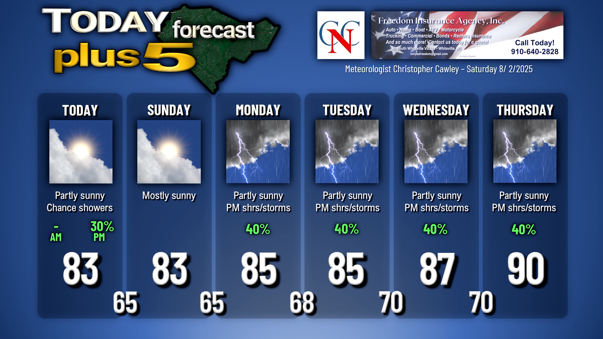
WeatherCCN Weather Update for Saturday August 2, 2025.
This weather update is sponsored by Freedom Insurance of Whiteville. No weather worries with Freedom Insurance. For home, car, boat, or whatever you need, Freedom can provide customized coverage to keep you and your family safe. Contact Freedom today at 910-640-2828!
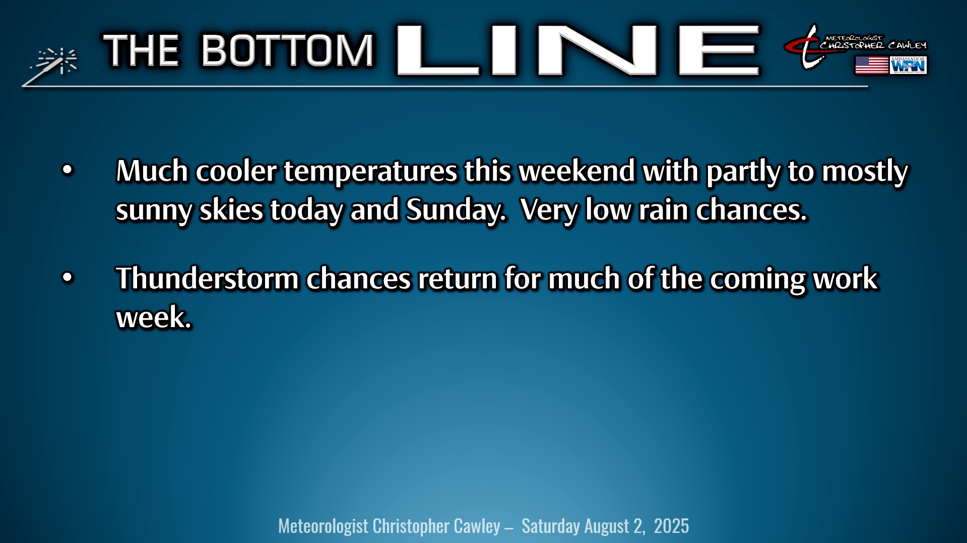
Here’s today’s Bottom Line
Very active weather yesterday evening across all of southeast NC will be much, much quieter today. A cold front moved across the region, right on schedule, and that was responsible for the significant coverage of thunderstorms yesterday evening. Numerous flood advisories were posted, as well as a prolonged flash flood warning for areas just to the north of us. Thunderstorms produced amazing lightning rates averaging 800-1300 flashes per hour!!
But that’s all gone for today in the wake of the cold front. High pressure will gain strength off to our north, extending from Iowa and Minnesota eastward off the coast. This will lead to a northeast breeze across North Carolina today. In the meantime, the front will stall well to our south, extending from the FL/GA line, curving up the coast. Two waves of low pressure will ride along this front.
What we have today is a battle between the high-pressure cells off to our north and those lows lifting along the front. If the front budges northward, even as little as 50 miles… that could mean the difference between partly to mostly sunny skies this afternoon and clouds/showers this afternoon. I am going with a 30% probability for showers this afternoon, so keep an umbrella handy just in case. We probably will be rain-free, but I can’t guarantee that.
The front really doesn’t go anywhere for Sunday, but with no further waves of low pressure, I think our rain chances on Sunday are less than 20%. If we get anything, it’ll likely be isolated at worst.
The bigger story is that the heat wave is ~~o-v-e-r~~!!! High temperatures today and Sunday will be in the lower to middle 80s (depending on cloud cover), and temps tonight/early tomorrow morning drop into the middle 60s! Open up the windows and get some fresh air in the house.
All in all I’m expecting a decent weekend… a mix of sunshine and clouds today and Sunday… a few scattered showers possible this afternoon… isolated showers Sunday afternoon.
The front refuses to go away into next week. Modeling shows two more waves of low pressure on the front on Monday, pushing it farther north closer to us. I’m not on board with a washout for Monday but I think we’ll see more in the way of shower-and-thunderstorm activity Monday afternoon and evening, probably similar to today with fairly widespread coverage. The front hangs up along the coast from Jacksonville, FL, northward to the Cape Fear Tuesday and Wednesday. This, combined with the sea-breeze and Piedmont trough, will lead to additional chances for shower and thunderstorm activity Tuesday through Thursday. Modeling shows the front trying to push back as a warm front Thursday-Friday but a lobe of high pressure over West Virginia might have something to say about that. I went with 90 on the graphic for Thursday but that’ll depend on whether or not the front actually makes it through here. If the high pressure wins, highs will remain in the upper 80s. Either way a decent chance for showers and thunderstorms continues through the end of the work week.
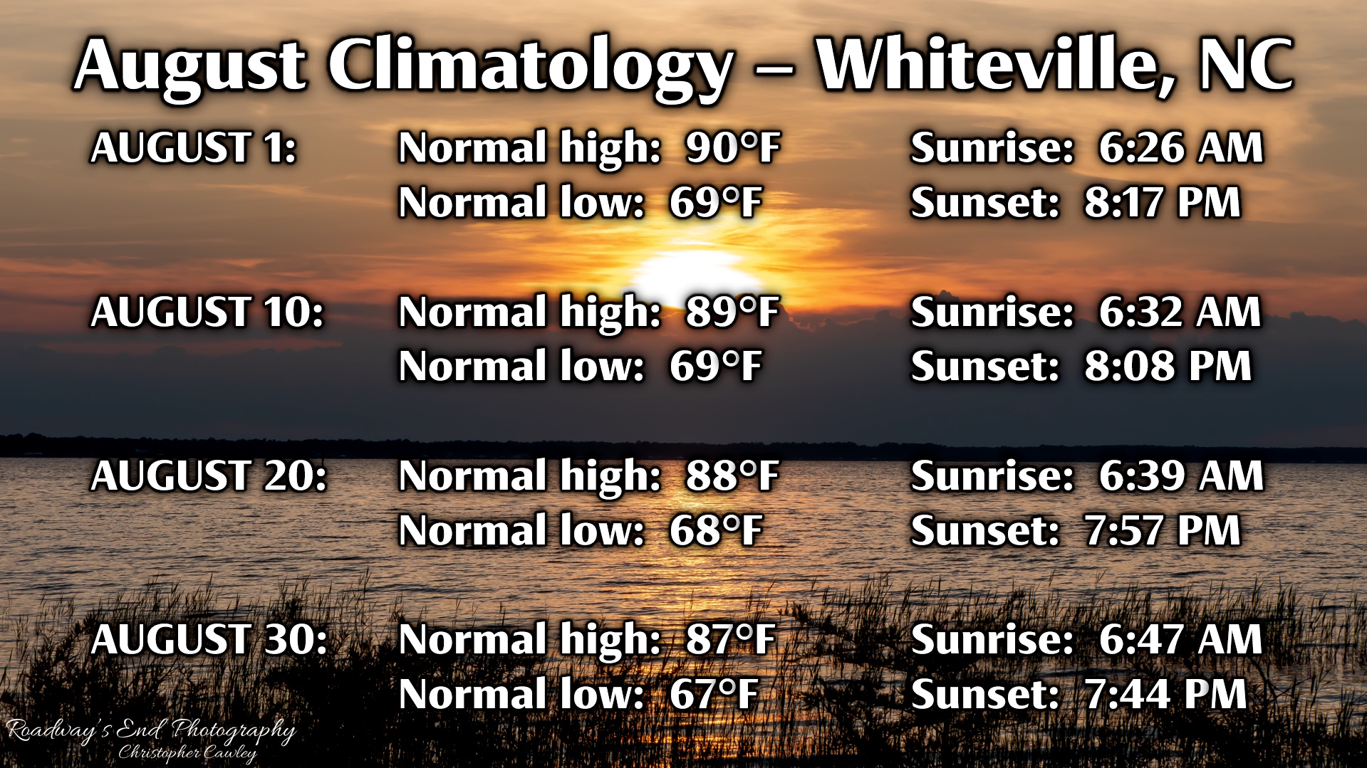
Below is a glimpse of August climatology for the Whiteville area. We’re on the “downside” of summer now, the final month of meteorological summer (meteorological fall begins on September 1st). Normal highs fall from 90 on the 1st to 87 on the 30th, while normal lows only drop 2 degrees — 69 to 67 over the course of the month. We’ll lose 21 minutes of morning light as sunrise on the 1st was at 6:26 AM… sunrise on the 30th is at 6:47 AM. We’ll lose even more minutes on the evening side… sunset on the 1st at 8:17 PM with sunset on the 30th at 7:44 PM.
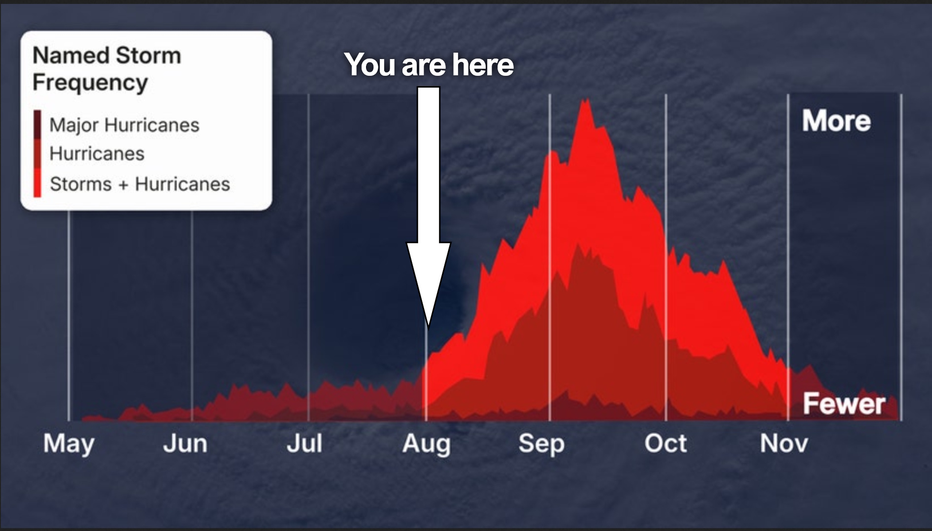
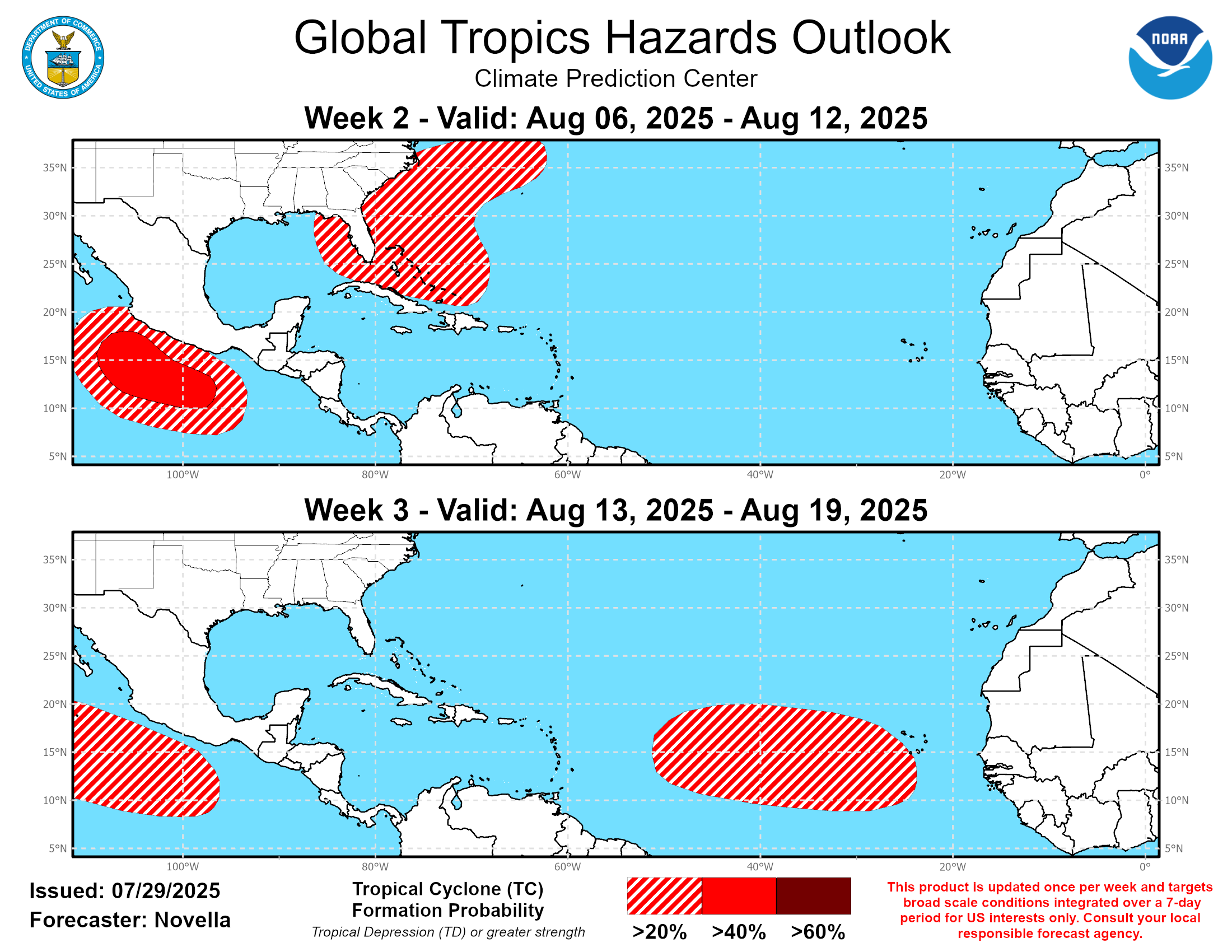
TROPICAL OUTLOOK: No concerning activity in the tropics at this time.
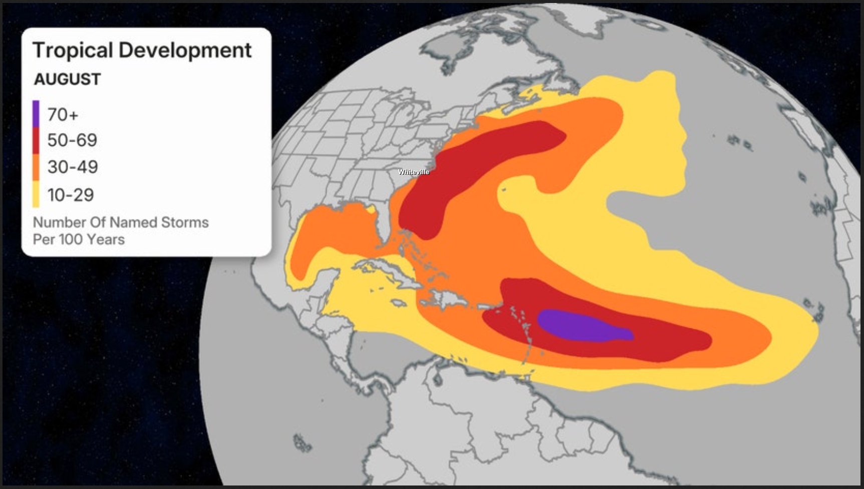
The attached images show where we are in the tropical season… the season activity normally ramps up quite a bit during the month of August. I also included an image of where storms tend to develop during the month of August. The third image is from the NWS and areas that they are going to be watching for potential development. Notice the hashed area just off our coast. That indicates a less-than-20% chance for “something” to develop.
Here is your Freedom Insurance Today-plus-Five Forecast:
–Meteorologist Christopher Cawley