
CCN Weather Update for Saturday November 8, 2025.
This weather update is sponsored by Freedom Insurance of Whiteville. Trust Freedom Insurance to give you clear blue skies when it comes to home, car, boat, or whatever insurance you need. Let Freedom provide customized coverage to keep you and your family safe. Contact Freedom today at 910-640-2828!
Here’s today’s Bottom Line
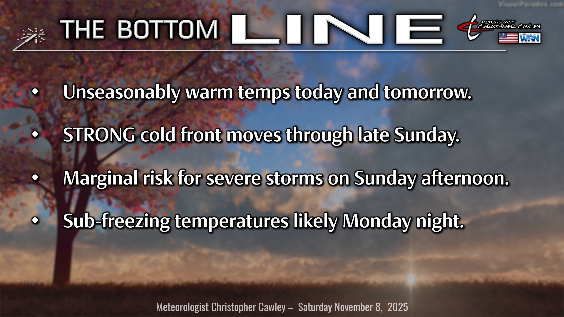
Unseasonably warm temps will turn unseasonably cold early in the work week, before averaging out to near normal.
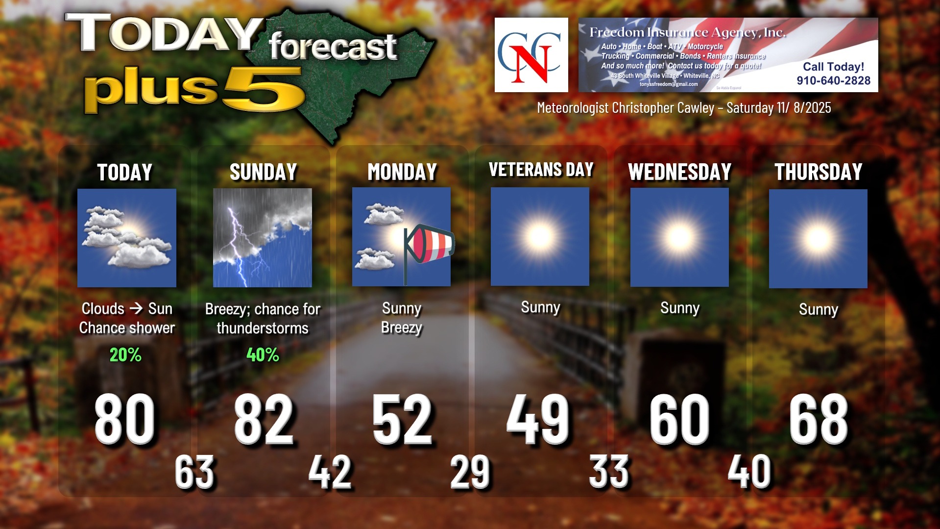
Today… expect some cloudiness this morning which will give way to sunshine by lunchtime into this afternoon. Southwesterly wind flow will allow our temps to soar to near (or possibly above) 80 degrees. There’s the chance, a low chance, but the chance for a few showers this afternoon given the warm and humid air mass. Perhaps even a rumble of thunder but that’s doubtful.
Tonight through Sunday… A “shortwave,” which is essentially an atmospheric disturbance, will move through the area late tonight into early Sunday. This may trigger a light rain shower or two but overall that shouldn’t amount to too much.
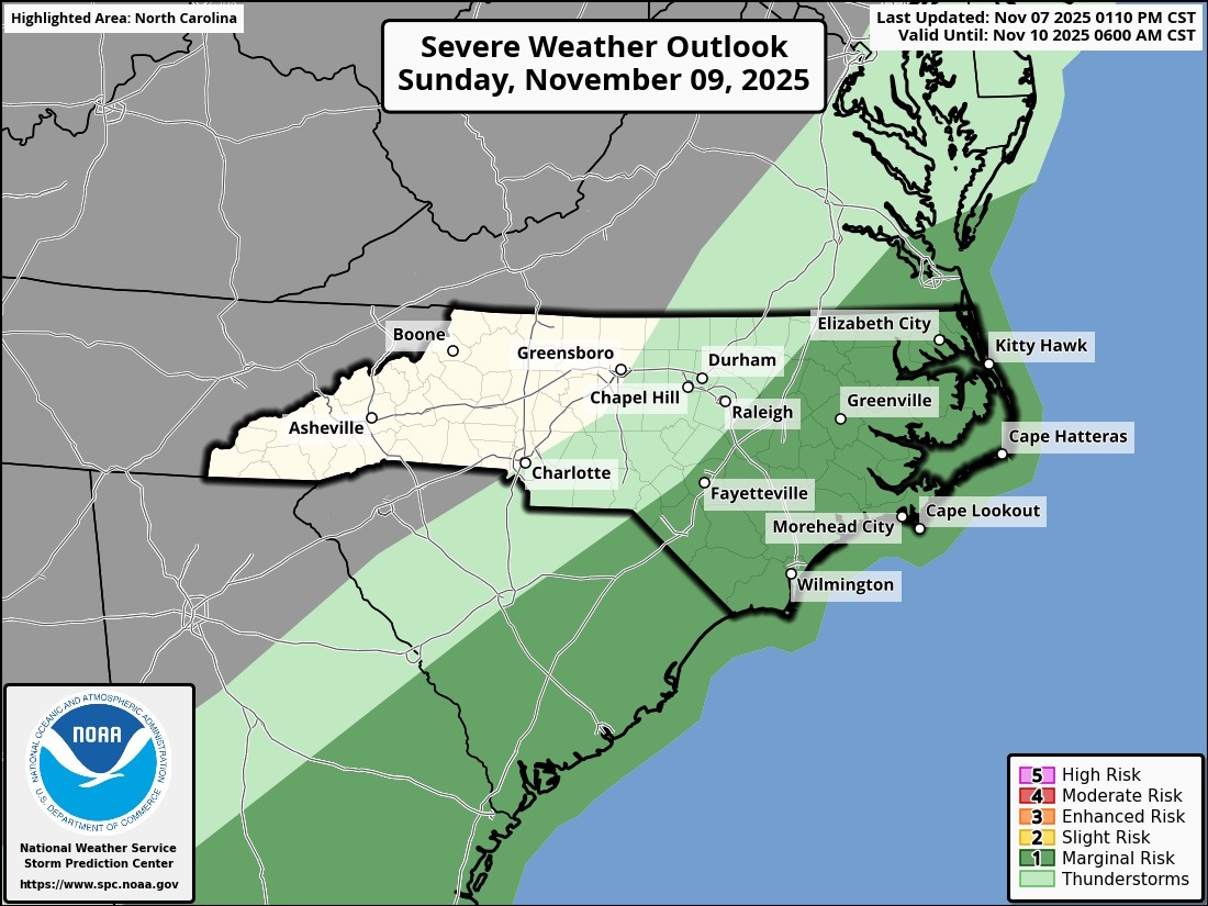
Then attention turns to a powerful cold front, one of the strongest fronts in quite a while, that will move through Sunday afternoon. Ahead of this front, a mix of sunshine and clouds can be expected with a robust southwesterly flow of warm, humid air. Temps should easily reach the lower 80s before the front arrives. The NWS Storm Prediction Center has posted a “marginal risk” (1 out of 5) for severe thunderstorms Sunday afternoon. Thunderstorm activity should be isolated to widely scattered… definitely not a widespread event.
Sunday Night through Monday… The front clears the coast by time we go to sleep Sunday night. West to northwest winds and relatively cloudy skies will keep our temps from really plummeting, but you can expect temps in the lower to middle 40s early Monday morning.
Monday will feature highs some 30 degrees colder than Sunday… struggling into the lower 50s with a mix of sunshine and clouds. Oh, and throw in northwest winds gusting 15-25 mph and you’ll definitely need a jacket.
FREEZE POTENTIAL MONDAY NIGHT: It is highly likely that temperatures dip below freezing late Monday night into early on Veterans Day. Skies will be crystal clear, but there *should* be enough northwest wind that true radiational cooling — the kind that occurs on clear, calm nights during the winter — should be avoided. That’s a good thing, because if we did get into a true radiational cooling trend, we’d have temps spiraling well down into the 20s. But as it stands right now, I expect temperatures 28-32 across the County, with the “warmest” temps being in the city areas. Plan on at least a couple of hours of below-freezing temps, especially in the outlying areas, early Tuesday morning.
As far as frost goes, that’s another thing that will be dependent on the wind. If winds go calm, then a widespread hard frost is likely to occur. As it stands right now, I think the frost will be scattered in nature.
Veterans Day and Beyond… Veterans Day will feature bright sunny skies… but temperatures might not get out of the 40s as that Canadian high pressure centers right overhead.
Clear skies and cold temps continue Tuesday night with a much more widespread frost likely as temps drop to between 32 and 35 across the county.
We’ll warm back up for the midweek period ahead of the next cold front. No rain in sight after Sunday.
TROPICS: Nothing doing. No concerns.
Here is your Freedom Insurance Today-plus-Five Forecast:
–Meteorologist Christopher Cawley