CCN Weather Update for Friday December 12, 2025.
This weather update is sponsored by Freedom Insurance of Whiteville. You can trust Freedom Insurance to give you clear blue skies when it comes to home, car, boat, or whatever insurance you need. Let Freedom provide customized coverage to keep you and your family safe. Contact Freedom today at 910-640-2828!
Here’s today’s Bottom Line
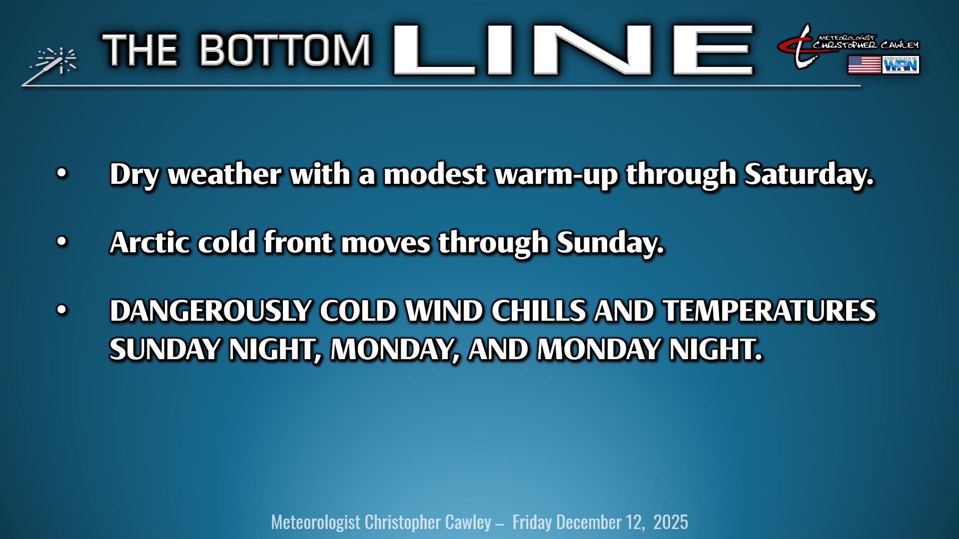
The big story will be that of a tremendous Arctic cold front that moves through at some point on Sunday. Significant deep Arctic freeze on tap Sunday night through Monday night.
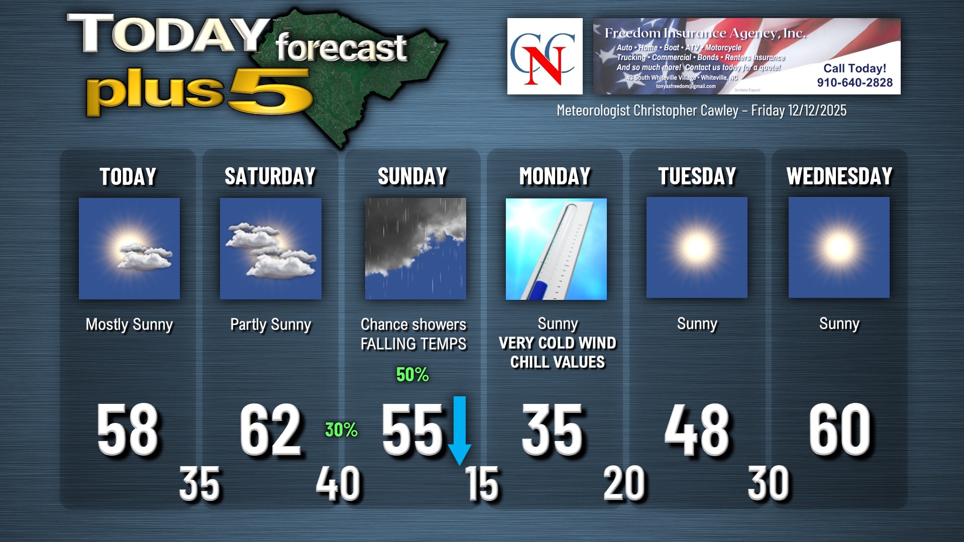
Before we get there though we’ll experience a modest warm-up today and especially on Saturday. A warm front will lift just north of the county today… and become stationary stretching across central North Carolina. High pressure over northern Florida will allow southerly air to push into the area, allowing our highs to rise to seasonable levels today, and into the lower 60s on Saturday. North of the front, though, temps will remain cold… so ultimate placement of the front will be the key. I’m confident in that it lifts north of the area allowing us some nice weather today and Saturday.
The front drops back south as a cold front late Saturday night, which may trigger a few light rain showers during the overnight hours. I don’t expect anything significant, though. The showers come to an end as a second front blasts through Sunday afternoon. The precipitation will be long gone before the heart of the cold air moves in … sorry … it’s not gonna snow.
The real action begins Sunday night. Intense cold air will absolutely cascade into the area… accompanied by 30-mph winds… by far the coldest air since mid-January. Temperatures fall Sunday afternoon and absolutely plummet after the sun goes down.
Monday morning will be BRUTAL. ALL of the available modeling points to wind chill values in the zero to 5-above range with actual air temps deep into the teens. The National Weather Service will likely issue a “cold weather advisory” for Monday morning.
Despite full sunshine through the day Monday, the air mass will remain brutally cold and our highs will not get out of the 30s. Wind chills remain in the high single digits to teens throughout the day, but the winds will go calm as the Arctic high pressure settles overhead Monday night. I put a “20” on the chart for Monday night, but I think that’ll need to be revised downward by a few degrees.
The upper air pattern rapidly returns to a zonal (west-to-east) flow allowing a big warm-up by the middle of the week, so this Arctic freeze will be relatively short-lived.
BE PREPARED FOR THIS DEEP FREEZE. Remember — people, pets, pipes, and plants. These will be the coldest temps in the area since the January snow event. Take the opportunity today and tomorrow to prepare your property for this significant Arctic freeze.
Here is your Freedom Insurance Today-plus-Five Forecast:
–Meteorologist Christopher Cawley