
CCN Weather Update for Saturday December 13, 2025.
This weather update is sponsored by Freedom Insurance of Whiteville. You can trust Freedom Insurance to give you clear blue skies when it comes to home, car, boat, or whatever insurance you need. Let Freedom provide customized coverage to keep you and your family safe. Contact Freedom today at 910-640-2828!
Here’s today’s Bottom Line
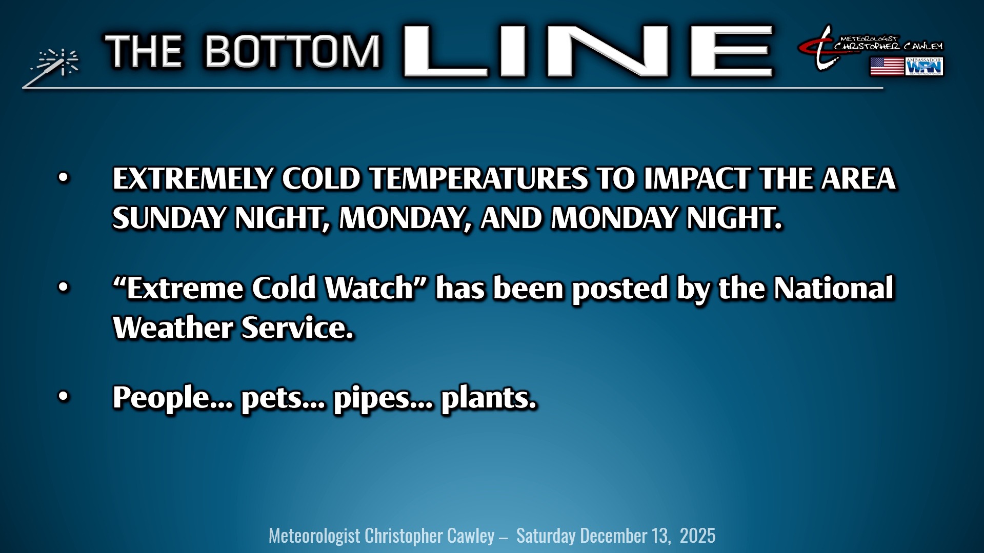
The big story remains the tremendous Arctic freeze that will occur Sunday evening, lasting through early Tuesday. It’s not “severe weather,” but the cold will be dangerous to those unprepared.
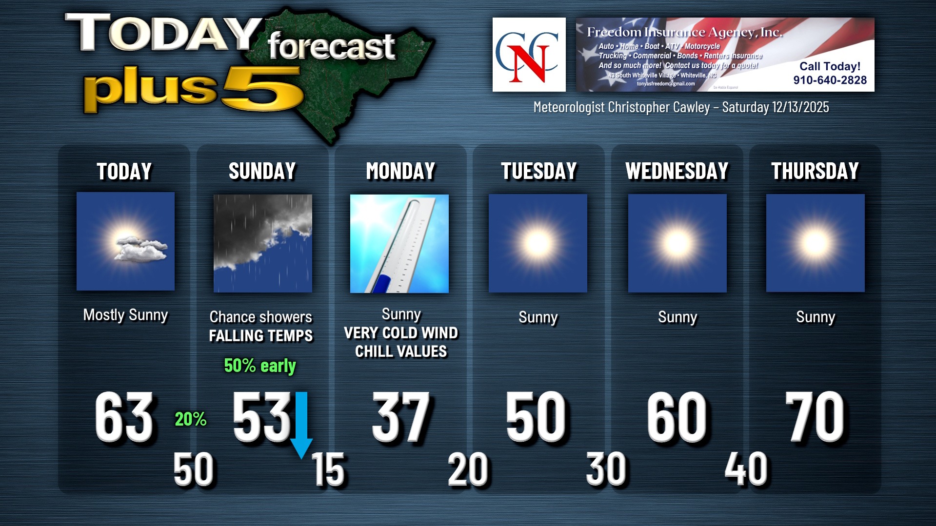
Today will be a really nice day with mild temps, perfect for taking the opportunity to prepare your property for the deep freeze. Highs should reach the lower 60s with lots of sunshine.
We’ll drop to the lower and middle 50s Saturday night… with temps holding steady through about mid-morning Sunday. An Arctic cold front will push through the area Sunday morning, with limited moisture. A few spotty showers are possible early Sunday. The front will be through here by Sunday afternoon, resulting in clearing skies and falling temperatures. By time the Whiteville parade starts, temps should be falling through the 30s on gusty northwest winds. Bundle up, dress in layers.
Temperatures continue to tumble Sunday night as gusty northwest winds continue. The National Weather Service has issued an “extreme cold watch” for the area for late Sunday night through Monday morning. Actual air temps should bottom out around 15 degrees, and when that is combined with winds around 20-25 mph, expect “feels like” temps (properly known as the wind chill) to be down around 5 above zero early Monday morning. This has already resulted in school delays, etc.
Precautions should be taken due to this dangerously cold air. Remember… people, pets, plants, and pipes.
People: Check on vulnerable family, friends, and neighbors (including elderly, children). If you must be outdoors, dress in layers and avoid prolonged exposure to the cold.
Pets: Bring pets indoors… if it’s too cold for you, it’s too cold for them, and they need shelter. Ensure they have enough adequate food and unfrozen water.
Pipes: Insulate exposed pipes in unheated areas such as crawlspaces, attics, and under sinks. Disconnect hoses and use insulated faucet covers. Let faucets drip slightly to prevent freezing. Open cabinet doors under sinks to allow warm air to circulate.
Plants: Move potted plants indoors or to a sheltered spot. Cover outdoor plants with blankets.
The Arctic high crests over the area during the day Monday. The winds will relax, but even with full sunshine, our highs will only reach the upper 30s. We’ll drop back down to the upper teens to around 20 on Monday night/early Tuesday.
The high then starts to push offshore on Tuesday and a zonal (west-to-east) wind flow becomes established. This eventually evolves into a southwesterly flow later in the week. The Arctic freeze will be a distant memory as daytime highs rise by about 10 degrees each day during the week… cresting near 70 by Thursday. Another cold front may cross the area by the end of the work week, but all indications are that it won’t be nearly the magnitude of what we’re seeing now.
Here is your Freedom Insurance Today-plus-Five Forecast:
–Meteorologist Christopher Cawley