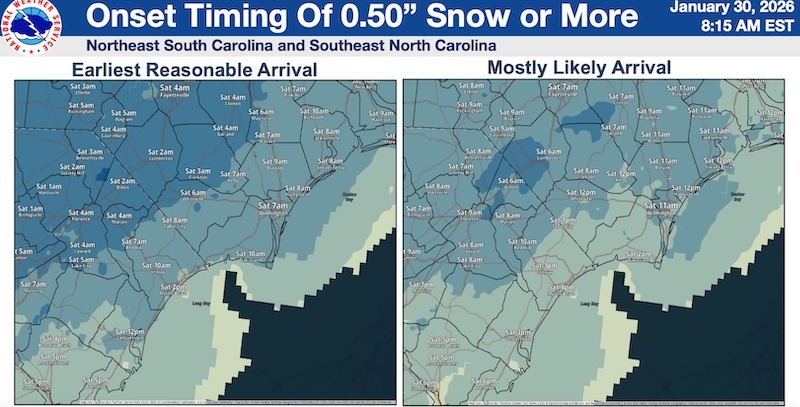

A major winter storm could bring four to ten inches of snow to Columbus County starting early tomorrow morning, with sub-zero windchills possible into Monday.
The system is expected to be the most potent winter storm to hit the area since 2018, when five to ten inches of snow, along with ice, crippled the county and froze Lake Waccamaw.
County officials were briefed this morning (Friday) and five more warming shelters will open tomorrow (see related story).
The county was upgraded from a Winter Storm Watch to a Warning today by the National Weather service.
“Forecast confidence is high that Columbus County will experience significant snowfall, extreme cold, strong winds, and hazardous travel conditions, with impacts likely extending into Monday,” County spokesman Howard Wallace said in a press release. “We must emphasize that this type of winter weather is uncommon for our area, and residents should take the threat seriously.”
Meteorologist Christopher Cawley said the NWS issued a Cold Weather Advisory for tonight through early Saturday evening, followed by an Extreme Cold Watch from Saturday evening through Monday morning. Single-digit wind chills expected Saturday night and Sunday night, and wind chills potentially dropping below zero. These conditions pose a serious risk of frostbite and hypothermia with prolonged exposure.
Powerful winds will also accompany the storm, with sustained winds 20-25 miles per hour and gusts up to 45 – winds more common with low level tropical systems and thunderstorms.
The dry, powdery snow combined with the wind late Saturday through Saturday night, will lead to blowing snow, severely reduced visibility, and particularly dangerous driving conditions. These winds may also contribute to scattered power outages across the county, according to the NWS.
“It’s not going to be a good time to be driving,” Cawley said in his live broadcast Thursday.
Freezing temperatures hit the county hard last weekend, leading to a few broken pipes, but the upcoming blast will be more severe. The City of Whiteville is advising residents to drip inside faucets, cover outside taps, and to make sure they have a supply of potable water in case of emergencies. If water service is interrupted due to a burst pipe, the city will not turn the water back on until repairs are made. Residents who use private wells should check or replace pumphouse lights and be sure pumps are protected from the weather.
“We were ready last weekend,” said City Emergency Services Director Hal Lowder, “and that gave us a chance to be sure everything is prepared for this storm. It’s going to be dangerously cold, and people need to be preparing today. There won’t be time to safely prepare tomorrow.”
Lowder also asked that people stay off the roads during and after the storm when at all possible.
“It’s going to be icy and dangerously cold,” he said. “We know everybody wants to be able to get out and enjoy the snow, but don’t be driving around sightseeing. Make sure your kids are bundled up. Hypothermia and frostbite are real things, and they can happen in these type of temperatures.”
County Animal Protective Service is urging petowners to bring their animals inside whenever possible. Straw, hay or chips should be provided for bedding, since blankets can freeze when they get wet. Outside animals should also have wind- and -moisture-proof shelters. APS also said that providing extra food can help animals stay warm, since like people they consume more calories in cold weather.
A number of area churches have cancelled services for Sunday. Western Prong Baptist will hold worship tonight at 6:30 p.m., with children’s church and nursery.
Columbus County Schools will be closed Monday, and students should be prepared for remote learning.
Southeastern Community College will be closed Saturday and Sunday. A decision will be announced later this weekend on Monday classes, but the college said students and staff should be prepared for remote learning.
Primary routes have been brined by the Department of Transportation, and trucks are working on some secondary roads. Bridges and overpasses in some areas will still be prone to accumulating ice and snow, making for dangerous travel conditions.
Crews with the N.C. Department of Transportation have transitioned from clearing roads from last weekend’s storm to treating roads to prepare for this second big storm. As of Friday morning, about 1,400 NCDOT employees had spread more than 2.6 million gallons of brine on interstates, highways, and other well-traveled roads statewide.
NCDOT workers will regroup and then be ready to start treating snow and ice once the storm arrives. NCDOT will also have chainsaw crews ready to respond to calls to cut and remove downed trees from roads and assist utilities when trees become entangled in power lines. The agency will work in 12-hour shifts until all state-maintained roads are cleared.
“All North Carolinians should be finalizing plans now and should be prepared to stay home and off the roadways starting tonight through early next week,” said state Director of Emergency Management Will Ray. “Please check on your family, friends, and neighbors, as well as those in your community who may need additional support.”
The heavy snowfall expected for much of the Tar Heel State on Friday and Saturday will likely make travel dangerous.
“We fully expect road conditions to deteriorate very quickly once the storm arrives, and conditions could remain treacherous well into next week,” said State Transportation Secretary Daniel Johnson. “We’re going to be working hard throughout the storm, but we need people to enjoy the snow from home so our crews can clear the roads.”
At 6 a.m. Friday, the NCDOT and State Highway Patrol activated immediate towing statewide. North Carolina law allows officials to immediately tow abandoned or disabled vehicles from roads and shoulders to protect other drivers and enable emergency responders and transportation crews to do their work. The immediate towing efforts are focused on highways and other primary routes. The immediate tow measure will remain in place until the SHP and NCDOT determine it can be safely lifted.
Columbuscountynews.com has a list of closures and delays that will be updated as new announcements come in. Send your schedule changes for churches, vici groups, businesses and others to CCN.CFaircloth@gmail.com or CCN.JWeaver@gmail.com.
Copyright 2026 Columbuscountynews.com. All Rights Reserved.