
CCN Weather Update for Friday January 23, 2026.
This weather update is sponsored by Freedom Insurance of Whiteville. You can trust Freedom Insurance to give you clear blue skies when it comes to home, car, boat, or whatever insurance you need. Let Freedom provide customized coverage to keep you and your family safe. Contact Freedom today at 910-640-2828!
Here’s today’s Bottom Line:
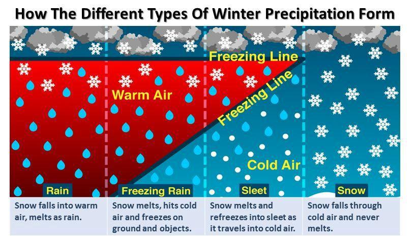
Let’s start off by talking about WINTER WEATHER PRECIPITATION TYPES
Sleet: Precipitation starts off as a snowflake at the cloud level. The snowflake falls into a layer of air that is above 32 degrees, causing it to melt into a raindrop. This warmer layer of the cake is rather thin, and the raindrop falls into a very thick layer of sub-32-degree air that extends to the surface. Since this layer is thick, the raindrop freezes into an ice pellet. That is sleet.
Freezing Rain: Precipitation starts off as a snowflake at the cloud level. the snowflake falls into a thick layer of air that is above 32 degrees, causing it to melt into a raindrop. This warmer layer of cake is large… but sub-freezing air does exist at the surface (up to about a couple hundred feet). The raindrop doesn’t have “time” to refreeze, so it remains liquid until it strikes the Earth’s surface, forming a glaze.
So yes, it will feel like it’s raining… because it is… but if the surface temperature is below 32 degrees, that rain freezes on contact. Hence, freezing rain.
Ok, that’s out of the way, let’s talk about the storm.
======
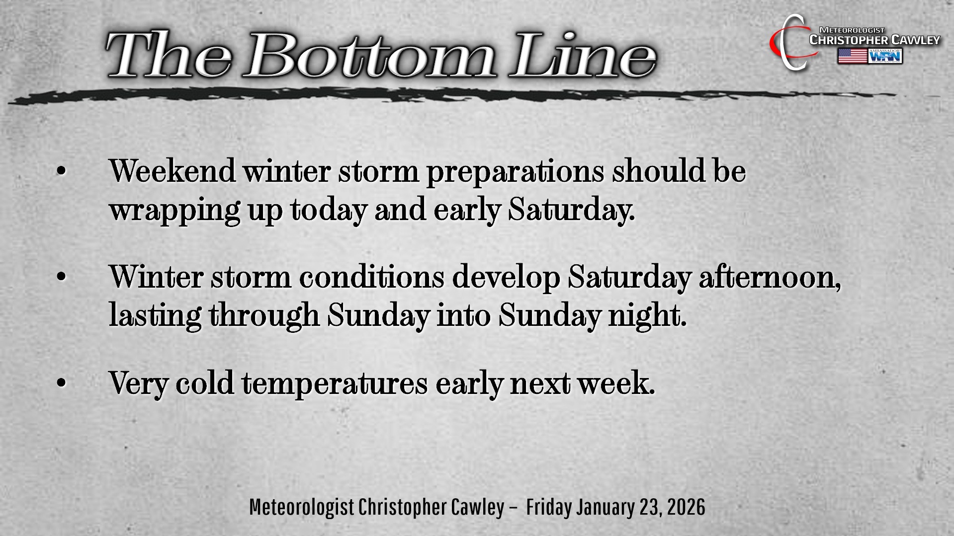
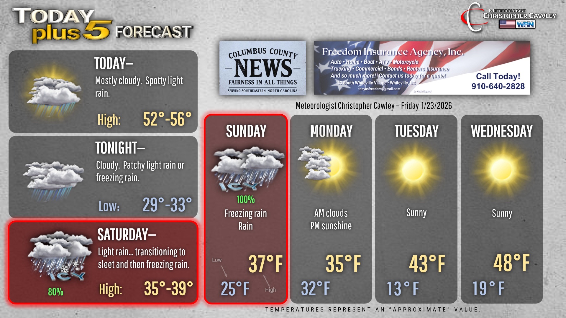
Your winter storm preparations should be coming to a completion today.
Today’s weather will feature a bit of a shortwave zipping overhead with some light rain. We’ll be cooler than yesterday, highs will be in the 50s (which is actually where we should be this time of year).
Lots of clouds for tonight with some patchy light rain or even some freezing rain after midnight, but not quite enough to cause any immediate travel concerns.
Now… the winter storm.
SATURDAY: We’ll start off with a little bit of sunshine, but expect some light rain or sleet to develop around lunchtime. This will transition to light freezing rain by suppertime, especially over the western half of the county.
SATURDAY NIGHT: Periods of mainly light freezing rain. Surface temperatures will be in the 20s, but temperatures at the middle and upper levels of the atmosphere will be in the mid 30s to around 40… which is the reason for experiencing freezing rain. This warmer air is of Gulf origination, and rises “up and over” the Arctic surface air.
SUNDAY: Freezing rain will eventually transition to “plain rain” as the temperature at all levels of the atmosphere rises above freezing.
SUNDAY NIGHT: Periods of rain will continue into Sunday evening and Sunday night before ending, probably as another brief period of freezing rain as temperatures drop to around 30 degrees.
STORM TOTAL ICE FORECAST AS OF THIS WRITING – Between 0.10″ and 0.25″ for Columbus County, lesser amounts to the south/east portions of the county, higher amounts from Fair Bluff through Evergreen and Boardman.
The ice accretion forecast may change depending on the placement of the low pressure center. A 50- to 100-mile shift in storm track can mean much higher ice totals … or no ice whatsoever.
It will become a situation known as “nowcasting” vs “forecasting” as the system begins to impact the area, as there will be unknowns right up until the kickoff.
HAZARDOUS TRAVEL CONDITIONS are likely Saturday night, through the day Sunday, into Sunday night, and possibly into Monday.
The predominant precipitation type through this event will be that of freezing rain. I believe the warm layer of the atmospheric cake will be thick enough that sleet will not occur… and certainly this is not a snow situation.
We’ll see increasing sunshine on Monday but bitterly cold temperatures will occur Monday night. Anything “wet” / melted on Monday will re-freeze Monday night, so expect icy road conditions again Monday night into early Tuesday. Bitterly cold wind chill values in the single digits are LIKELY Monday night. Bus stop temperatures early Tuesday (if there’s school), are likely to be between 10 and 15 degrees with a wind chill between 5 and 10 degrees above zero.
Now…
There’s some rumor going around… and people sharing more model maps… regarding a possible storm NEXT weekend. Those model maps have already changed and now, as of this writing, aren’t showing much of anything that gets my attention. I think we need to learn a lesson from this storm and how the modeling has changed and evolved. ANYTHING beyond 5 days is … junk. And that little snowflake icon on your weather app will probably change to a sun icon or a lightning bolt to a raindrop and half a dozen other things.
Let’s get through this storm before we worry about what may or may not come 10 days from now.
Here’s your Freedom Insurance Today-plus-Five Forecast!
–Meteorologist Christopher Cawley