
CCN Weather Update for Thursday January 29, 2026.
This weather update is sponsored by Freedom Insurance of Whiteville. You can trust Freedom Insurance to give you clear blue skies when it comes to home, car, boat, or whatever insurance you need. Let Freedom provide customized coverage to keep you and your family safe. Contact Freedom today at 910-640-2828!
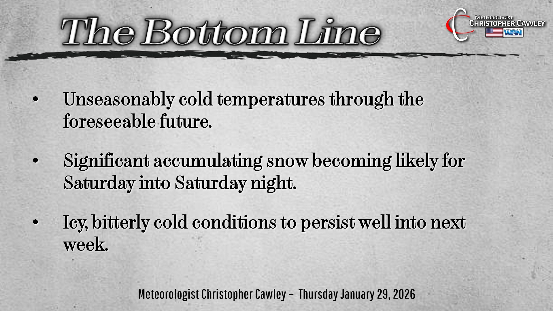
Here’s today’s Bottom Line:
Well it’s becoming more and more likely that we’re going to have a third consecutive crazy weather weekend.
And here in southeast North Carolina, nothing comes simple. Nothing is black and white. Because that would be too easy.
So let’s talk snowstorm. The “TL/DR” version is this. Low pressure on the southern jet stream will move up the coast. Another low, well, really what’s known as an “H5 trough,” will dive southward from Michigan to northern GA/SC southwest NC… and then is likely to “phase” (or combine) with the coastal low, creating what is known as a bomb cyclone.
No that’s not a gimmick, that’s a thing — bombogenesis. This is when low pressure explosively deepens off the coast, with a dramatic barometric pressure drop in a very short period of time.
WHAT IS CERTAIN —
1. It’s going to be COLD. During and after the storm. Bitterly cold wind chills down around ZERO likely Sunday night and Monday night. So no matter what we get from the storm, DANGEROUS COLD TEMPERATURES will prevail well into next week.
WHAT IS “FAIRLY CERTAIN” —
1. Low pressure scooting along the northern Gulf coast, transitioning across Florida, and then pushing northeast along the coast.
2. The upper-level low (trough) that will dive southward over the Appalachians.
3. We will get SOME accumulating snow here.
WHAT IS “NOT SO CERTAIN”
1. The location of the coastal low.
2. The timing of the combining of the trough with the coastal low.
3. Snowfall amounts.
4. Potential for some rain to mix in Saturday afternoon.
SUMMARY:
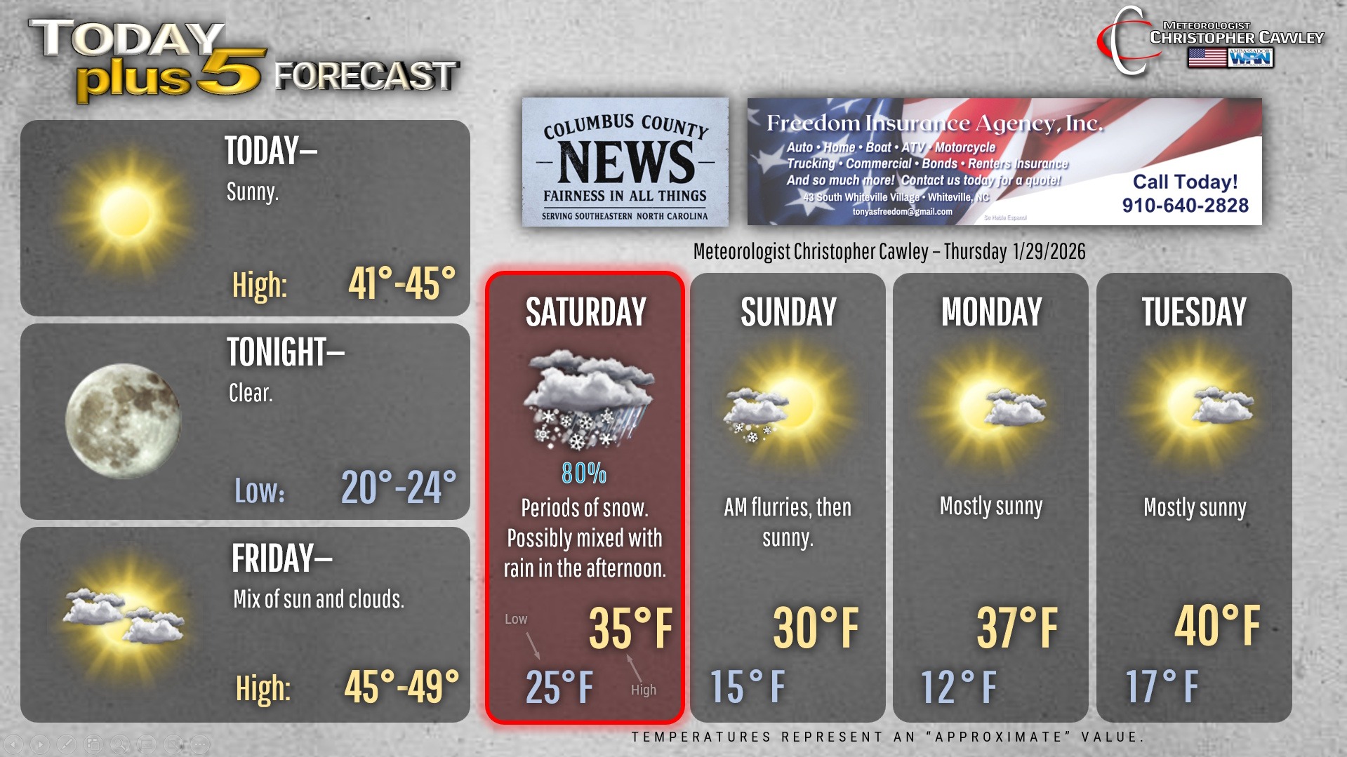
I expect periods of light snow to develop during the overnight hours Friday night/early Saturday. Accumulations should be light, but with a cold ground surface, there will be some icy spots on bridges on Saturday morning.
Saturday: Periods of snow becoming more widespread and steady as we go through the day. For areas east of US-701 from Clarkton to Tabor City, there is some indication that rain might mix in with the snow.
I don’t think we’ll see a complete changeover, but I can’t rule it out either.
Any rain we get will cut down on snow totals.
Travel conditions will become steadily worse throughout the day.
Saturday night: Any rain/snow mix quickly changes to all snow. Snow will continue, possibly heavy at times during the evening, and then taper off during the overnight.
Winds start to become gusty, creating some blowing and drifting snow. That’s RARE in this area. Wind chills early Sunday morning drop to the single digits.
Sunday: A few morning flurries will give way to bright sunshine. Despite that, temperatures are likely to stay below freezing. Now there will be some melting simply because of the direct solar radiation… and anything that melts will re-freeze Sunday night as we drop deep into the teens.
Travel conditions will be extremely difficult Saturday night and only improving slightly on Sunday. Roads will be icy and dangerous, especially secondary roads.
SNOWFALL AMOUNTS: Here’s what you want to know. I’m going VERY CONSERVATIVE with my snow forecast. Generally north of 74/76, I expect between 3 and 6 inches of snow to fall. South of that, I’m going with 2 to 4 inches.
NWS “Winter Storm Warning” criteria is 2 inches.
I’m going on the low end of model guidance with regard to snow totals. There are some models that suggest this will be a repeat of Christmas 1989. I’m not ready to accept that, but yes, it COULD happen.
There’s also the very slim chance we get very minimal snowfall amounts.
Truthfully, the exact amounts aren’t going to be known until the storm actually begin. We move into a “nowcasting” phase.
It’s possible that Chadbourn gets 6-7 inches, Whiteville 3-6, LkW 3-6, Delco 2-3, Tabor City 2-3, Nakina 1-3. Lumberton may see upwards of a foot, while Shallotte and Southport barely get anything.
So I think a reasonable “best guess” at this point is 3-6 north of 74/76, 2-4 south. Subject to change!
I will be doing another Facebook Live event tonight at 7:15 on the Columbus County News Facebook page, where I will go over the very latest information, the NWS Hazard Briefing, and what we can realistically expect.
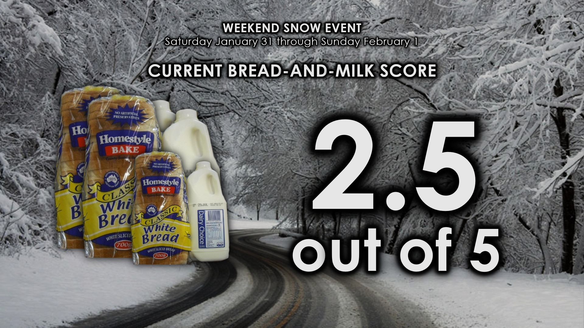
The current unofficial Bread-and-Milk rating, as of right now, is 2.5 out of 5.
Here’s your Freedom Insurance Today-plus-Five Forecast!
–Meteorologist Christopher Cawley