CCN Weather Update for Tuesday January 20, 2026.
This weather update is sponsored by Freedom Insurance of Whiteville. You can trust Freedom Insurance to give you clear blue skies when it comes to home, car, boat, or whatever insurance you need. Let Freedom provide customized coverage to keep you and your family safe. Contact Freedom today at 910-640-2828!
Here’s today’s Bottom Line:
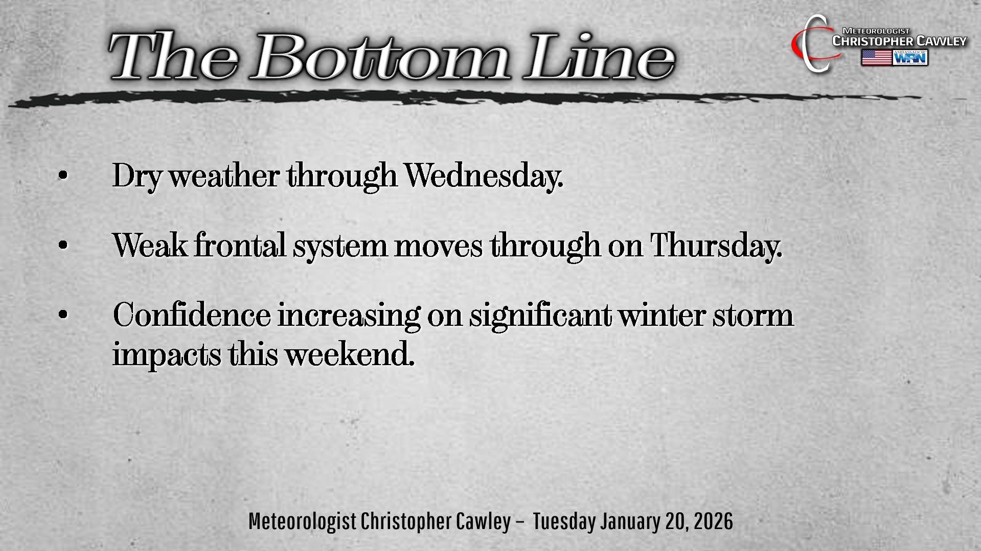
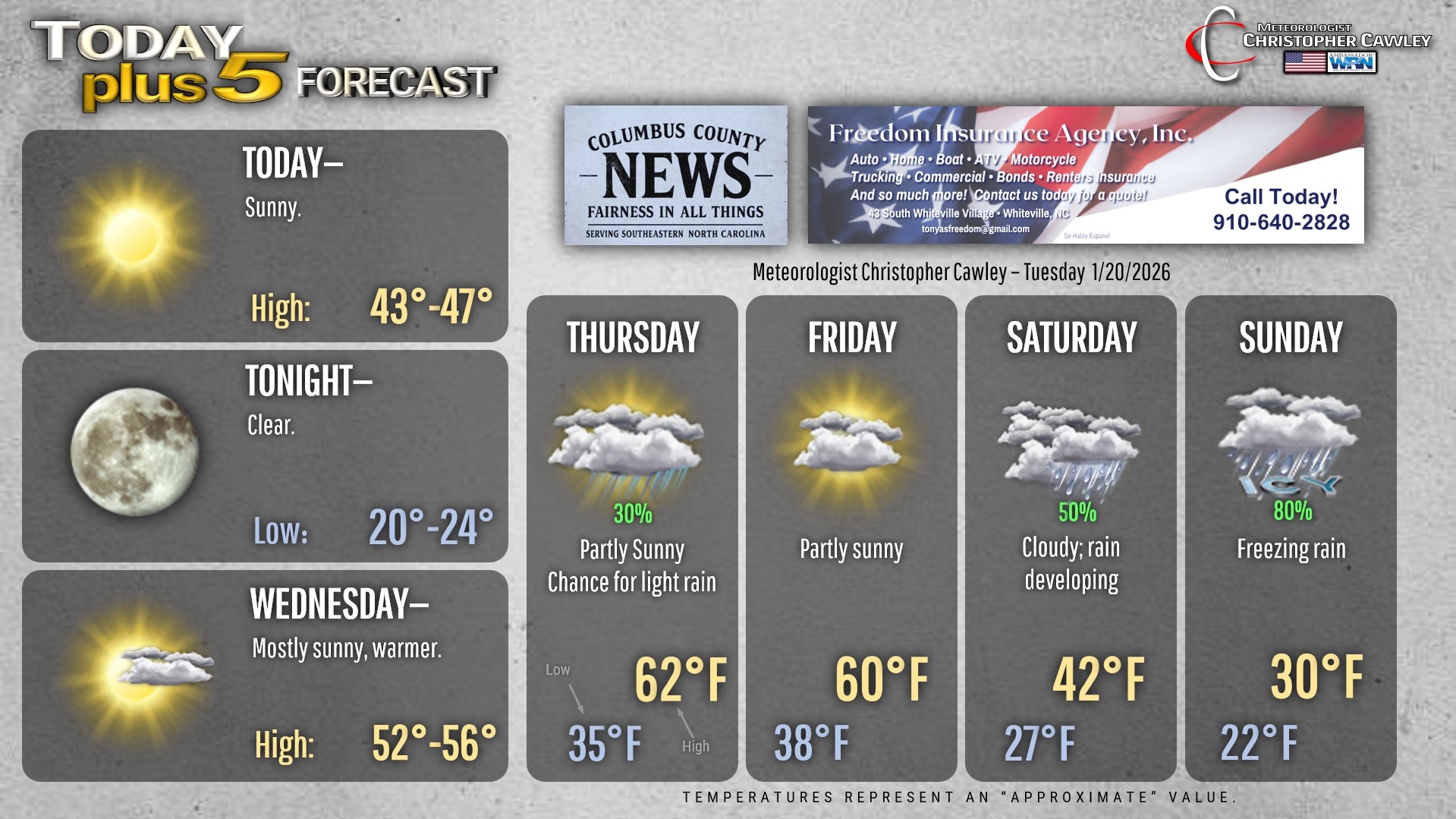
Dry weather will prevail today and Wednesday… warmer temperatures for Wednesday.
A weak cold front will cross the area Thursday with a chance for showers and mild temperatures… with more mild temps likely on Friday before things become very interesting over the weekend.
WEEKEND WINTER STORM
WHAT IS KNOWN:
— There is high confidence in strong high pressure bringing cold temperatures into the area.
— Moderate to high confidence in a large-scale winter storm impacting the area mid-south and mid-Atlantic states.
— Moderate confidence in impactful weather this weekend due to wintry precipitation.
WHAT IS NOT KNOWN:
— Exact timing of the storm, including duration of any wintry precipitation.
— Dominant precipitation type (snow vs freezing rain vs sleet), and whether it will alternate between types.
— Placement of the wintry precipitation and scope of potential impacts.
WHAT SHOULD YOU DO?
— Continue to follow the Freedom Insurance Daily Weather Update, as well as the National Weather Service in Wilmington for further information. Please check timestamps with all posts you see.
— Review your severe winter weather preparedness plan.
— Be prepared for an extended period of bitterly cold temperatures during and after the storm.
— Be prepared for prolonged power outages, tree damage, and difficult travel.
OVERVIEW: A large area of high pressure to the north will bring very cold air down into the Carolinas over the weekend, particularly Saturday night and Sunday. At the same time, moisture will be lifting northward from the Gulf with an area of low pressure… or possibly a couple of areas of low pressure… skirting across the southeast US, pushing off the South Carolina coast sometime Sunday.
North of the low pressure center, temperatures will be cold enough through the entire atmosphere (cloud layer to ground) to support snow, and lots of it.
However, along the low track the depth of the cold air will be such that a significant “section” of the middle and upper layers of the atmosphere will be above 32 degrees, supporting liquid precipitation. The rain falls into a shallow area of frigid air near the surface, and the rain freezes instantly on contact. I fear that is going to be our scenario, based on the current modeling.
A glimmer of hope is that the Canadian modeling shows the low moving essentially across northern SC and central NC, which would result in snow/ice transitioning to rain on Sunday, leaving us with lesser ice accumulations.
The worst-case is the latest Euro which shows three-quarters to at least ONE INCH of ice accumulation. That will result in a crippling impact with prolonged power outages and significant infrastructure damage.
There’s still a lot of time to watch this. As we move into the Wednesday/Thursday timeframe, we’ll have much more knowledge including a better handle on precip type and maybe even preliminary amounts.
Until then, we’re in “watchful waiting.” Begin your winter weather preparedness plan for this weekend. Also, please be kind and considerate to others when rushing out to Walmart or Food Lion. There’s no need to buy ALL of the bread and milk, beer, TP, etc. Save something on the shelf for someone else.
Here’s your Freedom Insurance Today-plus-Five Forecast!
–Meteorologist Christopher Cawley