CCN Weather Update for Tuesday January 27, 2026.
This weather update is sponsored by Freedom Insurance of Whiteville. You can trust Freedom Insurance to give you clear blue skies when it comes to home, car, boat, or whatever insurance you need. Let Freedom provide customized coverage to keep you and your family safe. Contact Freedom today at 910-640-2828!
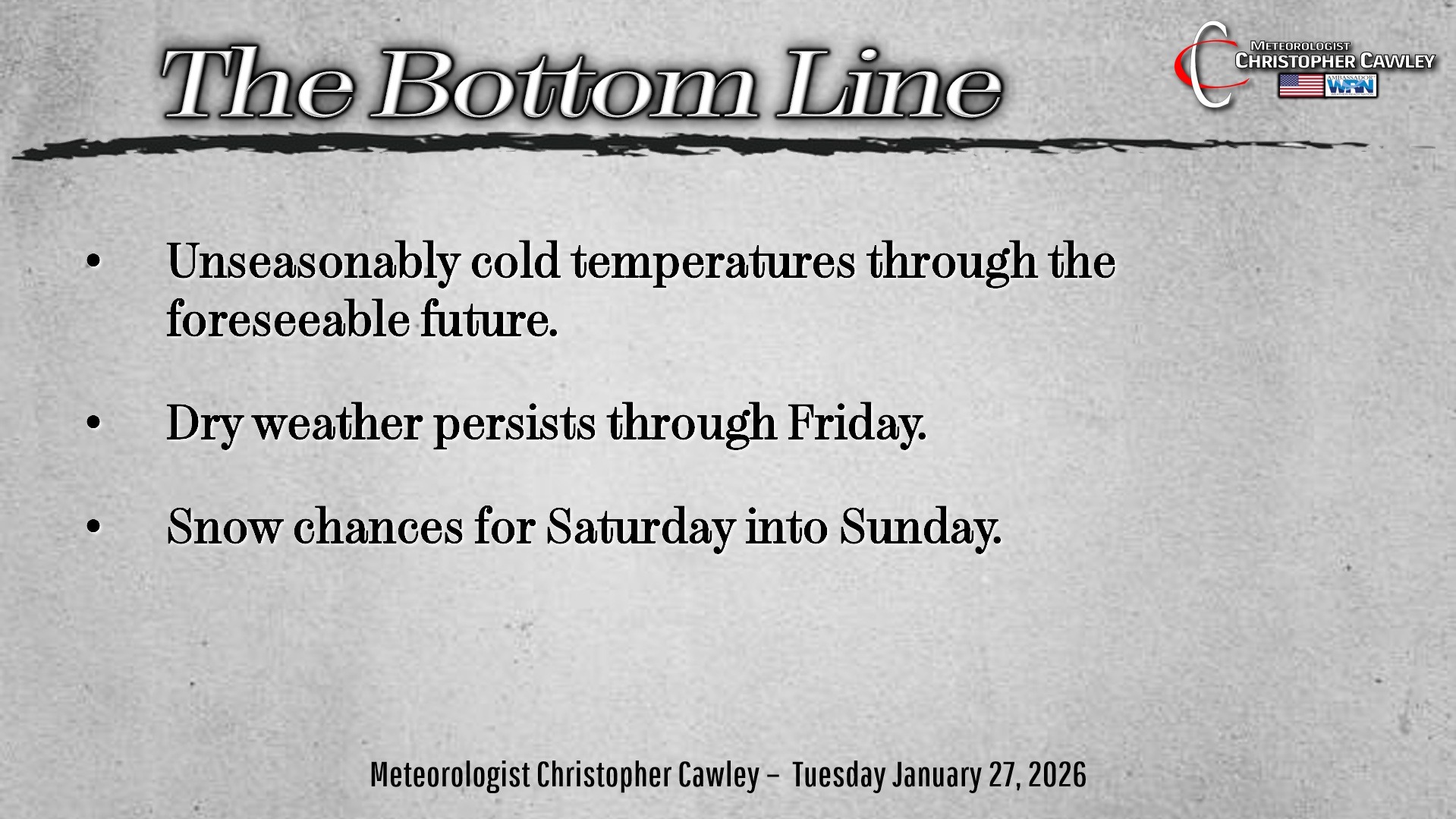
Here’s today’s Bottom Line:
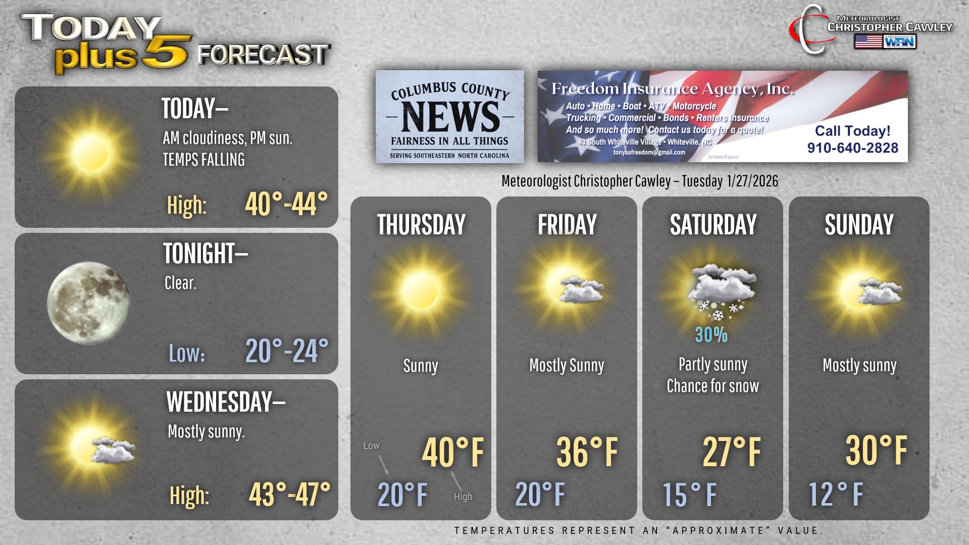
Just as a “FYI” – today’s normal high is 55 degrees, the normal low is 32. File that under “just saying.”
Unseasonably cold air will be locked in place through the foreseeable future as an Arctic high pressure cell continues to dominate. Highs today will be in the lower 40s with lows around 20. Much of the same for Wednesday… slightly milder afternoon highs.
Then a dry Arctic cold front drops down from the north Wednesday night, knocking our highs down to around 40 on Thursday.
STRONG Arctic high continues to slip southward over the north-central United States, extending its influence through the Mississippi Valley on Friday. This drives even colder air into the area… highs on Friday probably won’t reach the 40-degree mark.
At the same time, low pressure will be organizing along the northern Gulf coast, on the southern jet stream.
Another weekend storm possibility? Yep.
At minimum, this will bring even more cold air into our area. The GFS and European deterministic models AND their respective ensembles are solidly BELOW FREEZING for the upcoming weekend. And, more importantly, well-below-freezing for the entire atmospheric column (from the sky to the ground). The modeling indeed shows very cold air.
So the presence of cold air won’t be a concern for what COULD BE a winter storm this coming weekend.
Now let’s talk about wintry precipitation possibilities. As I mentioned, a surface low will form on the southern jet. Both the Euro and GFS show this transitioning to an explosive low pressure center along a frontal boundary somewhere offshore.
The strength and location of this low will play a huge role in how this weekend plays out. Generally, the global models are in agreement on the strength of the low as it matures, but they disagree like politicians when it comes to the location, timing, and speed of the low.
Let’s assume a storm does form. Based on historical track paths favoring snow in this area (including last year’s picture-perfect setup), as of right now the Euro has the most ideal track … but it develops the low too late to pull in the moisture that we would need for snow. So the result would be perhaps some light snow showers but bitterly cold air. Now, these models update every 6-12 hours. As we learned with the last system, what is shown today could go *poof* by this time tomorrow.
The GFS shows the low MUCH closer to the coast. Normally this would bring in warmer air resulting in a sloppy mixed mess, but the cold air that will be in place from the Arctic high will be profound… so dramatically cold that the “warming” still results in below-freezing temps.
Ensemble models are all over the place right now, which is understandable this far out.
Confidence for this weekend’s system is EXTREMELY LOW with regards to …
a) what wintry precip, if any, we get,
b) the timing of the storm,
c) if a storm even forms on the coast in the first place.
There’s lots of time to figure this out in the next few days. There’s really no point in having specific discussions about who sees what, and when.
If there’s anything I’m comfortable in saying, the setup favors snow more than anything else. I don’t see another wedge pattern, like we saw this past weekend. If any warming does occur, it will be at the surface … but probably not enough to kick us above freezing.
One final limiting factor this weekend will be the bone-dry air from the Arctic high. Air that is this frigid cannot hold much moisture, so it will be quite dry.
Given all the uncertainties, I’m only putting a 30% risk for snow on the graphic below.
“Stay tuned.”
Here’s your Freedom Insurance Today-plus-Five Forecast!
–Meteorologist Christopher Cawley