CCN Weather Update for Wednesday January 14, 2026.
This weather update is sponsored by Freedom Insurance of Whiteville. You can trust Freedom Insurance to give you clear blue skies when it comes to home, car, boat, or whatever insurance you need. Let Freedom provide customized coverage to keep you and your family safe. Contact Freedom today at 910-640-2828!
Here’s today’s Bottom Line:

Well if you like really cold January weather, I’ve got some good news to report.
If you’re looking for a winter wonderland of snow, I’ve got some not-so-good news to report.
Today will feature more clouds than sunshine and we have the chance for some light rain this afternoon. This will be ahead of a fairly strong cold front that will move through later on this evening. Our highs will be seasonable, generally in the mid to upper 50s.
As mentioned, the front moves through this evening with another round of light rain (maybe). There’s just a lot of dry air in place and I don’t think we’re going to see a lot in terms of precipitation.
Whatever moisture that does exist will exit stage-right before the depth of the colder air moves in. This means… no snow this time.
Thursday is going to be brutal. We’ll see increasing sunshine, but gusty west/northwest winds. Early highs will be in the mid 40s but they’ll be dropping during the afternoon. Suppertime temps in the 30s.
Then the sun goes down Thursday night and the thermometer tumbles.
FRIDAY MORNING BUS-STOP TEMPERATURES LIKELY TO BE BETWEEN 18-22 DEGREES.
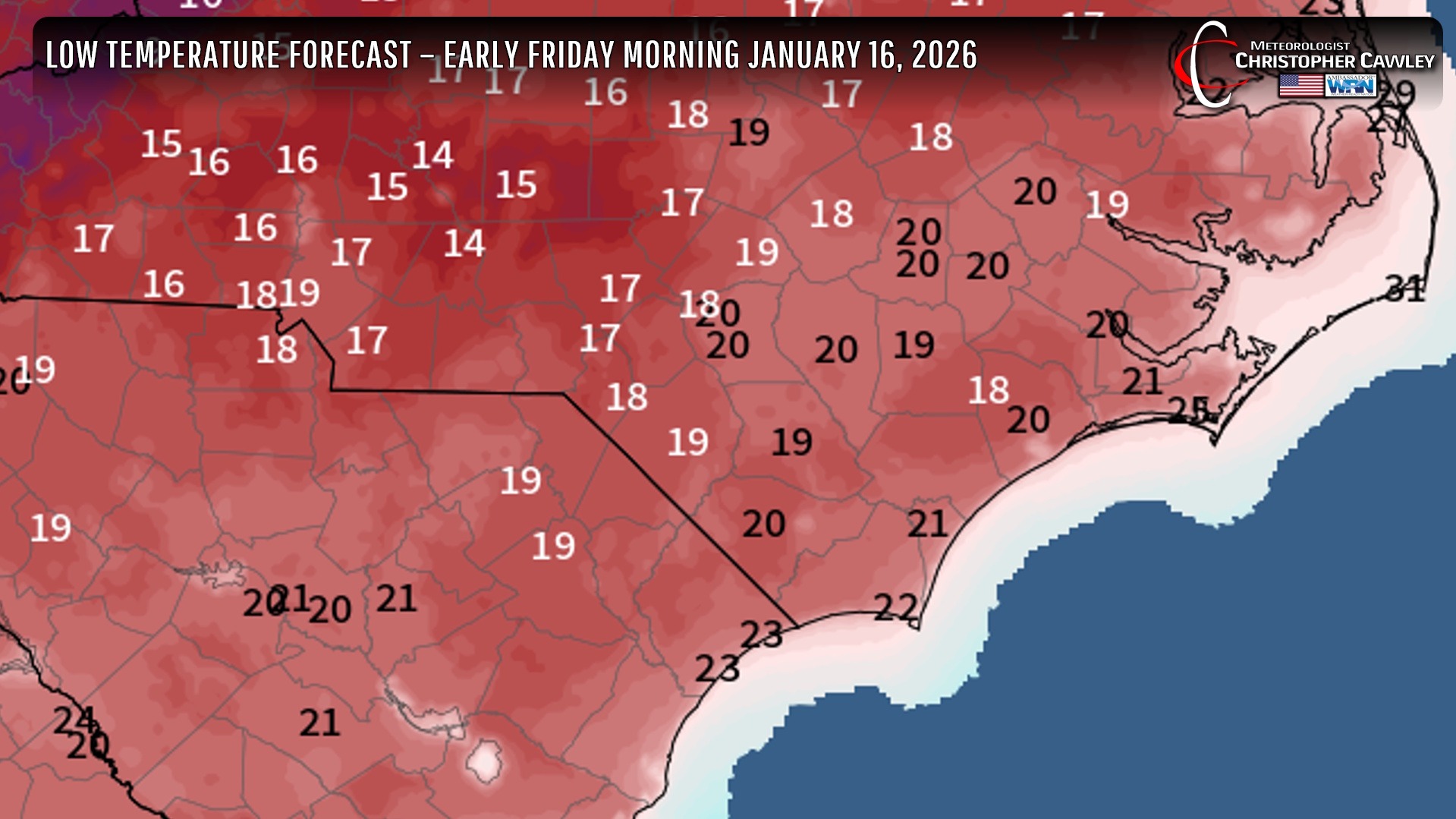
We have a “people, pets, pipes” alert for Thursday night into early Friday as our temps drop into the teens. Wind chill values will drop to between 10-15.
Despite full sunshine on Friday, our highs will only be in the lower to middle 40s.
“Warmer” air starts to push in Friday night and our lows will “only” be in the upper 20s early Saturday, with Saturday afternoon highs reaching the upper 50s.
Then the next powerful (but dry) cold front moves through late Saturday night. Sunday will feature cold temps and a variably cloudy sky … at this point … however some of the modeling really wants to push some moisture in here with a wave of low pressure off the coast. I’m not ready to jump on board the “snow train” quite yet. After that, cold and dry going into next week.
Here’s your Freedom Insurance Today-plus-Five Forecast!

–Meteorologist Christopher Cawley