CCN Weather Update for Wednesday February 11, 2026.
This weather update is sponsored by Freedom Insurance of Whiteville. You can trust Freedom Insurance to give you clear blue skies when it comes to home, car, boat, or whatever insurance you need. Let Freedom provide customized coverage to keep you and your family safe. Contact Freedom today at 910-640-2828!
Here’s today’s Bottom Line:
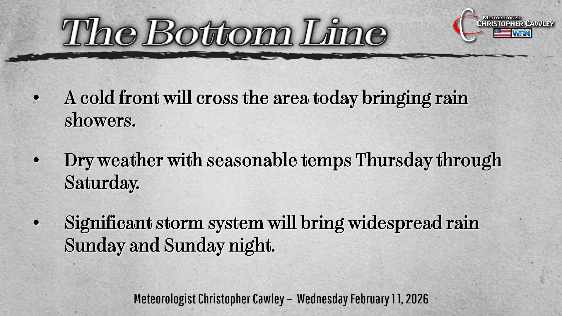
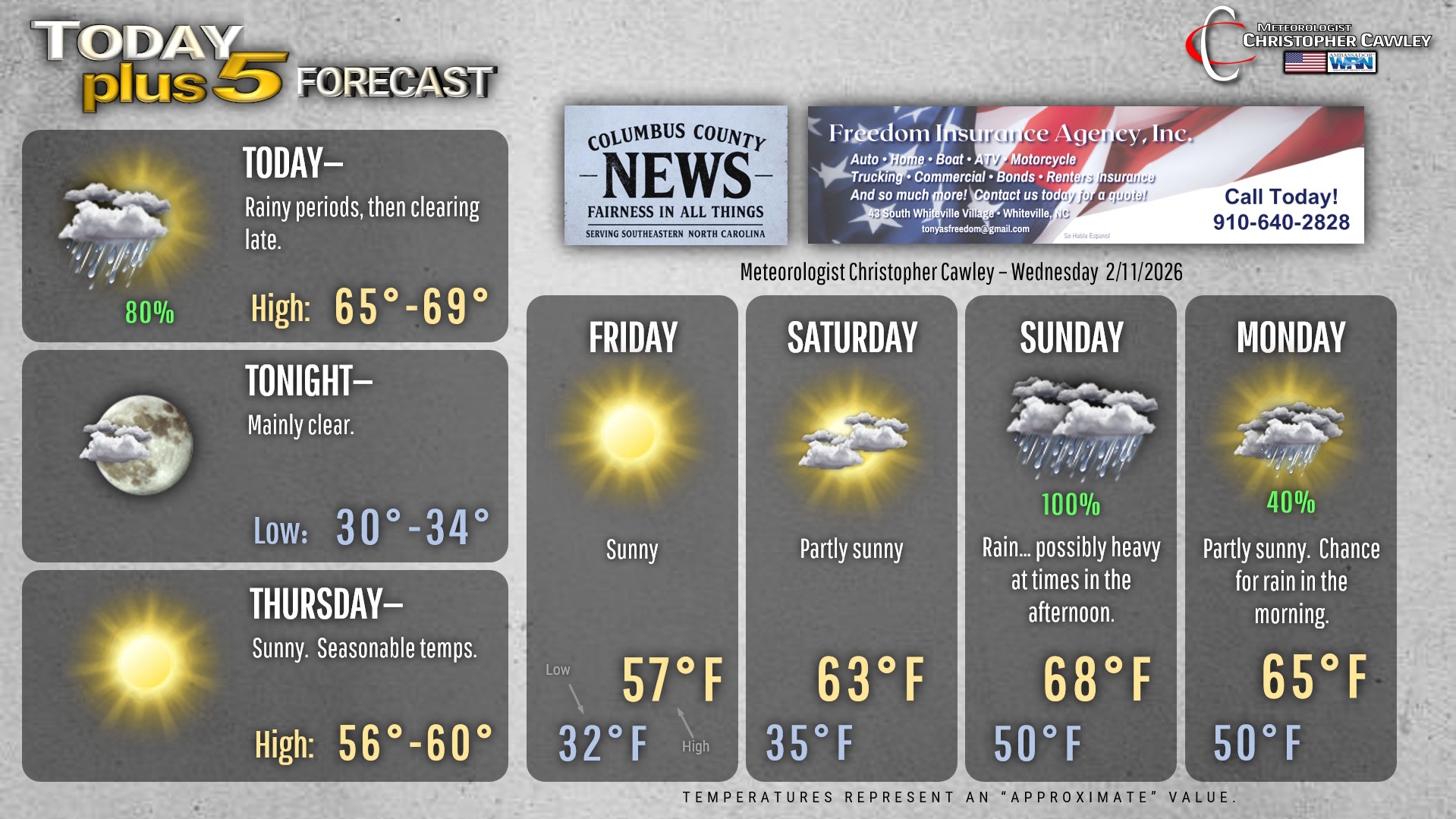
Today will be another warm day across the area, but we’re going to get some rainfall as a cold front drops southeast across the state this afternoon. Ahead of this front rain is expected from roughly mid-morning through mid-afternoon. Rainfall amounts won’t be all that significant, no more than about a quarter of an inch.
After the frontal passage, our skies should start to clear, such that by this evening we’re clear and dry. Temps will return to seasonable normal values late tonight through Thursday and Friday.
There may be some isolated patches of black ice early Thursday morning as temps drop to around 32 degrees. That should cease being an issue fairly quickly as we’ll have full sunshine on Thursday with, again, seasonable temps in the upper 50s.
Friday will be quiet with early morning lows in the lower 30s, afternoon highs in the upper 50s … right where we should be this time of year.
Clouds will be on the increase for Saturday ahead of a significant storm system that will impact our area this weekend.
While there is some disagreement in the modeling, a consensus is coming together. A warm front is likely to lift northward over the area Sunday morning. Abundant moisture lifting northward “up and over” this front will lead to rain breaking out in the pre-dawn hours on Sunday. The warm front will bring a wave of rain. Low pressure will likely lift northeast from central Alabama through the GA/SC/NC border area, through northern NC, and off the coast of Virginia Beach by Monday morning. A cold front will get dragged across the area at some point either late Sunday or Sunday night. We’re likely to see periods of rain throughout the day Sunday, and the rain may be heavy at times later Sunday afternoon through Sunday night. Rain should quickly taper off early in the morning on Washington’s Birthday, aka President’s Day, with increasing sunshine through the day.
We’ll be firmly in the warm sector of this storm through the event. There will be no frozen precipitation whatsoever. I wouldn’t be surprised if we hear some thunder late Sunday afternoon into Sunday night.
Rainfall amounts could be somewhat significant. The latest model blends point to between 1 and 2 inches of rain for the event. This has trended down just a bit over the past 24 hours, but as modeling comes into better agreement, I believe we’ll see things get fine-tuned over the next couple of days.
We’ll have dry weather with temps running quite a bit warmer than normal into next week.
Here’s your Freedom Insurance Today-plus-Five Forecast!
–Meteorologist Christopher Cawley