Good evening, Meteorologist Christopher Cawley here with your weather update for Monday November 18, 2024.
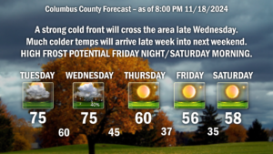
Unseasonably warm temps on Tuesday ahead of a strong cold front that will crash through the area late Wednesday. Warm, southwest breezes will jump our temps well into the mid 70s across the county. Clouds will be on the increase through the day, and I believe by suppertime we’ll be generally overcast. Shower chances develop Tuesday night, especially after midnight… but I’m going to pin those chances at roughly 30% to 40%.
Wednesday will be breezy and warm with occasional showers, mainly through the morning hours. I don’t think we’re going to see an awful lot of rainfall from this system. Most of the modeling is coming in at less than a quarter of an inch total, and there’s the possibility that some areas of the county won’t get any rain at all. If I were to give percentages, I’d go with 30% to 40% (I put 40% on the graphic).
Then our temperatures tumble and we welcome the coldest air of the season. Finally some winter-like cold. Bright sunny skies are likely Thursday through the weekend, thanks to Canadian high pressure in place with afternoon highs in the mid to upper 50s into the weekend and lows deep into the 30s. These are normal values for late January, not late November. But if you’re excited for a taste of winter to help motivate you with holiday decorations, here ya go.
Oh, yeah, it’s going to be cold at Legion Stadium Friday night, so bundle up and go support the Wolfpack!
FROST THREAT:
Thursday night: Isolated/patchy
Friday night: Scattered
Saturday night: Scattered to widespread
Sunday night: Isolated/patchy
Longer-range modeling shows a definite transition to winter across portions of the eastern U.S. with cold, Canadian air plunging southward around low pressure near Lake Huron. Another organizing low on the southern jet stream appears that it could bring the first real winter snows for the mountains of NC, as well as most of Kentucky and the Ohio valley, into Pennsylvania and New York, by the 1st of December.
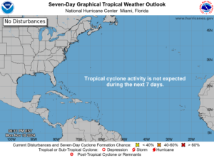
Taking a look at the tropics, things are now quiet. What used to be Sara is going to lift northward into the Gulf of Mexico and bring enhanced rainfall along the Florida panhandle through midweek. It’s not really even a low pressure center anymore, it’s more of an open trough attaching to the cold front that will move through our area. Sara is no more.
No other tropical activity is expected… and the season comes to a close on November 30th.


