Hi everyone, Meteorologist Christopher Cawley here with your daily weather update for Tuesday December 17, 2024.
We’re off to a foggy start in places thanks to a lot of low-level moisture locked in place. It’s going to take some time for the fog and low clouds to burn off today, and while I think we’ll see plenty of sunshine this afternoon, the morning hours are going to be kind of cloudy and cool.
I’m going to be optimistic and go with a belief that the low clouds will burn off by late morning. This would result in our temps jumping deep into the 70s this afternoon. There is the potential that the cloudiness hangs tough given the weak December sunshine, and if that’s the case, my high temperature forecast for today will be “busted.”
Rain chances start to increase tonight and Wednesday, reaching a crescendo late Wednesday evening and into Wednesday night. An area of low pressure gets organized over the Ohio Valley by early Wednesday morning. A weak frontal boundary will be draped across central North Carolina and this is likely to bring clouds and a few spotty showers to the area late Tuesday night into early Wednesday.
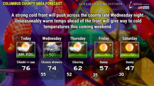
The storm system rapidly strengthens as the low moves across Pennsylvania during the day on Wednesday. A cold front will extend southward from the low center, reaching the NC mountains by time we sit down to supper on Wednesday. A southerly flow of warm and humid air will become established across the county on Wednesday. This will result in partly sunny skies but the 50/50 shot at rain showers at any given point in time. Wednesday won’t be a washout by any means but you might just want to keep an umbrella nearby.
The front crosses the area during the overnight Wednesday night/Thursday morning. The front is likely to bring a line (or perhaps multiple broken lines) of showers to the area. Some of the modeling wants to push enough instability our way to hint at some thunder, but I doubt it very seriously. While some of the showers may have some briefly gusty winds thanks to modest shear values, the severe threat is essentially zero.
The front pushes through early Thursday with a sudden wind shift and rapidly clearing skies. Despite full sunshine in the afternoon, our highs on Thursday will probably occur around midday, with temps falling in the afternoon.
Strong high pressure of Arctic origin then takes hold through the weekend and into next week. A reinforcing shot of colder air pushes through later Saturday in the form of a weak, dry frontal boundary. Not shown on the graphic below is the fact that our highs may not get out of the 30s on Sunday… with temperatures early Monday morning in the upper teens. Brrr. At least the kiddos are off of school, so no bus-stop worries.
LOOKING AHEAD TO CHRISTMAS: Normally I don’t like to project so far out in time … Christmas is still 8 days away… but all of the available modeling points to a dry Christmas with seasonable temperatures. The model blend suggests that highs will be around 60 with morning lows in the upper 30s. No precipitation is expected after the frontal passage this Wednesday night. The chances for a White Christmas… are zero. This will be the 35th year since we’ve had a White Christmas in Whiteville.
Ok folks, that’ll wrap it up for today’s weather blog. As always, I hope you have a wonderful day, THANK YOU for reading, and take care.


