Hey folks, welcome to the Tuesday edition of the CCN Weather Update!
Sponsoring the CCN Daily Weather Update is Freedom Insurance of Whiteville, NC. Freedom Insurance believes in providing peace of mind for you and your loved ones. Whether you’re looking to safeguard your home, car, health, or business, Freedom can offer tailored insurance solutions to meet your unique needs. Contact them today at 910-640-2828 or stop in at their office across from Lowe’s in Whiteville.
STATISTICS FOR WHITEVILLE – Monday February 10, 2025.
High: 52.9°F at 12:01 AM (normal is 57)
Low: 38.3°F at 11:59 PM (normal is 33)
Precip: 0.00 in
View live, real-time weather data for Whiteville on my College Street Weather Station.
Here’s your Bottom Line for today…
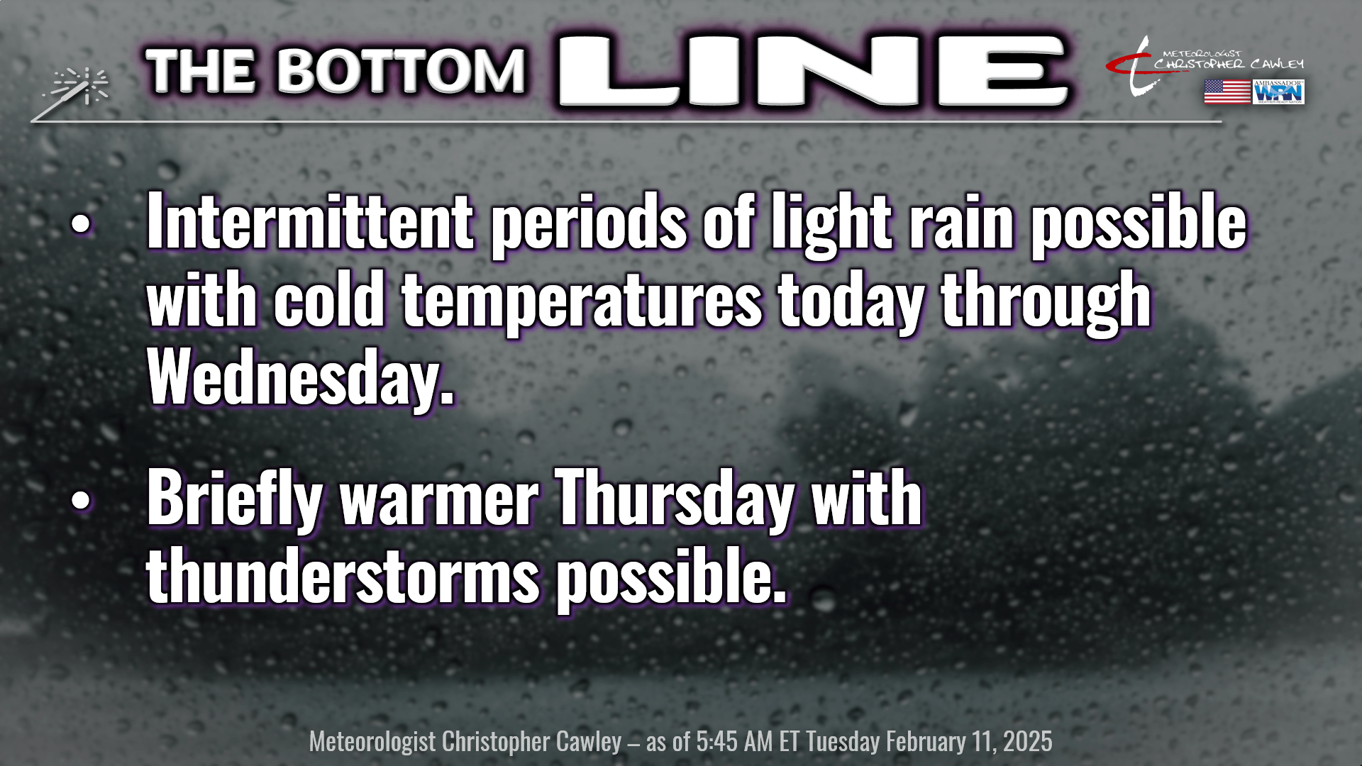
Overall low-confidence forecast trend continues today through tomorrow. Wedge stays firmly in place today. A trough (like a weak frontal boundary) is becoming established along the coast as I write this, while the main frontal boundary resides far to our south.
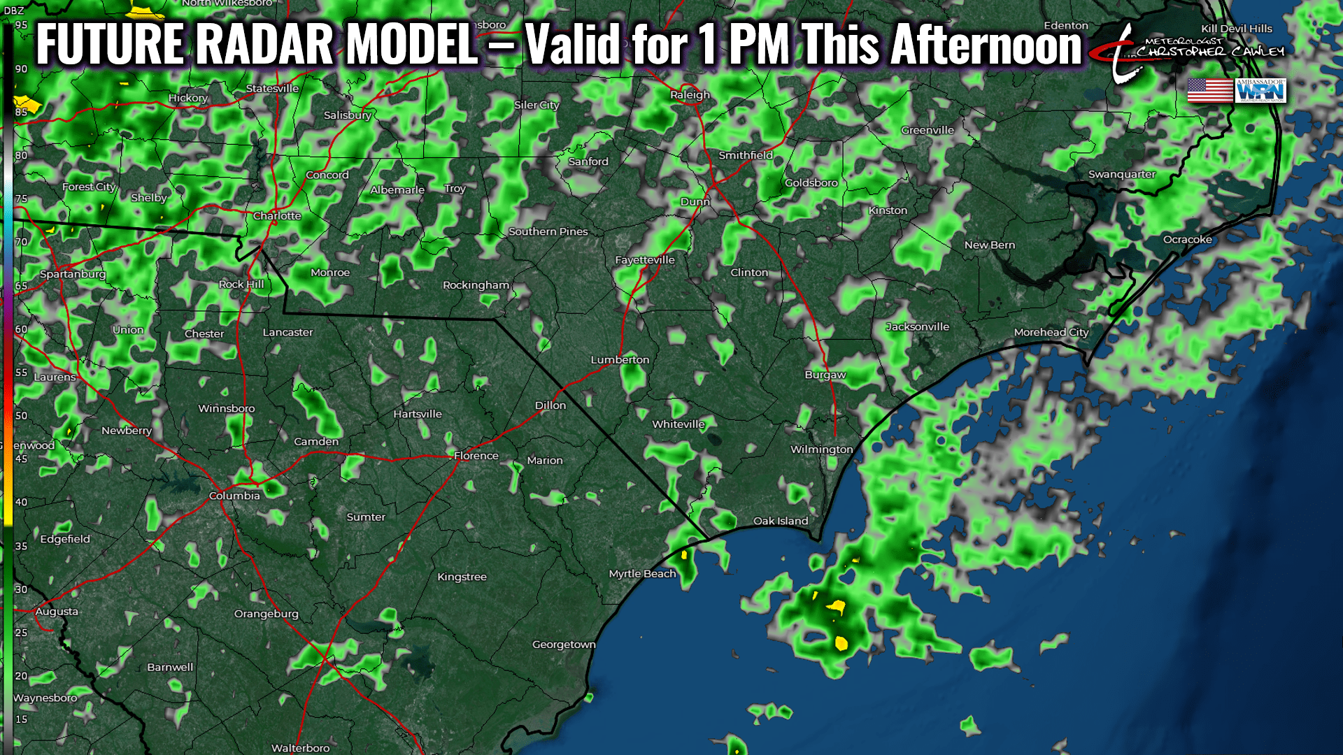
A lot of “overrunning” is expected to develop across the Carolinas today. Overrunning is a situation where you have warm, moist air pushing “up and over” colder, moist air at the surface. This results in the lift that is needed to generate precipitation. The best forcing/lift is likely to be to our north and west today, but I do expect some spotty areas of light rain across the county today. The best timing appears to be from mid-morning into early afternoon, with just cloudy skies in the meantime. The overall atmospheric saturation will be kind of shallow today, so whatever rain that does fall isn’t going to amount to much. Maybe a tenth of an inch at the most.
Here’s a future radar model for 1 PM today. This may be a little bit “overdone,” which is a tendency the NAM3k model has.
Temperatures today … I have more confidence in my ability to fall down a flight of stairs than I do with this temperature forecast. Large gradients are likely to develop with the presence of that coastal trough. Today will be the case where some areas closer to the coast could rise into the upper 50s, maybe even around 60 for places like Southport, Ocean Isle Beach, Myrtle Beach. Meanwhile, across ColCo, temps *should* remain stuck in the upper 40s to around 50. If the trough is able to push a little bit inland, that breaks down the wedge just a little bit, and our temps could jump into the 50s. I put a “48” on the graphic for today.
We’re kind of in a holding pattern for tonight with a continued threat for spotty light rain, along with clouds and some areas of fog. I expect our lows to drop to the upper 30s to around 40.
Wednesday: Wedge breaks down a little bit as a complex area of low pressure and a frontal system gets closer and closer. A warm front will be juuust to our south, likely draped across central SC during the day. I expect more coverage of generally light rain on Wednesday… but get on the other side of I-95 and the rain becomes much more widespread and soaking. That’s just the way it’s going to work out. As the wedge starts to break down, our highs will reach the mid 50s.
Wednesday night: The warm front slowly… and I mean slowly… lifts to the north over the area. Occasional showers are likely with this frontal passage, and while our lows could drop into the mid 40s, temperatures will slowly rise toward daybreak.
Thursday: Warm front pushes into northern North Carolina into southern Virginia. We end up in a warm sector for no more than about 6-8 hours before a relatively strong cold front moves through. Showers are likely with the passage of the cold front, and the latest profiles suggest the potential for thunderstorms as well. It’ll all be in the timing of the frontal passage and what instability can form. Profiles suggest plenty of deep layer wind shear, so if we can get a little bump in the instability, we could see some thunderstorm activity Thursday afternoon.
Front clears the coast by early Friday and we’ll FINALLY SEE SOME SUNSHINE on Friday. I’m going with mostly sunny skies and seasonable temps on Friday… highs in the 50s.
Don’t get too used to the dry weather. ANOTHER frontal system moves quickly toward the eastern United States. A warm front lifts north over the area on Saturday, and that brings more showers. Warm sector conditions again on Sunday before the next cold front crashes through, with another threat for thunderstorms. Predictability is too low at this point as to severe weather potential.
Once THAT front clears the coast, our temperature roller-coaster ride appears to flatten out for at least a week or so… with temperatures averaging out below seasonal normal values.
The below chart is the European ensemble graph for temperatures going through the 24th. On the whole, temps run below normal.
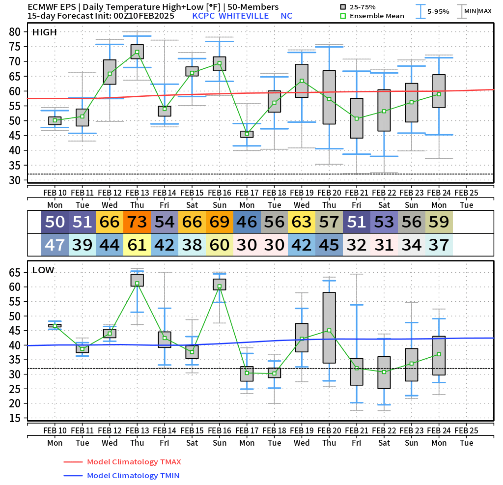
The deterministic modeling — Euro, GFS, and Canadian — all point to yet another significant weather system dominating the eastern US at some point NEXT week. The Canadian modeling suggests a “bomb cyclone,” develops late in the week… how thrilling that could be.
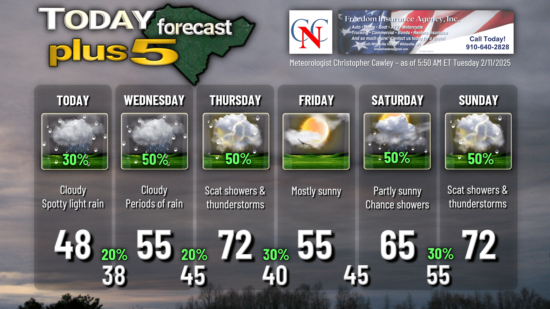
Here’s your Freedom Insurance Today-Plus-5 forecast for Columbus County.
That wraps up today’s report… thank you for reading! Try to stay warm and dry today, and make it a great day. As always, take care.
~Meteorologist Christopher Cawley