Hello everyone and welcome to your CCN Daily Weather Update for Friday March 28, 2025.
This weather update is sponsored by Freedom Insurance of Whiteville. Protect what matters with Freedom Insurance. Life is full of surprises, but with Freedom Insurance, you’ll always be prepared. Whether it’s your home, car, business, or health, we provide customized coverage to keep you and your loved ones secure. Contact Freedom today at 910-640-2828!
STATISTICS FOR WHITEVILLE – Thursday March 27, 2025.
High: 70.8°F at 4:42 PM (normal is 69)
Low: 42.1°F at 7:24 AM (normal is 44)
Precip: 0.00 in
Average Humidity: 29%
View live, real-time weather data for Whiteville on my College Street Weather Station.
Here’s today’s Bottom Line

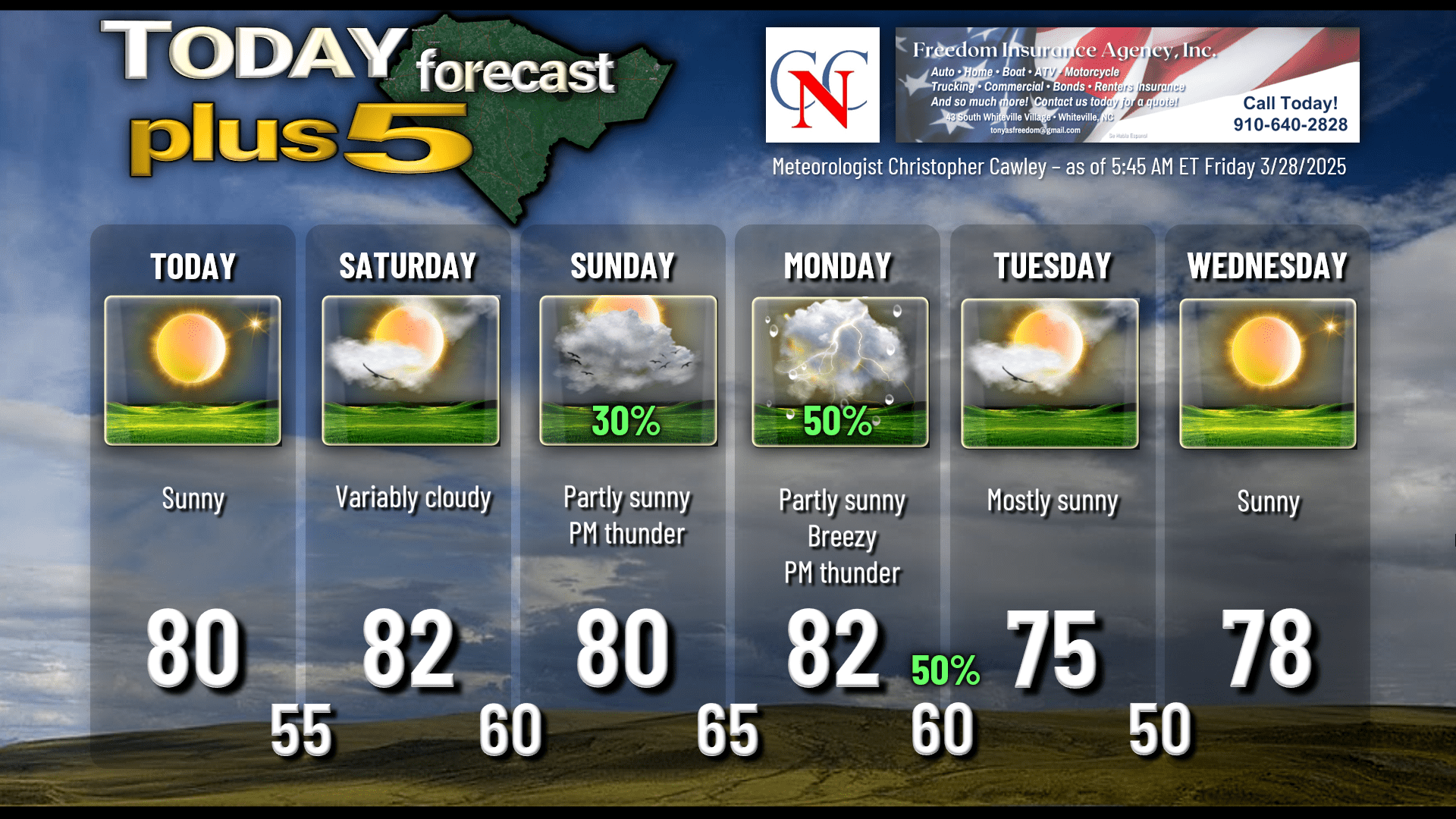
More dry weather. More high fire danger conditions. High pressure will push offshore early this morning allowing for significantly warmer temperatures this afternoon than we’ve had the past few days… our highs will be around 80 or possibly even into the lower 80s. The high fire danger continues in spite of the fact that our relative humidity values will be a bit higher this afternoon (yesterday’s average RH for Whiteville, on my weather station, was 29 percent). Gusty winds are likely to develop as a sea-breeze boundary moves across the county late this afternoon.
High pressure centered east of the Carolinas on Saturday will tend to “ridge backwards” toward the Georgia coast. The surface wind flow will be from the southwest and then from the south by later Saturday into Saturday night. This allows significantly more moisture to pump into the area, resulting in much higher humidity values. Saturday night will actually feel somewhat “muggy.”
Surface low pressure will develop and move into Kansas on Sunday. The low will rapidly strengthen as it makes a beeline toward northern New England by Monday. To the south of the low, a cold front will push across the area sometime between late Monday afternoon and early Tuesday. Guidance is finally starting to hone in on the front passing late Monday night, but there’s still a bit of a spread that I’d rather not see. Ahead of the front will exist an abundance of moisture, the likes of which we haven’t seen in a while… air conditioners may hum Sunday afternoon through Monday night. A few showers and possibly a thunderstorm are possible for Sunday afternoon (I’m keeping my forecast at 30%), but there exists a much better chance for thunderstorms Monday afternoon into Monday evening. We’ll be looking at steadily increasing instability Monday afternoon, and a quickly increasing wind shear Monday afternoon into Monday night. The source of lift would be the frontal boundary in the vicinity. The Storm Prediction Center maintains a 15% severe risk for Columbus County on Monday — mainly Monday afternoon into the evening hours. The severe risk would be higher if a convective line moves through in the mid-afternoon than it would be passing Monday evening. Too soon to call, and the last three systems now have grossly underperformed compared with the available modeling, so I’m not exactly ready to jump on the bandwagon quite yet.
The front clears the coast by Tuesday morning at the latest, bringing an end to precipitation chances for the foreseeable future.
Here’s your Freedom Insurance Today-plus-Five forecast:
That will conclude today’s report. Thanks for reading, and as always, take care.
~Meteorologist Christopher Cawley