CCN Weather Update for Friday June 13, 2025.
This weather update is sponsored by Freedom Insurance of Whiteville. When severe weather strikes, with Freedom Insurance you will always be prepared. For home, car, boat, or whatever you need, Freedom can provide customized coverage to keep you and your family safe. Contact Freedom today at 910-640-2828!
Here’s today’s Bottom Line
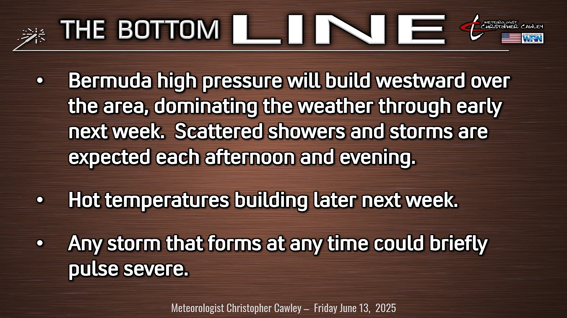
I sure wish I had something more interesting to write in this blog other than the same thing we’ve been talking about for what seems like days on end. “Sunshine with a chance for showers and thunderstorms this afternoon and evening.”
So to keep this fresh I thought today I’d write about a different type of moisture measurement called “precipitable water.”
We measure moisture in the atmosphere by relative humidity, by dewpoint, and by precipitable water, abbreviated PWAT or PW.
PWAT is a measure of the total amount of water vapor in the atmosphere, typically written as the depth of liquid water that would result if all the water vapor in a vertical column (think of a “box” of atmosphere) were to condense. It essentially tells us how much moisture is present in the air at a given location.
PWAT is a key factor in weather forecasting and climate studies. It’s used to predict the potential for rain or snow, understand atmospheric rivers, and assess the strength of winter storms.
PWAT is used to estimate the amount of moisture available for precipitation. It does not tell us how much rain (or snow) will fall; only the total amount of moisture available.
The value is usually measured in inches.
0.50 inch or less = very low moisture content
0.51 to 1.25 inches = low moisture content
1.25 to 1.75 inches = moderate moisture content
1.75 to 2.00 inches = high moisture content
2.00 inches or higher = very high moisture content.
Below are some forecasting implications of precipitable water.
Severe Storms: Atmospheric moisture determines whether a supercell storm will be HP (high precipitation), Classic, or LP (low precipitation). HP supercells often have PW of 1.75 inches or above and LP supercells often have a PW value of less than 1 inch. When we do get supercells here, they’re often in the “classic” or “HP” categories.
Flooding potential: A particular area, such as Columbus County, has a climatological “normal” PW for a certain time of year. In cases where the PW value is 2 to 3 or greater times more than the normal value, flooding becomes more likely when a heavy precipitation event occurs.
Lightning: In a highly unstable environment, high PW will lead to storms that produce an abundant amount of lightning.
Today’s PW values are around the 2.00 inch range, as shown on the map here. Areas in purple are 2.00+, while the dark blues in Columbus County are between 1.90 and 2.00 inches. The “+” sign is over Whiteville, where the model depicts a PWAT of 1.96 inches.
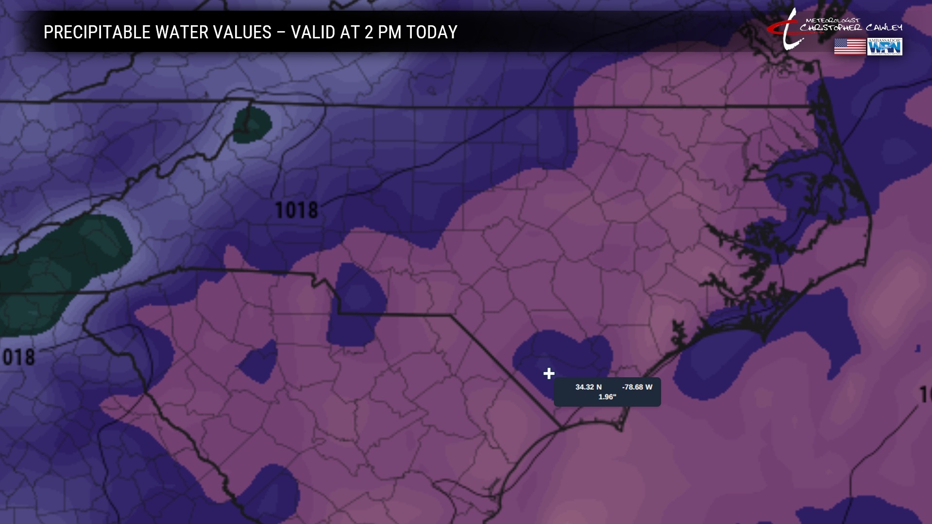
So what does this mean? This means there is gobs of moisture available for showers and thunderstorms over the area. We get “lift” (or “spark”), which is caused by a multitude of factors not the least of which includes outflow boundaries from decaying or dissipated thunderstorms. That lift, combined with atmospheric instability, and the abundant moisture, means local thunderstorms with a period of intense rainfall and tons of lightning.
And that’s going to be the case each afternoon and evening going into next week.
Indications are stronger that the high pressure ridging will begin to put a lid on thunderstorm chances as we go into the middle of next week… and rockets are strapped to our temperature profiles.
“Sunshine and storms.”
TROPICAL OUTLOOK: Massive ridges of high pressure dominate the tropical Atlantic, Caribbean, and Gulf. No development expected for the next 7 days.
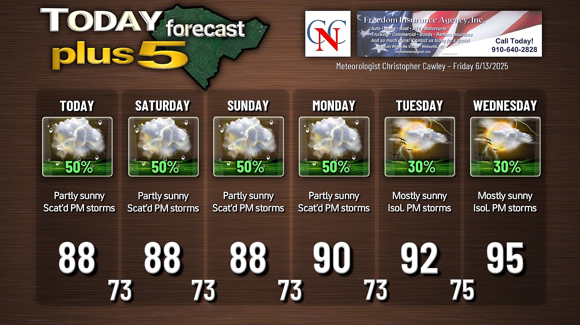
Here is your Freedom Insurance Today-plus-Five Forecast:
–Meteorologist Christopher Cawley