CCN Weather Update for Thursday July 3, 2025.
This weather update is sponsored by Freedom Insurance of Whiteville. Declare independence from your worries with Freedom Insurance. For home, car, boat, or whatever you need, Freedom can provide customized coverage to keep you and your family safe. Contact Freedom today at 910-640-2828!
Here’s today’s Bottom Line
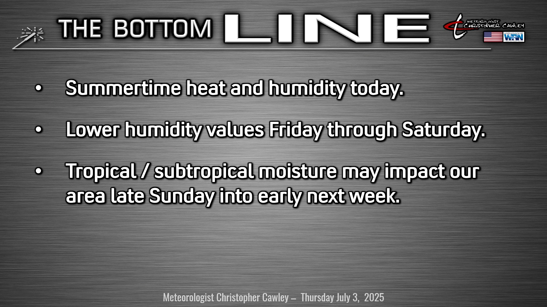
A frontal boundary draped along the coast will slowly — seriously slowly — push offshore later today. I can’t rule out a renegade shower or storm today, but on the whole we should be dry.
Relatively dry conditions for Independence Day with our area pinched between a large ridge of high pressure over the Mississippi Valley and an area of low pressure pushing through New England. Yes, systems that far away can have impacts here locally. We will have a resultant northwest wind flow, which sometimes leads to severe thunderstorms here, but I don’t think this will be the case on Friday. There will be an abundance of dry air (not something I write very often in July), and overall rain chances will be low on Independence Day and into Friday night. I can’t rule out some natural fireworks, but I highly doubt it. It’ll be a hot day, but humidity will be relatively low for this time of year, so it won’t be all “that bad.”
Saturday – Surface high pressure will be in firm control for our weather, while that potential tropical low lurks offshore. The low kind of wanders off the coast on Saturday while we remain dry with still relatively low humidity for this time of year. It’ll be hot, that’s for sure, but again, not unbearable. UV index will be off the top of the charts though.
For the end of the weekend, we have to watch whatever develops off the Georgia/SC coast by Friday/Saturday. At this point it’s pretty much a given that some kind of low pressure center will develop (all of the global models point to this happening). From there, several question-marks appear. Given the uncertainty in the potential storm track this far out, I’m going with a 50/50 chance for rain Sunday-Tuesday. The low is likely to be a very slow-mover, and if it takes an onshore track, abundant rainfall could be the result. Nothing is certain at this point, and it’s really a “no confidence” forecast after Saturday.
TROPICAL OUTLOOK: Global models show an area of low pressure spinning up on the frontal boundary draped offshore sometime late Friday or Saturday. This may develop into a tropical or subtropical depression this weekend.
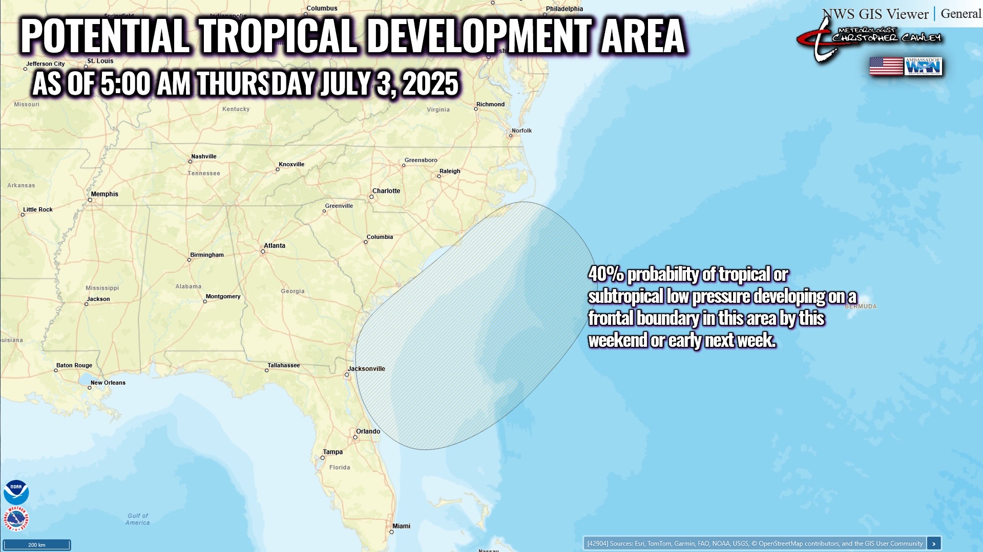
Movement is likely to be initially relatively slow and somewhat erratic, according to the guidance. The European and ICON modeling shows this lifting northward making a landfall along the NC/SC state line; the GFS keeps the low offshore and dissipating by Tuesday. The ICON paints a stronger system than does the European.
Obviously an inland track means copious rainfall for our area Sunday and Monday. Modeled precipitable water values by Sunday afternoon are exceptionally high, so there is the potential for some heavy rainfall here late in the weekend and early next week.
Should the GFS verify, then the offshore track means less rainfall potential this weekend and early next week.
As mentioned above, I’m going with a 50/50 chance for showers/storms Sunday-Tuesday based on this uncertainty.
Stay tuned…
Here is your Freedom Insurance Today-plus-Five Forecast:

–Meteorologist Christopher Cawley