CCN Weather Update for Saturday January 10, 2026.
This weather update is sponsored by Freedom Insurance of Whiteville. You can trust Freedom Insurance to give you clear blue skies when it comes to home, car, boat, or whatever insurance you need. Let Freedom provide customized coverage to keep you and your family safe. Contact Freedom today at 910-640-2828!
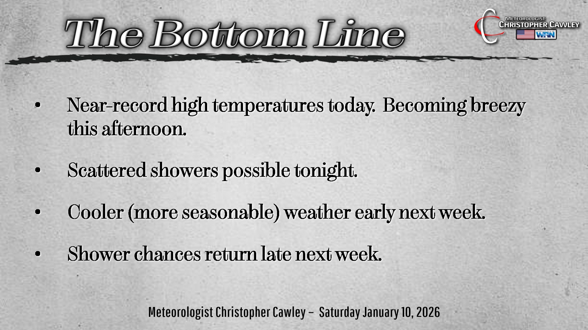
Here’s today’s Bottom Line:
Warning… today’s blog is gonna take a minute to read. It’s long!
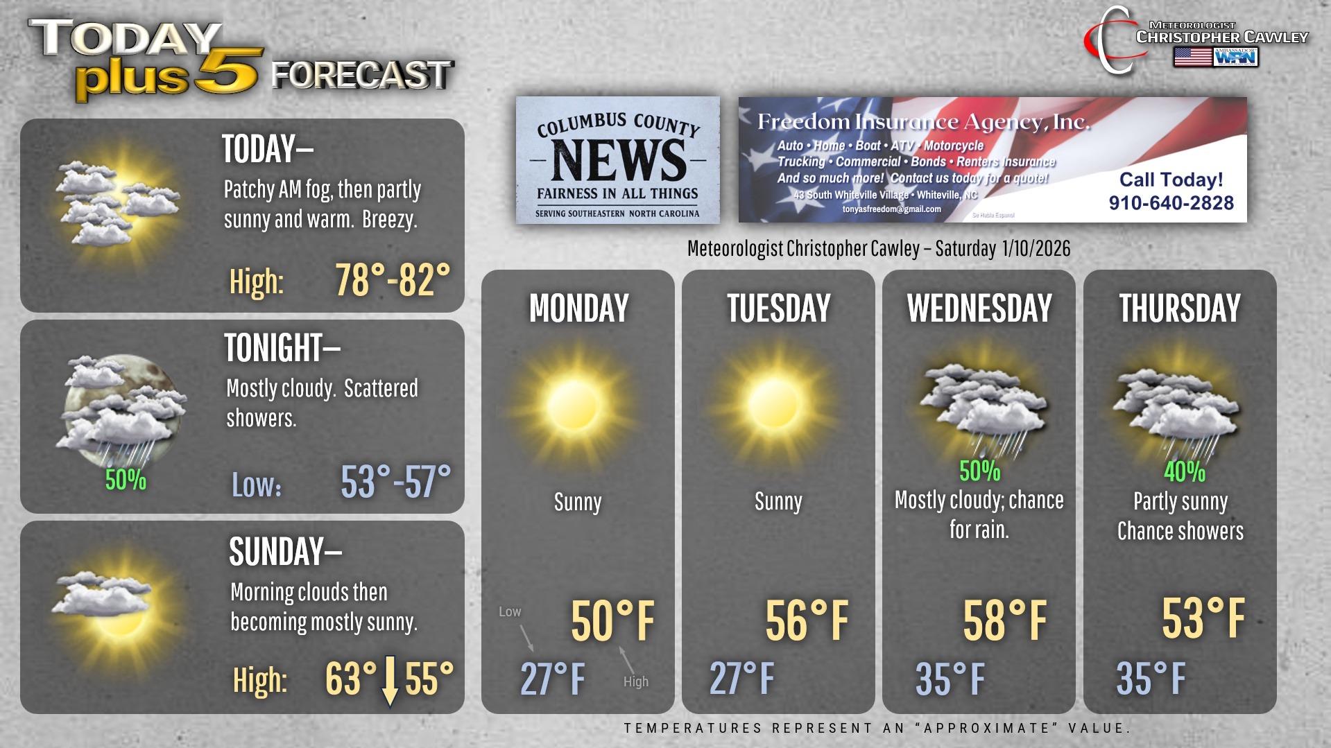
An unseasonably warm and rather humid air mass is firmly place over the area today. It will likely become somewhat breezy this afternoon in an increased “pressure gradient” between high pressure offshore and an approaching cold front. We’re starting off with clouds, fog, and perhaps a few patchy areas of light rain… but I think we’ll see considerable sunshine as we work through the day. This will help temperatures push to near 80 degrees.
The front moves through tonight. The short-term modeling suggests there will be some scattered showers ahead of and along the frontal boundary. Rainfall will be light, generally no more than a tenth of an inch.
A secondary front moves through on Sunday. High temperatures will occur early in the day. We will start off with lots of clouds but after the secondary front moves through, skies rapidly clear. Temps will be falling through the afternoon.
Clear skies for Sunday night… and with deep, Arctic air pushing in, our temperatures go down-down-down into the mid and upper 20s. Temps at the bus stop Monday morning will be in the upper 20s.
Monday and Tuesday will have high pressure dominating our weather, leading to dry conditions. Monday will be chilly… highs only around 50, but a nice rebound into the mid/upper 50s looks likely for Tuesday.
The next frontal boundary then moves through on Wednesday with some showers possible.
Things get a little bit interesting toward the end of the forecast period in that the European model wants to develop a low off the Carolina coast going into Friday. There will be some colder air pushing in Thursday into Friday… but I think at this point whatever precipitation activity toward the end of next week will be liquid.
But things could get… interesting.
WILL IT SNOW??? “Hey Chris, this dude on Facebook said it’s gonna snow!”
Ok here’s where we’re at. The overall pattern is changing, as I mentioned in yesterday’s report, but let’s talk about expectations.
Through the end of January, we’re going to see something we haven’t seen much this season so far, and that is a pattern more favorable for frozen precipitation.
That does NOT mean “snow” is a certainty, especially here in southeast NC, but it does mean that overall patterns are more favorable.
First of all, what is a “measurable” snowfall? A tenth of an inch. That’s barely noticeable in the grass. But that counts as measurable snow. Zero impacts.
So what is the longer-range modeling showing? If you recall over the past year-plus I have spoken A LOT about ensemble modeling vs “single-image” deterministic models (the kinds that people on social media like to share). Anyway, looking at ENSEMBLE model data, yes there is the chance for measurable snowfall over Columbus County before the end of the month. The latest European ENSEMBLE model consensus has 7 out of 50 members showing “measurable” snowfall within the next 10 days. That comes out to a 14% chance. The GFS ENSEMBLE consensus has 5 out of 30 members with “measurable” snowfall (none more than 1 inch) over the next 10 days… a 16.67% chance.
“So you’re saying there’s a chance!” Yes, I’m saying there’s a chance. There’s also a chance that everyone reading this blog wins the lottery and becomes a multimillionaire.
Anyway, NONE of this represents a forecast. It IS “pattern recognition.”
To get winter weather here in the coastal Carolinas, we need very cold Arctic air to be pouring down over the area thanks to high pressure to the north. Then we have to have low pressure on the southern jet stream that progresses from southern Georgia to a position off the coast. It then has to “thread the needle” perfectly with position offshore. Too close to the shore, we get cold rain or mixed precip. Too far offshore, we get nothing whatsoever. The storm of January 21-22, 2025, demonstrated what happens when all of the stars line up just perfectly. Will that happen again? I mean, it “could.” The chances are quite slim.
In looking at extended outlooks, modeling beyond 7-10 days is, at best, a crapshoot. Even the vaunted European model… after 7-10 days it’s 50/50 at best. The single images that you see on social media (those are called “deterministic” models) will change very often as time progresses. What looks all bold and exciting this afternoon could be a nothingburger tomorrow afternoon.
The display on your phone apps is nothing more than deterministic model data. Beyond 7-10 days, it’s for entertainment purposes only.
Sadly, the hype train does include professional meteorologists, one in particular I won’t name here but is known for very splashy graphics on Facebook. That negatively impacts the credibility of everyone in the business.
The bottom line is this: We’re transitioning from an unseasonably warm pattern into one that COULD support winter weather. That alone is important… but does NOT mean that measurable snowfall will occur here. Regardless of what you see on social media.
Ok, that went on longer than it should have, so without further ado, here’s your Freedom Insurance Today-plus-Five Forecast:
–Meteorologist Christopher Cawley