CCN Weather Update for Thursday January 15, 2026.
This weather update is sponsored by Freedom Insurance of Whiteville. You can trust Freedom Insurance to give you clear blue skies when it comes to home, car, boat, or whatever insurance you need. Let Freedom provide customized coverage to keep you and your family safe. Contact Freedom today at 910-640-2828!
Here’s today’s Bottom Line:
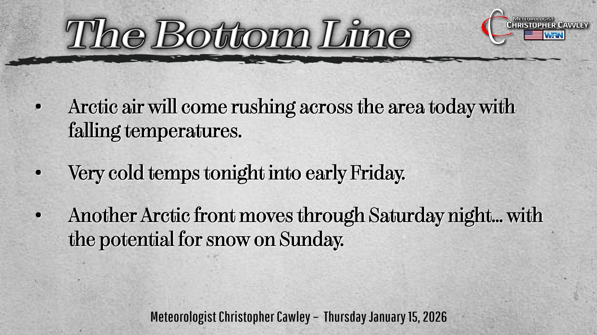
Two big things to talk about today.
BITTERLY COLD TEMPERATURES TONIGHT INTO FRIDAY.
I’m issuing a totally unofficial “People, Pets, Pipes” alert for tonight into early Friday.

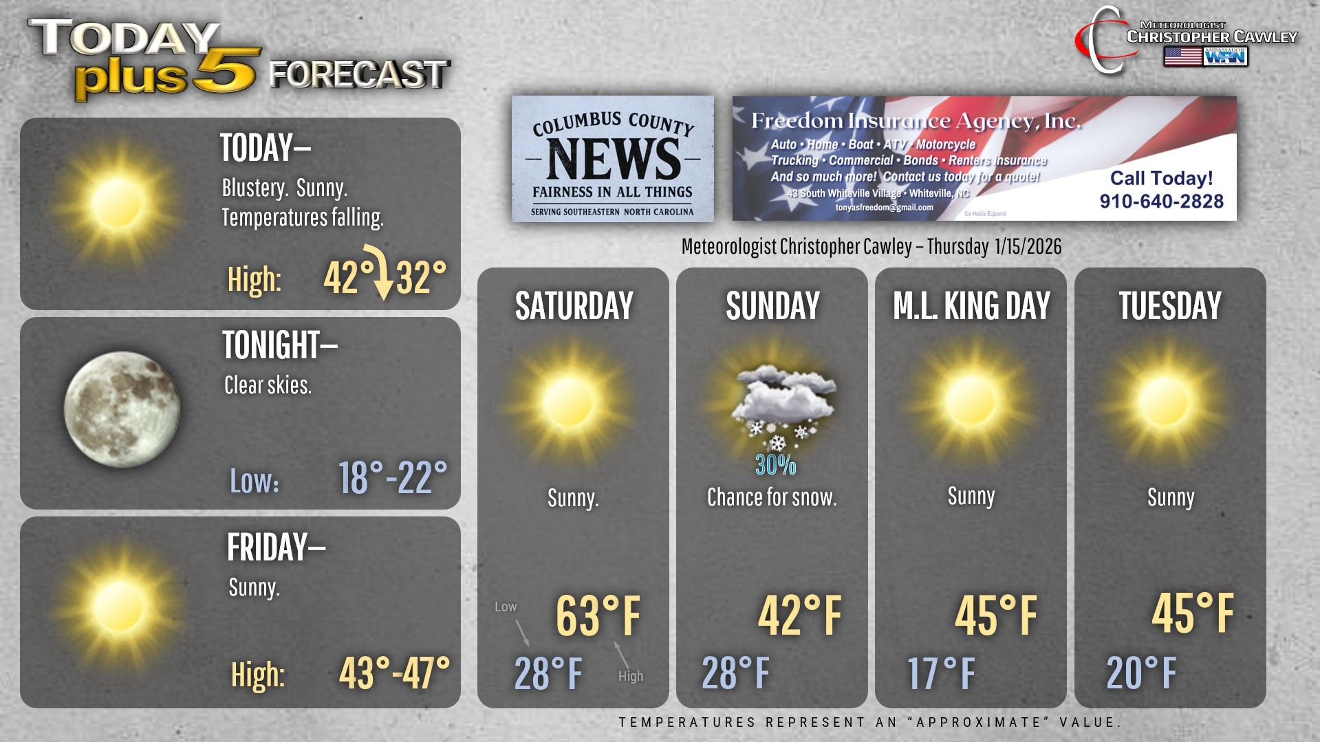
Today will be blustery and cold. We’ve already had our “high” for the day… temps will be falling throughout the day. When you sit down to eat supper tonight, it’ll be in the 30s.
Then the sun goes down and the thermometer will go down with it. Lows tonight (early Friday morning) will range from the upper teens to the lower 20s across the county. Some of the typically colder spots may be down as low as 15 degrees by sunrise on Friday.
The coldest temps will occur within 30 minutes either side of sunrise. It will be VERY COLD at the bus stop.
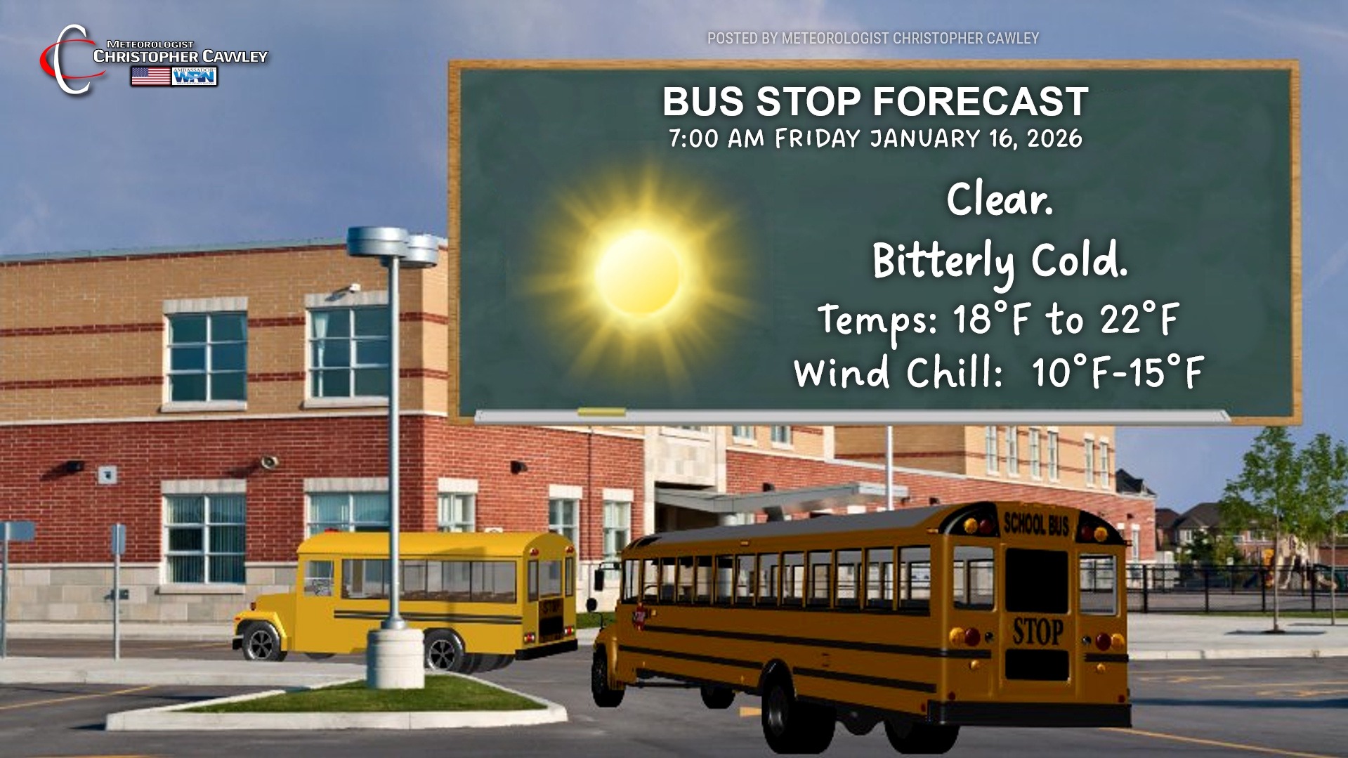
Despite full sunshine on Friday, our highs will only be in the upper 40s.
A southerly flow takes place Friday night into Saturday. Lows early Saturday will be in the lower 30s (right on target for this time of year), with dramatically warmer temps on Saturday rising into the lower 60s ahead of the next Arctic cold front.
Which brings me to big point number two:
WILL IT SNOW ON SUNDAY?
The short answer: It’s too soon to know for sure.
The long answer: A very complicated weather pattern is taking shape for the weekend, which COULD — heavy emphasis on the word COULD — lead to frozen precipitation.
As I stated numerous times last winter, there are two ways we can get measurable snow here in Columbus County.
1. Cold air already in place accompanied by a storm system offshore.
2. A frontal system approaches the coast, with a wave of low pressure forming. Cold air rushing in behind the front changes rain to snow.
The scenario we’re looking at for Sunday is #2. An Arctic front will push off the coast Saturday night. Temperatures nosedive into the 20s during the overnight. Meanwhile, a “shortwave” (which is a disturbance in the middle and upper levels of the atmosphere) will be pushing southeastward and reach the southern Appalachians early on Sunday. A southwest wind flow developing ahead of this shortwave may push some moisture “over the top” of the Arctic airmass at the surface. If this happens, light wintry precipitation COULD be the result. No guarantees.
Here’s where this gets tricky. Colder air will be rushing in behind the Arctic front. A surface low MIGHT form on this front somewhere along the SC or NC coast. This would enhance whatever precip is coming from the shortwave mentioned above. It will also “pull down” even more Arctic air into the whole equation.
The best chances for snow (all snow) at this point (and it’s so early right now — keep that in mind) are inland areas… I’m not going to try to pinpoint it but the farther inland the better the chance. Closer to the coast, closer to whatever surface low might form, a rain/snow mix is more likely… or even a cold rain.
And then there’s the chance the shortwave doesn’t move as modeled and/or no low forms on the coast. In that case, Sunday will be mostly sunny and cold with no precip at all.
So the variables: a) how much cold air will be in place, b) what kind of moisture is available, and c) will a low form off the coast.
It’s too early to make any prediction on accumulation, despite what you’re seeing on social media (including the “splashy graphics meteorologist”). It’s VERY DIFFICULT to get significant measurable snow here (2 inches or greater), especially in this kind of scenario.
The event we had last January was a case of cold air already in place and a southern-stream low — an entirely different scenario.
Try to ignore the craziness on social media. Sadly, many of the deterministic model charts are freely available, and people enjoy sharing them with very little context.
I’m not going to post all the various model plots here because they’re going to change about a dozen times between the time you read this and 24 hours afterwards.
The bottom line? This could end up being nothing — sunshine and a high in the 40s — or it COULD be — COULD be a couple inches of snowfall and highs in the upper 30s.
“Stay tuned!”
Here’s your Freedom Insurance Today-plus-Five Forecast!
–Meteorologist Christopher Cawley