CCN Weather Update for Wednesday January 28, 2026.
This weather update is sponsored by Freedom Insurance of Whiteville. You can trust Freedom Insurance to give you clear blue skies when it comes to home, car, boat, or whatever insurance you need. Let Freedom provide customized coverage to keep you and your family safe. Contact Freedom today at 910-640-2828!
Here’s today’s Bottom Line:
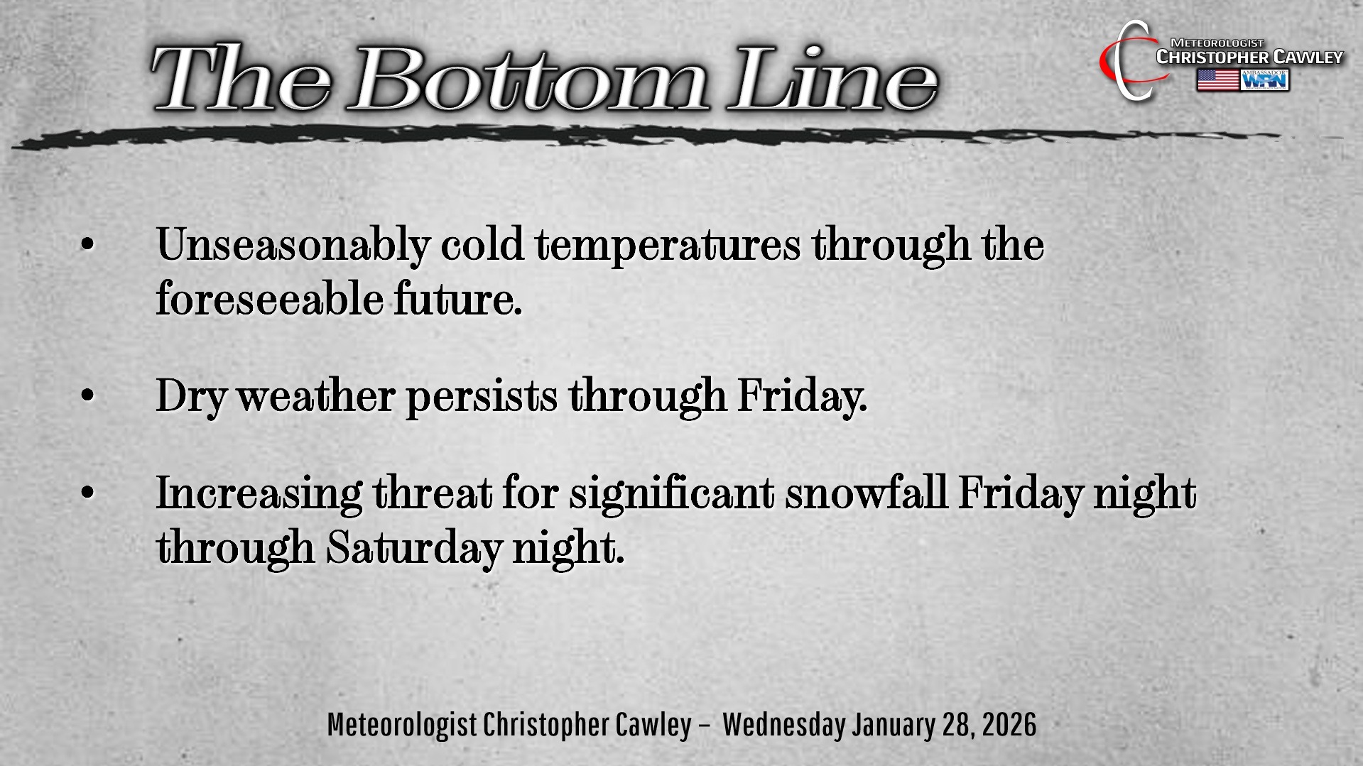
Cold and dry weather will continue through the end of the week, with temperatures running 10+ degrees below seasonal normal values. Weather conditions will continue to be remarkably unremarkable … until late Friday.
SATURDAY SNOWSTORM? MAYBE.
Unless you’ve been living under a bunch of boulders, you’ve heard that there is another potential storm coming for the weekend.
This one will be “snow… or no.” Deep cold air over the land surface, combined with Gulf moisture from an offshore low, combined with an upper-level low diving southward out of Canada… COULD combine to produce accumulating snowfall to the area for Saturday.
COULD combine.
Timing is everything. And it’s the timing that the modeling is having trouble resolving at this time.
Location is also everything. And it’s the location of the low that the modeling is having trouble resolving at this time.
Ensemble trends vary wildly for Whiteville, with accumulations ranging from as little as an inch … to upwards of 20 inches.
As for precipitation type, like I said, it’s either “snow or no.” There is zero threat that warmer air builds higher in the atmosphere, like last weekend. If the offshore low comes too close to the coast, we’ll get a bone-chilling rain with temps in the mid 30s (a highly unlikely solution). If the storm system is too far offshore, we’re left with highs in the mid 20s under a bone-dry air mass.
Every model and ensemble plot says there will be an offshore low. So that we can take to the bank. The ensembles suggest that it will be close enough to the coast to produce some snow accumulations here.
The upper low diving south out of Canada is very important. European guidance yesterday evening showed this phasing (combining) with the coastal low… and absolutely obliterating the area with snow (feet of snow). I don’t buy these numbers… while it COULD happen, I just don’t believe it.
The trends on the National Blend of Models suggest a 2- to 5-inch snowfall here. That’s not a forecast, but that’s what the NBM is illustrating, and that’s actually quite reasonable.
I’ll be able to make a “first call” snow accumulation map later this evening, and I’ll post that on my socials.
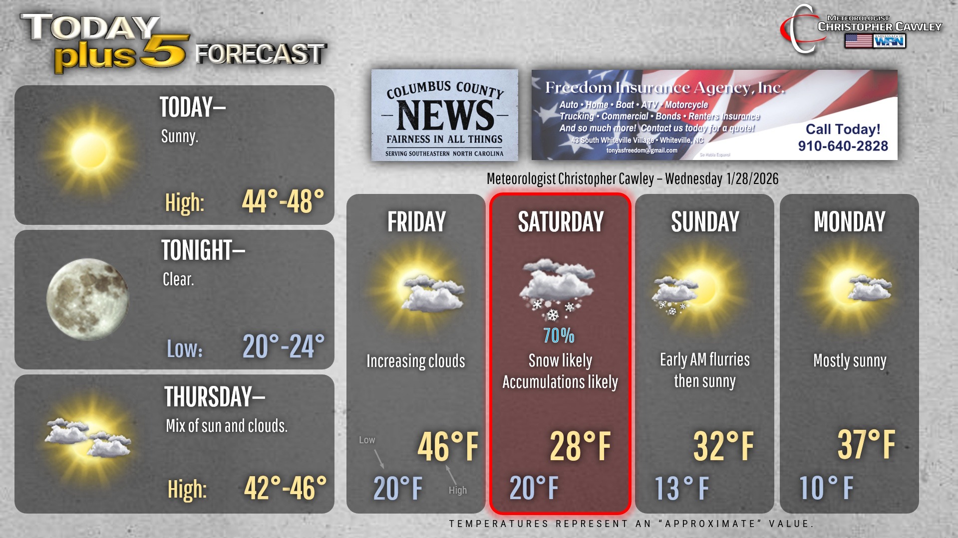
As for timing, assuming everything comes together as scheduled… expect snow to develop after midnight Friday night, lasting through the day Saturday, tapering off Saturday night.
BITTERLY COLD TEMPERATURES are virtually a lock during and after the storm. Highs Saturday likely won’t get above 30… while lows early Sunday morning fall to between 10 and 15 degrees. These lows may even be colder if we have a snow-covered ground (which acts as a refrigerator at the ground surface).
IN SUMMARY —
1. Plenty of cold air in place. Precipitation will be snow… or nothing at all.
2. Upper low diving out of Canada needs to phase with the southern jet low.
3. Some snow is likely from the southern-stream low, with at least modest accumulations.
4. Timing of the phasing of the upper and coastal lows is important… as is the location of the coastal low. A “Goldilocks solution” where everything comes together just right will result in a very heavy snow accumulation.
5. Bitterly cold temps into next week.
Whatever snow we get will be very dry and fluffy. Normally we have an 8:1 ratio (snow to liquid); this storm will likely be 10-12:1. Therefore power outages from the weight of snow on power lines is not likely to be an issue. There will also be “blowing and drifting” of snow thanks to gusty winds and the roads Saturday night through Sunday will likely be an icy/snowy mess.
And there is still a chance we get nothing whatsoever. So ….
“Stay tuned.”
Here’s your Freedom Insurance Today-plus-Five Forecast!
–Meteorologist Christopher Cawley