Greetings folks, Meteorologist Christopher Cawley here with your CCN Daily Weather Update for Friday January 10, 2025.
WINTER WEATHER ADVISORY is posted for this evening into early Saturday morning for freezing rain.
Quiet conditions for the most part today, though skies will become cloudy. Now that we’re close enough to the event, I have the benefit of looking at short-term high-resolution modeling. The NAM3k is more aggressive in terms of frozen precip than the HRRR (which shows essentially no frozen precip). I think I’m going to lean closer to the NAM guidance for this event.
But really… it’s not going to be all that bad, folks.
Here’s how it pans out. A relatively weak area of low pressure will move across the southeast today and then offshore by Saturday afternoon. Generally light precipitation will move south to north across the county.
Again, I’m going to lean into the NAM guidance solution. Precipitation develops in the mid-afternoon at the cloud layer, but that’s going to be falling into a layer of very dry air closer to the surface. This falling precip will evaporate … and cool the atmosphere. By roughly 5 PM, some light snow or sleet may start to reach the ground, maybe mixed with some raindrops. The temperature at the surface will quickly dip below freezing after sunset … likely bottoming out around 30°F.
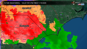
Let me digress and briefly explain the difference between freezing rain and sleet. It all starts out as snow at the cloud layer. As the snow falls from the cloud, it encounters a layer of the atmosphere that is above freezing. If this layer is shallow (narrow), the snowflake melts into a raindrop, and then re-freezes into an ice pellet. This is sleet.
If the warmer layer is thick, the snowflake melts into a raindrop. The cold layer at the surface is thin, no more than about 500-1000 feet. The raindrop does not have “time” to re-freeze, and instead becomes “supercooled.” It freezes instantly into a glaze upon contact with the ground or any other object. This is freezing rain. It SEEMS like it’s raining, but if the ground temp is below 32°F, it’s freezing rain.
Ok, with that out of the way, as we move through the evening hours, a several-hour period of generally light freezing rain is expected.
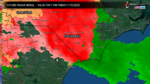
After about 8 PM, the freezing rain becomes more “showery” in nature, and by 10 PM, the NAM guidance suggests we start popping above freezing at all levels, ground to cloud.
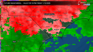
From that point, by midnight, we’re all rain everywhere, according to the model. The model does not take into account the potential that there may still be some isolated spots that remain at about the freezing mark just a bit longer. But on the whole, we should be all liquid by 1 AM Saturday.
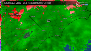
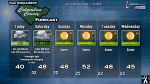
Periods of light rain continue through sunrise, and then will taper off from southwest to northeast by mid-morning. Our skies will become sunny by the afternoon, and the whole thing is a memory.
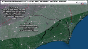
AMOUNTS: NWS says that ice accumulations across the county could be as much as a tenth of an inch (the thickness of two pennies stacked together). I think it’s going to be closer to 0.05″ (half the NWS amount), but at that point the difference is negligible. In any case, you could expect a glaze to develop on metal surfaces and vehicles, perhaps some slipperiness to sidewalks. Icy spots form on bridges and overpasses, but honestly I don’t think the main roads will have too many problems as they have been treated with anti-icing material. Secondary roads may be a little dangerous late this evening, but as the precip transitions to rain and temperatures rise into the mid 30s, this icing should melt off. I believe that by Saturday morning, there won’t be any noticeable ice remaining. I’m not really changing my ice accumulation map that I posted at 4:30 PM yesterday… maybe just tweaking it a little bit. The extreme southern parts of the county probably won’t receive much of any ice accumulation.
LONGER RANGE: High pressure builds in Sunday, slips off the coast on Monday. A weak “Alberta Clipper” system brings light snow to the northeast US and drags a dry cold front over the area late Monday/early Tuesday… with a resumption of our below-normal temperatures. I think the cold is going to loosen it’s grasp on our area after about the 19th/20th. No significant storm systems on the horizon.
Thanks for reading. Please take it easy if you have travel plans this evening. I will post updates on my FB page as needed, and if conditions warrant, I will post a special weather update here on CCN. As always, take care.
–Meteorologist Christopher Cawley

