Greetings everyone, welcome to your Monday edition of the CCN Daily Weather Update.
Well there’s not much to talk about this week. We’ll have another blast of really cold air hitting during the midweek time-frame, and then potentially a dramatic (but really brief) warm-up going into the weekend. Our next precipitation chances come this weekend.
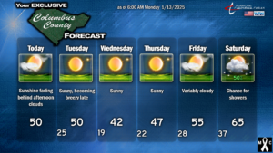
In the short term, for today and tomorrow we’ll have two fronts that push through. The first one will push through this afternoon, with some cloudiness, but it will be an otherwise benign frontal passage. It’ll be cold again tonight, lows dropping deep into the 20s. The next front is slated to hit Tuesday afternoon. We’ll have a push of “warmer” (relatively speaking) air ahead of the front, and our highs may touch 50 once again.
Somewhat blustery and impressively cold temps once again arrive late Tuesday night into Wednesday morning. Wind chill values may reach as low as 10-15, and if this ends up being the case, the NWS may issue a Cold Weather Advisory. Temperatures at the bus-stop Wednesday morning will likely be between 18°F and 22°F… so be ready for that. Wednesday’s highs… I’m being optimistic putting a “42” on the graphic. Portions of the county might not crack the 40-degree mark.
After another brisk day on Thursday, we warm up to seasonal normal values for Friday… and then shoot some 10 degrees ABOVE normal by Saturday on the arrival of our next weather system.
Don’t get used to that warmth. It’s almost cruel, how short-lived it’s going to be.
There are a million question-marks with the system set to impact the area this weekend. The operational European and operational GFS aren’t quite on the same page with regard to timing. They both say, yes, there’s a front that will clear the coast… with the potential for an area of low pressure to develop on the front. The Euro says the low passes either just to our west or almost directly overhead, with breezy and rainy conditions Friday night through Saturday night, while the GFS says naah, let’s wait until Sunday with this, and the low is pretty much a nothingburger. Both models, and the ensembles, point to highs in the 60s, possibly reaching 70, over the weekend. I think the most likely scenario is what is illustrated by the model blend set, essentially combining all of the different scenarios. I’m going with a 50/50 shot of rain on Saturday with highs jumping all the way into the mid 60s.
Then things could get somewhat interesting. The front pushes offshore and another deep Arctic blast dives southward out of Canada. High pressure ridging over the central and northern Atlantic ocean, combined with the Arctic high building down the Ohio valley, sandwiches an upper level trough across the east. This sets the stage for the POTENTIAL that some kind of low pressure spins up in the northern the Gulf…. almost exactly like what we had this past Friday/Friday night, and then “rounds the corner” and comes up the coast. It’s way too far out in time to pinpoint details, so I’m not even going to try at this point. But something to think about when making longer-range plans (roughly the 21st-23rd of January). Again, I’m not making any predictions at this point, but **IF** this system develops, there is a definite threat for wintry precipitation across ColCo. Stay tuned.
With the exception of this weekend, when we might make a run at 70, the colder-than-normal weather (on the whole) is likely to last through the end of the month.
Here’s your 6-day forecast graphic.
Thank you, as always, for reading and sharing this blog post, and for supporting Columbus County News!
–Meteorologist Christopher Cawley


