Greetings everyone, welcome to the Saturday morning edition of the CCN Weather Update!
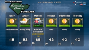
COLD. That’s the word for today. Surface high pressure over Saskatchewan (Canada) will ridge all the way southeastward into our area. Even with full sunshine today, our highs will struggle to the lower and middle 40s. Fortunately the winds shouldn’t be too big of a factor. Nearly cloudless sky expected today.
High pressure builds overhead tonight and then gradually off the coast. Temperatures drop like a rock after sunset this evening, and with clear skies and calm winds, we’re dropping to the lower 20s across the county by early Sunday morning.
The high shifts offshore for Sunday allowing a return flow of more southerly air ahead of our next weather system. This allows our temps to rise to the lower and possibly middle 50s with mostly sunny skies. Cloudiness will start to build in during the later part of the afternoon.
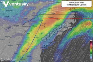
A warm front will lift from south to north Sunday night as a surface low pressure center moves across Tennessee. Cold air might remain a bit stubborn early Sunday night, but temperatures will gradually rise through the night. Bus-stop temps Monday morning should be in the lower 40s. Shower chances ramp up during the night as that warm front moves through.
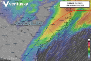
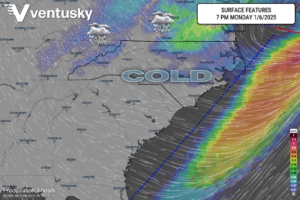
The most active weather for this week takes place on Monday, and while I don’t expect any severe weather, I’m calling a “weather action day” anyway. The warm front pushes to the north early, followed by a cold front during the afternoon hours (see Ventusky charts below). The low-pressure center will move along the NC/VA border and then off the DelMarVa coast by Monday night. Showers (fairly widespread) are likely just ahead of the cold front passage on Monday, and we could see a burst of moderate to briefly heavy rainfall. Shear values look quite strong but there’s no instability to speak of, so there won’t be any thunder with this. Winds about 1,000 feet off the ground will be absolutely howling, and it is easy to anticipate that wind gusts at the surface could reach 45-55 mph especially from about 10 AM to 3 PM on Monday. That is why I’m declaring a “weather action day.” Our highs will be very warm ahead of the cold front — middle 60s across the county — but the temps are going to spiral downward as cold air rushes in Monday night.
Monday night through Thursday will be dry and cold as strong Arctic high pressure builds in. Even though I put a “40” on the chart for Thursday, that might be a stretch. Temperatures in the upper teens to lower 20s will greet school children at the bus stop Wednesday, Thursday, and Friday mornings. Please make sure they’re dressed appropriately for that.
Looking farther ahead to the weekend I’ve been talking about for several days now. It’s still too soon to call anything specific, but in looking at our modeling, there are huge differences in solutions amongst ECMWF (Euro), GFS, and the Canadian models.
The latest GFS (as of this writing) shows a storm system gathering in the northern Gulf on Friday, lifting across Florida and then up the Carolina coast on Saturday into Sunday. It hugs the coast, which is too close if you want a snowfall here. The model depicts a period of possibly significant freezing rain transitioning to rain developing early Saturday morning, with a cold rain likely Saturday, tapering off late. Cold air “chases” the departing storm, and this may lead to a changeover to some wet snowflakes, but the model pulls most of the moisture out of here before that takes place.
The European develops a southern stream low but keeps the low center overland, lifting northeast across SC and NC during the day on Saturday. This brings an all rain scenario south of a line from Concord through Raleigh to Elizabeth City. The storm departs and dry air pushes in before the cold air returns. No snow by that solution.
Canadian modeling has high pressure holding tough into Sunday before allowing a storm system to lift northeast along the coast into Monday, showing an all-rain scenario.
Looking at the ensembles, 3 out of the 30 GFS ensemble members depict snow here, while 20 out of 50 of the European ensembles say it will snow in Columbus County.
I want to see snow as much as the next person, but I’m not liking our odds.
I also don’t think the Arctic blast(s) we’re getting ready to receive are going to be as bad as previously illustrated back at the beginning of the month. Thursday and Friday this week will be bitterly cold, and I think we’ll see similar temperatures through at least mid-month… but I don’t think it’s going to be anything generational or historic.
Ok readers, that’ll do it for today’s report. As always, I thank you for your time and supporting Columbus County News. As always, take care.
–Meteorologist Christopher Cawley

