Greetings folks, welcome to today’s edition of the CCN Weather Update, once again brought to you by Freedom Insurance. Call 910-640-2828 today and Freedom’s experts will be more than happy to help you set up policies for auto, home, boat… whatever you need insured, Freedom Insurance has your back. Call them today!
Ok. It’s show time.
A WINTER STORM WARNING has been posted. This goes into effect at 9 PM this evening and runs until 8 AM Wednesday morning.
Trends are honing in on decent accumulating snows here in Columbus County! Look for snow to start developing around suppertime, along the state line first and then quickly overspreading the rest of the county. The peak of our storm will occur mainly through about 1-2 AM, after which time the snow should come to an end. It’ll be a quick hit, in and out of here.
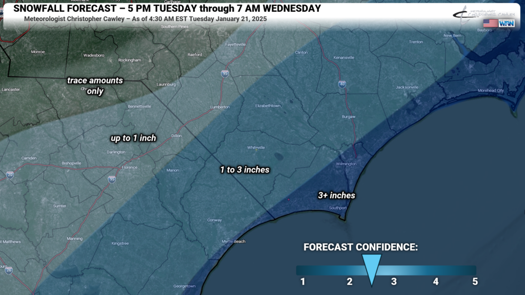
Storm total accumulations of 1-3 inches are expected across the county. There may be some spots with a little bit more, some spots with less. But I think, on average, we’re all going to wake up to a blanket of white on Wednesday morning.
I mean, if it’s going to be this doggone cold, we might as well have some snow and a day off on Wednesday to enjoy it.
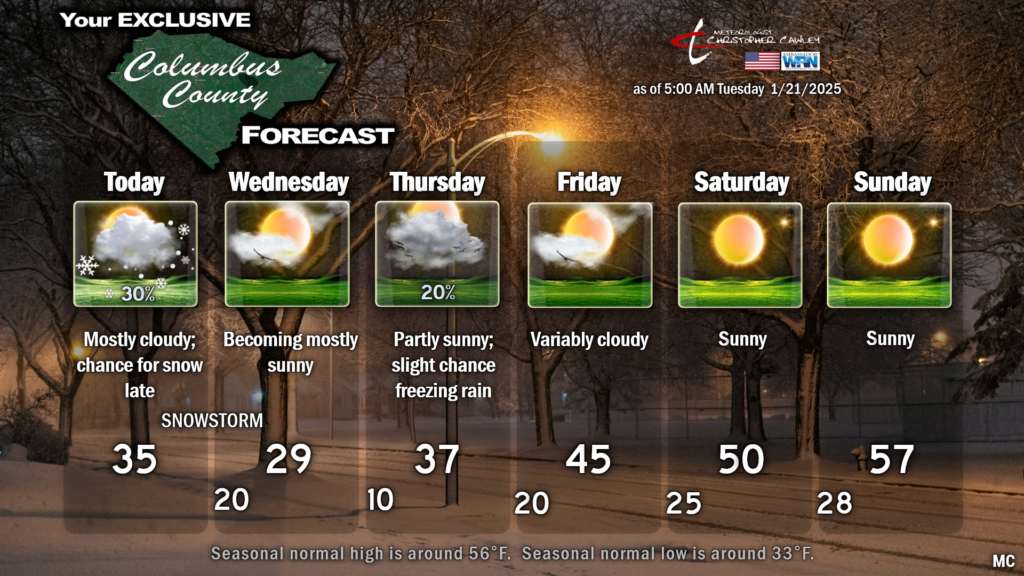
The snow will not melt much during the day Wednesday as our temperatures will struggle to reach the 30-degree mark. Any melting that does occur becomes hard black ice Wednesday night; depending on how much snow falls, secondary roads could be an absolute nightmare heading into Thursday morning.
It is going to be BRUTALLY COLD here Wednesday night. With fresh snow cover, I’m gonna “go low, go low, go low.” How low? About 10 degrees. Without the wind chill. And that might be generous. I expect some of the outlying areas of the county drop into the upper single digits. Pocosin soil areas may drop to the lower single digits. I’m not kidding. (Holly Shelter area, I know it’s not in ColCo, but it wouldn’t surprise me if they dipped to about zero Wednesday night.)
IF there’s school on Thursday, expect 7 AM temps at the bus-stop to run between 8-13 degrees. Without the wind chill.
My official snow forecast is attached here. There is some “bust” potential, both high and low, hence my “2.5” on the confidence scale. As the low scurries up the coast, if the atmospheric forcing is timed perfectly with the greatest moisture availability (the highest “PWAT” or “precipitable water” value)….. and if that just happens to occur over land…. there’s an outside chance of 5-6 inches of snow across the county. Those are a lot of “ifs.” The timing is key, and the window for that is only about 1-2 hours. This is a fast-moving low.
There is also the potential that the storm center itself comes too close to the coast. That would inject sleet into the picture. So instead of the areas in dark blue getting 3-4 inches of snow, they could get 1-2 inches of snow/sleet crusty/icy mixture. One of the short-term modeling pictures did show a robust “band” of sleet extending deep into ColCo, to about the Seven Creeks Highway. I thought about that when drawing out the map below, but then decided to just stick with what I had.
As for the second wintry precipitation threat Thursday and Friday, a decaying frontal boundary will exist offshore, and a bit of low pressure may try to get it’s act together along this front. Yesterday evening’s deterministic GFS and Euro both are mainly dry for Thursday into Friday, keeping all of the precipitation offshore. I’m not sold on that quite yet, so I’m going to leave a 20% chance for some light freezing rain Thursday afternoon in my forecast.
A dramatic warm-up takes shape as we move into the weekend, with temperatures rising to ABOVE NORMAL levels by Sunday and Monday (not shown on the graphic). I was looking at longer-range modeling and let’s just put it this way: Hang in there, warmer days are coming, especially when we switch the calendar to February. I cautiously state that what we’re experiencing now may be the coldest for the winter.
That’ll wrap this up. Thank you for reading and supporting CCN. Thank you for supporting my sponsor, Freedom Insurance of Whiteville. Enjoy the snow… but if you must travel this evening, please allow A LOT of extra time to reach your destination. Better yet, if you don’t have to go out tonight, don’t. Take care, folks.


