Hello everyone, happy FRIDAY! Welcome to the CCN Daily Weather Update!
We’re proudly sponsored by our friends at Freedom Insurance of Whiteville. No matter what your insurance needs are, Freedom Insurance can write the best policy for you and for your checkbook. Call them today at 910-640-2828 or stop in their office across from Lowe’s, by the southside Hills shopping plaza.
STATISTICS FOR WHITEVILLE – Thursday February 6, 2025.
High: 73.7°F at 4:15 PM (normal is 56)
Low: 44.3°F at 7:07 AM (normal is 32)
Precip: 0.00 in
View live, real-time weather data for Whiteville on my College Street Weather Station.
Here’s your Bottom Line for today…
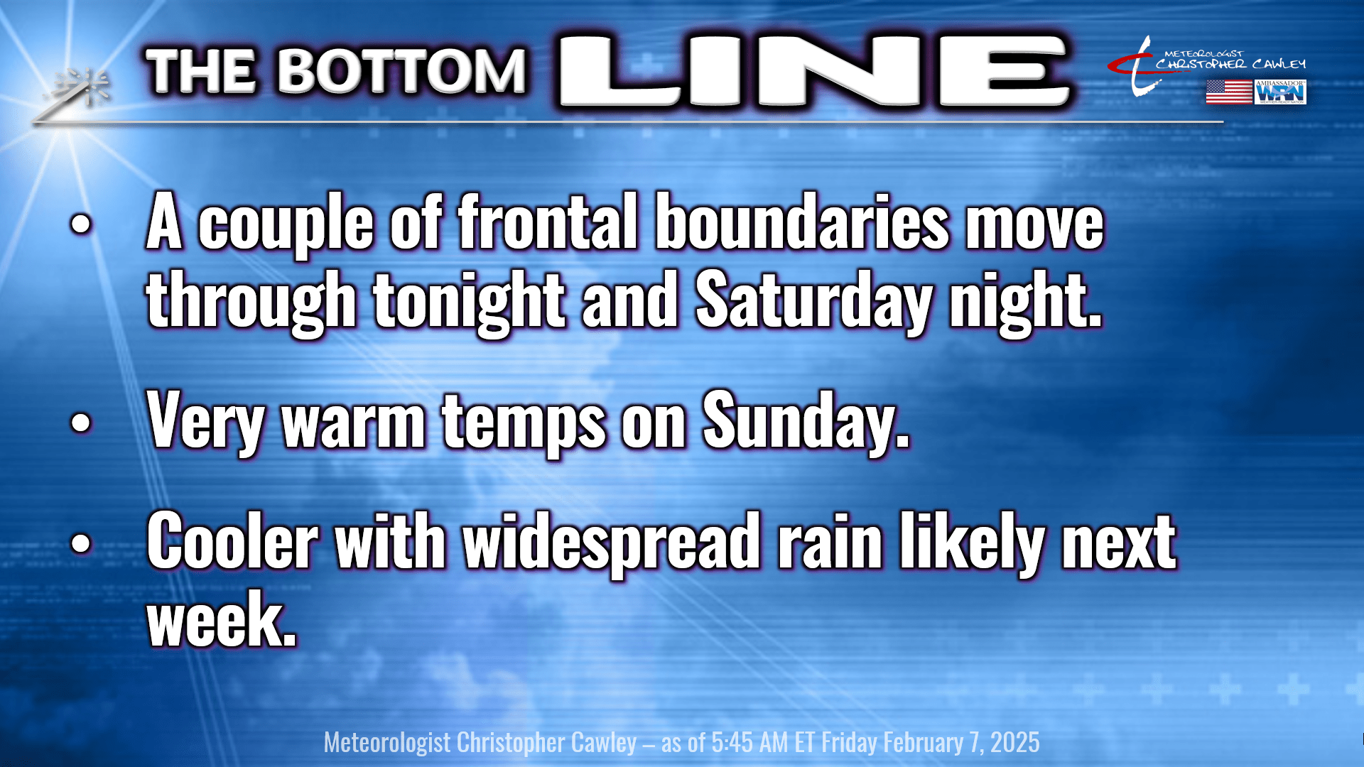
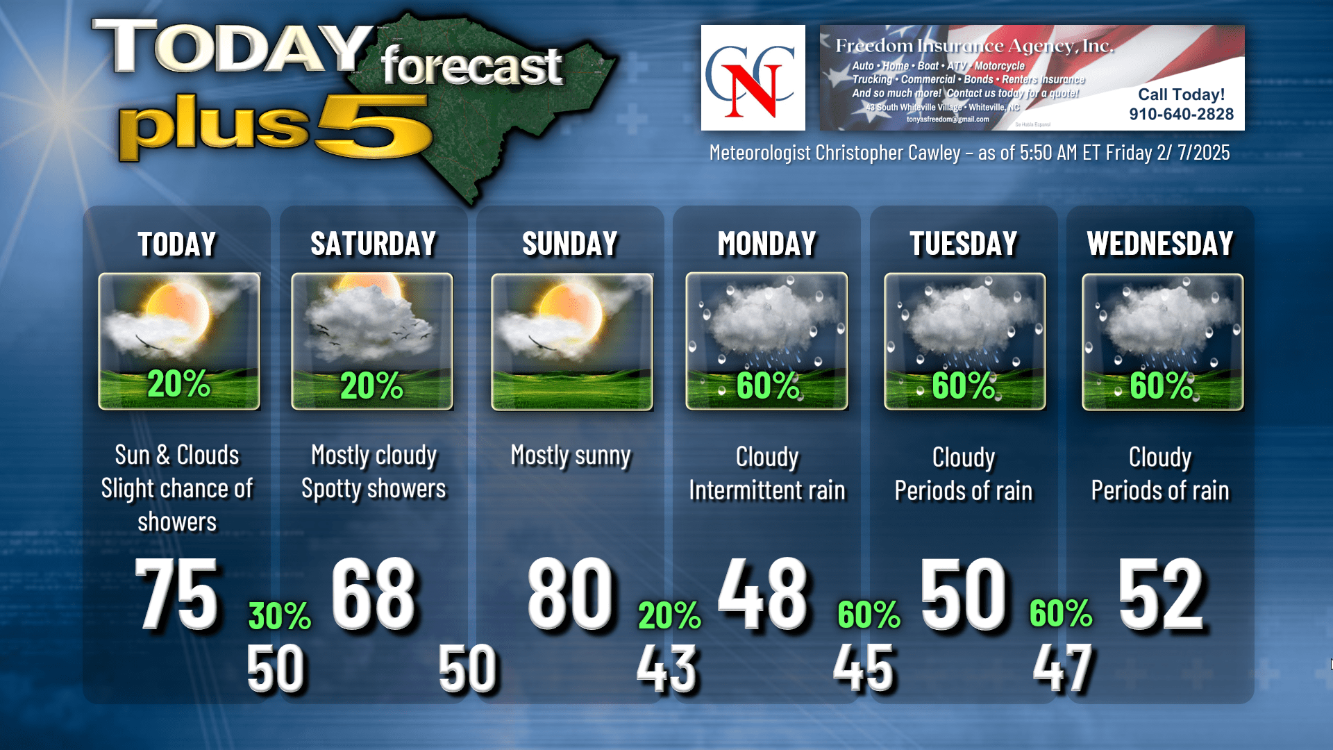
Warm temperatures across the county today. A cold front will approach from the north this afternoon and this might trigger a scattered shower or two late in the afternoon, but the chances are relatively low on that. It’ll be somewhat humid today and you can expect highs in the mid 70s.
The cold front SHOULD pass just to our south tonight … but may hang up directly over the county. Saturday’s high temperature will be highly dependent on where the front ends up. If the front is able to push southward into SC, our highs will only be in the upper 40s to mid 50s. If the front hangs up just to our north, say from Lumberton to E-town to Clinton, highs jump into the mid 70s. I’m hedging my bets that the front will drop to approximately the state line, extending from Charlotte to Wilmington, then snaking north along the coast. Should this be the case, expect highs in the mid to upper 60s, and that’s what I put on the graphic below. Just keep in mind, the range on the ensemble modeling is from around 50 to around 80. Not much confidence in this forecast.
A little wave of low pressure forms on the front Saturday afternoon, lifts quickly northeastward along the coast, and drags the front northward Saturday night. This may trigger a few showers. Early lows Saturday night in the upper 50s, but temps will actually rise during the night.
We’re deep in the warm sector on Sunday with a downsloping wind flow, lots of sunshine, and highs around 80. The guidance has a range between 75 and 90… yes 90. We’re not going to get that warm though. I put 80 on the graphic.
STRONG cold front moves into the area Sunday evening, slowing down as it approaches, and eventually stalls to our south on Monday. Guidance suggests that moisture is limited with the frontal passage. I put a 20% chance on the graphic but I don’t think we’ll see much, if anything, with the actual frontal passage.
We enter a period of cloudy and rainy conditions through much of next week. It’s likely to be quite cold on Monday with highs in the upper 40s to lower 50s with periods of rain throughout the day.
For Tuesday and Wednesday…
High confidence: Clouds and rain likely, possibly a soaking rainfall.
Low confidence: Temperature forecast.
The frontal boundary is likely to remain stalled along or just inland from the coast. Waves of low pressure move north along the front bringing periods of rain through the period. Model blends still indicate a good soaking rainfall possible Tuesday through … actually Thursday into Friday.
Temperatures… ugh. The front will be the determining factor on where our temps end up. If the front actually retrogrades to our west, say, toward I-95, then our highs may be in the 60s and 70s with more “convective” type precipitation — showers and thunderstorms. If the front stays hung up on the coast, we’re on the cold side, and our highs are in the upper 40s to lower 50s, with not much temp drop at night.
Ensemble spreads are huge. Euro ensemble spread for Tuesday indicates highs between 42 and 77. Wednesday is 45 to 80. I think I’m going to lean on the cooler side of guidance, but just keep in mind that could change quite a bit as we get closer in time.
As far as frozen precip chances go, only 3 out of 82 total ensemble members indicate snow next week. It ain’t gonna happen, my friends. If you want snow, book a trip to the Tug Hill of upstate New York, where they have received over 200 inches this season (!!) and new accumulations through the weekend will be significant. They can have it!
Here’s your Freedom Insurance Today-Plus-5 forecast for Columbus County.
I hope you’re able to get outside and enjoy the warmth today. Have a wonderful day, and, as always, take care!
~Meteorologist Christopher Cawley